DAYS OF FUKUSHIMA PAST?
The tragedy of the earthquake/tsunami in Japan 15 months ago, followed quickly by the meltdown of no less than three nuclear reactors in the Fukushima Dai-ichi complex has fallen completely off the radar of the global corporate media. However, there are still significant hazards occurring there, which could affect everyone in the Northern Hemisphere, not just those in Japan, or along the west coast of North America, including Alaska.
This is because there is one particular building in the Fukushima reactor 4 complex that is of great concern. It is a building containing spent nuclear fuel rods that are still "hot" and must be kept from overheating, or they will catch fire and create a monstrous plume of lethal radioactivity, which scientists now say, if it were to occur, and spread to the other pools in the Fukushima reactor complex, could be 85 times worse than the radionuclide/radiation releases that occurred from Chernobyl, in the Ukraine in 1986. But you are not hearing about it in the corporate media. And the earthquake hazard there is just as great now as before the monstrous magnitude 9.0 quake last year, which would lead to this worst-case scenario.
http://www.alternet.org/story/155283/the_worst_yet_to_come_why_nuclear_experts_are_calling_fukushima_a_ticking_time-bomb?page=entire
The Worst Yet to Come? Why Nuclear Experts Are Calling Fukushima a Ticking Time-Bomb
Experts say acknowledging the threat would call into question the safety of dozens of identically designed nuclear power plants in the U.S.
May 4, 2012 |

Photo Credit: Shutterstock/ Sergey150770
More than a year after the triple meltdown at the Fukushima Daiichi power plant, the Japanese government, Tokyo Electric Power Company (Tepco) and the U.S. Nuclear Regulatory Commission (NRC) present similar assurances of the site's current state: challenges remain but everything is under control. The worst is over.
But nuclear waste experts say the Japanese are literally playing with fire in the way nuclear spent fuel continues to be stored onsite, especially in reactor 4, which contains the most irradiated fuel -- 10 times the deadly cesium-137 released during the 1986 Chernobyl nuclear accident. These experts also charge that the NRC is letting this threat fester because acknowledging it would call into question safety at dozens of identically designed nuclear power plants around the U.S., which contain exceedingly higher volumes of spent fuel in similar elevated pools outside of reinforced containment.
Reactor 4: The Most Imminent Threat
The spent fuel in the hobbled unit 4 at Fukushima Daiichi not only sits in an elevated pool outside the reactor core's reinforced containment, in a high-consequence earthquake zone adjacent to the ocean -- just as nearly all the spent fuel at the nuclear site is stored -- but it's also open to the elements because a hydrogen explosion blew off the roof during the early days of the accident and sent the building into a list.
Alarmed by the precarious nature of spent fuel storage during his recent tour of the Fukushima Daiichi site, Sen. Ron Wyden, D-Oregon, subsequently fired off letters to Secretary of State Hillary Clinton, Secretary of Energy Steven Chu, NRC Chairman Gregory Jaczko and Japanese ambassador to the U.S. Ichiro Fujisaki. He implored all parties to work together and with the international community to address this situation as swiftly as possible.
A press release issued after his visit said that Wyden, a senior member of the U.S. Senate Committee on Energy and Natural Resources who is highly experienced with nuclear waste storage issues, believes the situation is "worse than reported," with "spent fuel rods currently being stored in unsound structures immediately adjacent to the ocean." The press release also noted the structures' high susceptibility to earthquakes and that "the only protection from a future tsunami, Wyden observed, is a small, makeshift sea wall erected out of bags of rock."
As opposed to units 1-3 at Fukushima Daiichi, where the meltdowns occurred, unit 4's reactor core, like units 5 and 6, was not in operation when the earthquake struck last year. But unlike units 5 and 6, it had recently uploaded highly radioactive spent fuel into its storage pool before the disaster struck.
Robert Alvarez, a nuclear waste expert and former senior adviser to the Secretary of Energy during the Clinton administration, has crunched the numbers pertaining to the spent fuel pool threat based on information he obtained from sources such as Tepco, the U.S. Department of Energy, Japanese academic presentations and the Institute of Nuclear Power Operations (INPO), the U.S. organization created by the nuclear power industry in the wake of the 1979 Three Mile Island accident.
What he found, which has been corroborated by other experts interviewed by AlterNet, is an astounding amount of vulnerably stored spent fuel, also known as irradiated fuel, at the Fukushima Daiichi site. His immediate focus is on the fuel stored in the damaged unit 4's pool, which contains the single largest inventory of highly radioactive spent fuel of any of the pools in the damaged reactors.
Alvarez warns that if there is another large earthquake or event that causes this pool to drain of water, which keeps the fuel rods from overheating and igniting, it could cause a catastrophic fire releasing 10 times more cesium-137 than was released at Chernobyl.
That scenario alone would cause an unprecedented spread of radioactivity, far greater than what occurred last year, depositing enormous amounts of radioactive materials over thousands of miles and causing the evacuation of Tokyo.
Nuclear experts noted that other lethal radioactive isotopes would also be released in such a fire, but that the focus is on cesium-137 because it easily volatilizes and spreads pervasively, as it did during the Chernobyl accident and again after the disaster at Fukushima Daiichi last year.
With a half-life of 30 years, it gives off penetrating radiation as it decays and can remain dangerous for hundreds of years. Once in the environment, it mimics potassium as it accumulates in the food chain; when it enters the human body, about 75 percent lodges in muscle tissue, including the heart.
The Threat Not Just to Japan But to the U.S. and the World
An even more catastrophic worst-case scenario follows that a fire in the pool at unit 4 could then spread, igniting the irradiated fuel throughout the nuclear site and releasing an amount of cesium-137 equaling a doomsday-like load, roughly 85 times more than the release at Chernobyl.
It's a scenario that would literally threaten Japan's annihilation and civilization at large, with widespread worldwide environmental radioactive contamination.
"Japan would suffer the worst, but it would be a global catastrophe," said Kevin Kamps, nuclear waste expert at the watchdog group Beyond Nuclear. "It already is, it already has been, but it would dwarf what's already happened."
Kamps noted that these pool fires were the beginning of the worst-case analysis envisioned by the Japanese government in the early days of the disaster, as reported by the New York Times in February.
"Not only three reactor meltdowns but seven pool fires at Fukushima Daiichi," Kamps said. "If the site had to be abandoned by all workers, then everything would come loose. The end result of that was the evacuation of Tokyo."
In an interview with AlterNet, Alvarez, who is a senior scholar at the Institute for Policy Studies, said that the Japanese government, Tepco and the U.S. NRC are reluctant to say anything publicly about the spent fuel threat because "there is a tendency to want to provide reassurance that everything is fine."
He was quick to note, "The cores are still a problem, make no mistake, and there will be some very bad things happening if they don't maintain their temperatures at some sort of stable level and make sure this stuff doesn't eat down through the concrete mats."
But he said that privately "they're probably more scared shitless about the pools than they are about the cores. They know they're really risky and dangerous."
AlterNet asked the NRC if it is concerned about the vulnerability of the spent fuel at Fukushima Daiichi and what, if anything, it had expressed to the Japanese government and Tepco on the matter.
"All the available information continues to show the situation at Fukushima Dai-ichi is stable, both for the reactors and the spent fuel pools," NRC spokesman Scott Burnell replied via email. "The available information indicates that Spent Fuel Pool #4 has been reinforced."
But nuclear experts, including Arnie Gundersen, a former nuclear industry senior vice president who coordinated projects at 70 U.S. nuclear power plants, and warned days after the disaster at Fukushima last year of a "Chernobyl on steroids" if the spent fuel pools were to ignite, strongly disagreed with this assessment.
"It is true that in May and June the floor of the U4 SFP [spent fuel pool] was 'reinforced,' but not as strong as it was originally," Gundersen noted in an email to AlterNet. "The entire building however has not been reinforced and is damaged by the explosion in both 4 and 3. So structurally U4 is not as strong as its original design required."
Gundersen, who is chief engineer at the consulting firm Fairewinds Associates, added that the spent fuel pool at unit 4 "remains the single biggest concern since about the second week of the accident. It can still create 'Chernobyl on steroids.'"
Alvarez said that even if the unit 4 structure has been tentatively stabilized, it doesn't change the fact "it sits in a structurally damaged building, is about 100 feet above the ground and is exposed to the atmosphere, in a high-consequence earthquake zone."
He also said that the urgency of the situation is underscored by the ongoing seismic activity around northeast Japan, in which 13 earthquakes of magnitude 4.0 to 5.7 have occurred off the northeast coast of Honshu between April 14 and April 17.
"This has been the norm since 3/11/11 and larger quakes are expected closer to the power plant," Alvarez added.
A recent study published in the journal Solid Earth, which used data from over 6,000 earthquakes, confirms the expectation of larger quakes in closer proximity to the Fukushima Daiichi site. In part, this conclusion is predicated on the discovery that the earthquake that initiated last year's disaster caused a seismic fault close to the nuclear plant to reactivate.
"There are a few active faults in the nuclear power plant area, and our results show the existence of similar structural anomalies under both the Iwaki and the Fukushima Daiichi areas," lead researcher Dapeng Zhao, a geophysics professor at Japan's Tohoku University, said in a press release. "Given that a large earthquake occurred in Iwaki not long ago, we think it is possible for a similarly strong earthquake to happen in Fukushima."
AlterNet asked Sen. Wyden if he considers the spent fuel at Fukushima Daiichi a national security threat.
In a statement released by his office, Wyden replied, "The radiation caused by the failure of the spent fuel pools in the event of another earthquake could reach the West Coast within days. That absolutely makes the safe containment and protection of this spent fuel a security issue for the United States."
Alvarez agrees, saying, "My major concern is that this effort to get that spent fuel out of there is not something you should be doing casually and taking your time on."
Yet Tepco's current plans are to hold the majority of this spent fuel onsite for years in the same elevated, uncontained storage pools, only transferring some of the fuel into more secure, hardened dry casks when the common pool reaches capacity.
For the moment, though, and for the foreseeable future -- unless the international community substantively comes to Japan's aid -- Tepco couldn't transfer the irradiated fuel from the damaged reactor units into dry cask storage even if it wanted to because the equipment to do so, such as the crane support infrastructure, was destroyed during the initial disaster.
"That's kind of shocking," said Paul Gunter of Beyond Nuclear. "But that's why we're still sitting on this gamble that there won't be another earthquake that could topple a very precarious unit 4."
Gunter is concerned that even a minor earthquake or a subsidence in the earth under unit 4 could cause its collapse.
"I think we're all on pins and needles every day with regard to unit 4," he said. "I mean there's any number of things that could happen. Nobody really knows."
Gunter added, "Right now its seismic rating should be zero."
Alvarez echoed Wyden's letters to the Japanese ambassador and U.S. officials.
"It really requires a major effort," he said. "The United States and other countries should begin to get involved and try to help the Japanese government to expedite the removal of that spent fuel and to put it into dry, hardened storage as soon as possible."
Same Spent Fuel Pool Designs at Dozens of U.S. Nuclear Sites
So why isn't the NRC and the Obama administration doing more to shed light on the extreme vulnerability of these irradiated fuel pools at Fukushima Daiichi, which threaten not only Japan but the U.S. and the world?
Nuclear waste experts say it would expose the fact that the same design flaw lies in wait -- and has been for decades -- at dozens of U.S. nuclear facilities. And that's not something the NRC, which is routinely accused of promoting the nuclear industry rather than adequately regulating it, nor the pro-nuclear Obama administration, want to broadcast to the American public.
"The U.S. government right now is engaged in its own kabuki theatre to protect the U.S. industry from the real costs of the lessons at Fukushima," Gunter said. "The NRC and its champions in the White House and on Capitol Hill are looking to obfuscate the real threats and the necessary policy changes to address the risk."
There are 31 G.E. Mark I and Mark II boiling water reactors (BRWs) in the U.S., the type used at Fukushima. All of these reactors, which comprise just under a third of all nuclear reactors in the U.S., store their spent fuel in elevated pools located outside the primary, or reinforced, containment that protects the reactor core. Thus, the outside structure, the building ostensibly protecting the storage pools, is much weaker, in most cases about as sturdy, experts describe in interviews with AlterNet, as a structure one would find housing a car dealership or a Wal-Mart.
Not what Americans might expect to find safeguarding nuclear material that is more highly radioactive than what resides in the reactor core.
The outer containments surrounding these spent fuel pools in these U.S. reactors patently fail to meet the NRC's own "defense in-depth" nuclear safety requirements.
But these reactors don't merely suffer from the same storage design flaw as those at Fukushima Daiichi.
In the U.S., the nuclear industry has been allowed to store incredible volumes of spent fuel for decades in high-density pools that were not only originally designed to retain about one-fourth or one-fifth of what they now hold but were intended to be temporary storage facilities. No more than five years. That was before the idea of reprocessing irradiated fuel in this country failed to gain a foothold over 30 years ago. Once that happened, starting in the early 1980s, the NRC allowed high-density storage in fuel pools on the false assumption that a high-level waste repository would be opened by 1998. But subsequent efforts to gain support for storing nuclear waste at Yucca Mountain in Nevada have also been scrapped.
More recently, the NRC arbitrarily concluded these pools could store this spent fuel safely for 120 years.
"Our pools are more crammed to the gills than the unit 4 pool at Fukushima Daiichi, much more so," noted Kamps of Beyond Nuclear. "It's kind of like a very thick forest that's waiting for a wildfire. It would take extraordinary measures to prevent nuclear chain reactions in our pools because the waste is so closely packed in there."
Experts say the only near-term answer to better protect our nation's existing spent nuclear fuel is dry cask storage. But there's one catch: the nuclear industry doesn't want to incur the expense, which is about $1 million per cask.
"So now they're stuck," said Alvarez, "The NRC has made this policy decision, which the industry is very violently opposed to changing because it saves them a ton of money. And if they have to go to dry hardened storage onsite, they're going to have to fork over several hundred million dollars per reactor to do this."
He also pointed out that the contents of the nine dry casks at the Fukushima Daiichi site were undamaged by the disaster.
"Nobody paid much attention to that fact," Alvarez said. "I've never seen anybody at Tepco or anyone [at the NRC or in the nuclear industry] saying, 'Well, thank god for the dry casks. They were untouched.' They don't say a word about it."
The NRC declined to comment directly to accusations it's reluctant to draw attention to the spent fuel vulnerability at Fukushima Daiichi because it would bring more awareness to the dangers of irradiated storage here in the U.S. But the agency did respond to a question about what it has done to address the vulnerability of spent nuclear fuel storage at U.S. nuclear sites with the Mark I and II designs.
"All U.S. spent nuclear fuel is stored safely and securely, regardless of reactor type," NRC spokesman Burnell replied in an email. "Every spent fuel pool is an inherently robust combination of reinforced concrete and steel, capable of safely withstanding the same type and variety of severe events that reactors are designed for."
He continued, "After 9/11, the NRC required U.S. nuclear power plants to obtain additional equipment for maintaining reactor and spent fuel pool safety in the event of any situation that could disable large areas of the plant. This 'B5b' equipment and related procedures include ensuring spent fuel pools have adequate water levels. The B5b measures are in place at every U.S. plant and have been inspected multiple times, including shortly after the accident at Fukushima.
"The NRC continues to conclude the combination of installed safety equipment and B5b measures can protect the public if extreme events impact a U.S. nuclear power plant."
But nuclear experts told AlterNet that the majority of Burnell's response could've been made prior to the disaster at Fukushima. In fact, Ed Lyman, senior staff scientist at the Union of Concerned Scientists, investigated these so-called "B5b" safety measures the NRC ordered post-9/11 and published his findings in a May 2011 Bulletin of the Atomic Scientists article.
Directly reflecting Burnell's response to AlterNet, Lyman wrote that after the Fukushima disaster, "the NRC and the industry invoked the mysterious requirements known as 'B5b' as a cure-all for the kinds of problems that led to the Fukushima crisis.
"Even though the B5b strategies were specifically developed to cope with fires and explosions, the NRC now argues that they could be used for any event that causes severe damage to equipment and infrastructure, including Fukushima-scale earthquakes and floods."
But contrary to these NRC assurances, then and now, Lyman's report found B5b requirements inadequate, containing flaws in safety assumptions that suggest the NRC has not applied the major lessons learned from the Fukushima disaster. Additionally, he revealed emails showing that the NRC's own staff members questioned the plausibility of these procedures to effectively respond to extreme weather events like floods, earthquakes and concomitant blackouts.
Burnell sent a follow-up email, noting, "I also should have mentioned the NRC issued an order in March to all U.S. plants to install enhanced spent fuel pool instrumentation, so that plant operators will have a clearer understanding of SFP status during a severe event."
This is a curiously roundabout way of saying that spent fuel pools at U.S. reactors currently have no built-in instrumentation to gauge radiation, temperature or pressure levels.
Kamps also pointed out that the NRC commissioners voted 4 to 1, with Chairman Gregory Jaczko in dissent, to not require such requested safety upgrades to U.S. reactors until the end of 2016.
He added, "Burnell's flippant, false assurances prove that pool risks, despite being potentially catastrophic, are largely ignored by not only industry, but even NRC itself, even in the aftermath of Fukushima."
So there you have it. Greed and corporate profits once again, putting the global environment and population at risk, supported by the U.S. and Japanese governments, though in truth, most of the "developed" countries that have nuclear power stations, don't want information like this to be widely known, as support for nuclear power will continue to plummet, as it should.
There is a whole website with Fukushima-related information and articles available here:
We encourage you to peruse it and see what you think. As for us here at the A.P.R., we finally were able to secure a geiger counter a few months ago, a Mazur Instruments PRM-8000, capable of logging all the measurements of gamma/beta/alpha radiation it receives, in a number of different units. http://www.mazurinstruments.com/
 We took it out in our local Chugach mountains a few weeks ago, to the Williwaw Lakes, where we spent the night after a short 4 1/2 hour 22KM trek from the Chugach Front Research Centre.
Here in this beautiful pristine sub-arctic environment, we took readings throughout the snowpack, vegetation, and lake waters. Generally speaking, natural background radiation levels should be around 10-30 CPM (counts per minute), and that is what we were picking up, as Mattie can attest.
I surely wish I'd had the Mazur PRM-8000 last year though, on my Malaspina Glacier trip that I took, to meet with our GroundTruth Trekking friends Hig Higman and Erin McKittrick, as they documented the changes taking place there during the fall storm season.
 In particular, I wish we could have measured this dead sea lion we found on the beach last October there, in front of the Malaspina Glacier, seven months after the Fukushima meltdowns/explosions, to see if any excess radioactivity were present in it's tissues. If that could have played a role in it's death, and if radioactive elements like Cesium-137 and Strontium-90 were making it into the Gulf of Alaska waters/food chain.
As well as to have taken measurements of the sea foam after the strong storm with 130 KPH winds we endured on 10/26 of last year.
According to this article, detectable radiation from the Fukushima fires was reaching the California coast last Dec/Jan.
We have taken measurements of the halibut we caught last August off the waters of Homer, some of which still sits in our freezer, waiting to be eaten. No anomalous readings were detected. Our friend Erik Skye also brought back some fresh-caught red salmon from Valdez a few weeks ago, and the readings from it were also at background levels, thank goodness. But now we are prepared, in case there is a strong earthquake or typhoon at the Fukushima complex, that could cause a new tragedy, we will at least be able to monitor radiation levels in our food, water, and air, and keep you posted.
HEAT IS ON
Although it's been relatively cool and moist here in South-Central Alaska this spring/early summer, persistent upper-level ridging over the Arctic ocean to our north has helped lead to this, the lowest-ever measured Arctic sea ice extent, for this date.
Arctic Sea Ice at Lowest June Level Ever
Recent ice loss rates have been more than double the
climatological rate, reports the NSIDC
- Common Dreams staff
The sea ice extent in the Arctic is at its lowest
level ever for this time of year, according to the latest information from the
National Snow and Ice Data
Center (NSIDC).
 (photo: NASA/Kathryn Hansen)
The NSIDC reports that the recent ice loss rates have been 38,600
to 57,900 square miles -- more than double the climatological rate.
"The main contributors to the unusually rapid ice loss to this point in June
are the disappearance of most of the winter sea ice in the Bering Sea, rapid ice
loss in the Barents and Kara Seas, and early development of open water areas in
the Beaufort and Laptev Seas north of Alaska and Siberia," the NSIDC
explains.
The NSIDC further notes that the far north's snow cover is "nearly gone,
earlier than normal, allowing the coastal land to warm faster."
(photo: NASA/Kathryn Hansen)
The NSIDC reports that the recent ice loss rates have been 38,600
to 57,900 square miles -- more than double the climatological rate.
"The main contributors to the unusually rapid ice loss to this point in June
are the disappearance of most of the winter sea ice in the Bering Sea, rapid ice
loss in the Barents and Kara Seas, and early development of open water areas in
the Beaufort and Laptev Seas north of Alaska and Siberia," the NSIDC
explains.
The NSIDC further notes that the far north's snow cover is "nearly gone,
earlier than normal, allowing the coastal land to warm faster."
In its most recent Arctic Report Card,
the NOAA reported that changes to the Arctic had been "profound," and that with
global warming projected to increase, "it is very likely that major Arctic
changes will continue in years to come, with increasing climatic, biological and
social impacts."

* * *

NH Snow Cover Extent
Data were provided by the Global Snow
Laboratory, Rutgers University. Period of record is 1967-2012 (46
years).
The Northern Hemisphere snow cover extent (SCE) during May 2012 was much
below average and ranked as the second smallest May SCE in the 46-year satellite
period of record. The monthly SCE was 3.47 million square km below the long-term
average of 19.4 million square km (7.5 million square miles). This marks the
eighth consecutive May with below-average May snow cover for the Northern
Hemisphere. Both the Eurasian and North American land areas had below-average
snow coverage for the month. For the spring period
(March-May), the Northern Hemisphere SCE was 1.9 million square km (735,000
square miles) below average, ranking as the sixth smallest spring snow extent on
record. This is the ninth consecutive spring with below-average spring snow
cover for the hemisphere.
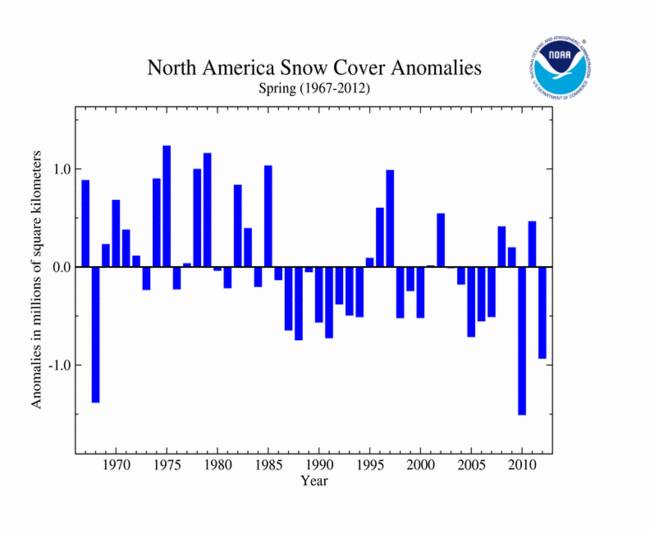
During May 2012, the North American SCE was nearly 0.8 million square km
(310,000 square miles) below average, ranking as the eighth smallest May SCE on
record. According to analysis by Rutgers Global Snow
Lab, the mountainous West of the U.S. had below-average snow cover during
May, as well as most of eastern and central Canada. Above-average snow cover was
observed across the Canadian Rockies and southern Alaska. For spring
(March-May), the North American SCE was the third smallest on record, 0.9
million square km (0.35 million square miles) below average.
Eurasian SCE during May 2012 was 2.67 million square km (1.0 million square
miles) below average, the smallest May snow extent on record for the continent.
This is in sharp contrast to February 2012, when the Eurasian SCE was the third
largest for the month. A warm spring led to rapid snow melt across much of the
continent. According to analysis by Rutgers Global Snow
Lab, below-average snow cover was observed across the Alps, most of Russia,
the Himalayas, and northwestern China. Above-average snow cover was present for
Scandinavia and parts of the Tibetan Plateau. For the spring season (March-May),
the Eurasian SCE was nearly 1.0 million square km (386,000 square miles) below
average, the 12th smallest spring SCE on record for the continent.
As we've mentioned in previous articles, the loss of Arctic sea ice cover is a climatic "tipping point" that is leading to irreversible positive feedbacks, accelerating warming, and leading to increasing climatic chaos.
Which, if no action is taken to quickly reign in CO2 and Methane emissions from fossil-fuel combustion and oil/gas industrial activity, will leave us with a future like this:
I'm sure the people living in Colorado and the western Great Plains are wondering now what is happening, in spite of the deliberate suppression of any real information like this by the corporate media. Now that Denver has had six days of temperatures of 100F+ (including reaching it's all-time high of 105F two days ago) and wildfires are knocking on the door of several cities there. Fire activity in Siberia has also been the worst ever recorded so far this year, and it started early, in mid-April, in it's southern sections.
Temperatures in some towns in western Kansas, Nebraska, Oklahoma, and Colorado, as well as eastern Montana and Wyoming have been between 105-115F (41-45C) over the past week! This after their warmest March and early April ever. Can you imagine what it will be like there in 20-30 years!?
KLUANE UPDATE
We just thought we'd bring you up to date on the activities and progress of the junior member of our staff, Kluane. Our two-year old husky/bernese mountain dog mix who never ceases to amaze us with his rapid learning, enthusiasm, and energy, as he aides in our research, and accompanies us on all our back-country outings.
Kluane bonded with us quickly and well over this past winter, and most of the time stayed close to Mattie and I on our various trips, on skis or foot, as on this hike behind the C.F.R.C. last May, to the top of 1433 metre Konoya pt. He does have a disturbing tendency to chase after and try and herd moose, even cows with calves, but by last January, was at least listening to us, and returning back, when he wanted to do that.
His hardest lesson though was about five weeks ago, in our beloved Eagle River canyon. The river here flows fast and cold from glacial and regular snowmelt. On a day when we planned to do about a 35 KM run on the Iditarod trail from the Eagle R. nature centre, about 10 KM in, he plunged into the cold fast river at Rapids Camp, and was swept to the other side.

He ended up on the opposite shore, unable to swim back to us. The water here is flowing faster than we can run, and is about 2-3C in temperature. After some coaxing from Mattie and I, he walked upstream to a slightly wider, slower section and attempted to swim back to us. The flow was too strong though, and he got caught on a rock near us, but about a metre down from the rocks we were standing on. Fortunately a compassionate bystander saw his plight, and came to our aid. He stepped slightly over the edge whilst I anchored myself down on the rock and grabbed his outstretched arm and pack. He was then able to grab Kluane while I then pulled with all I had to get them up. Which worked, thank goodness. Because if we couldn't have pulled him out, Kluane would have been swept downstream, to meet an uncertain fate.
He learned well though, and in all our river/stream crossings since in different areas, he has been much more careful.
 On a beautiful late afternoon/evening hike several weeks ago, up the very steep Bird Ridge trail, which rises precipitously 1100 metres in 7 km from Turnagain Arm, he was allowed to be completely free. He usually is great on hikes with us, never straying more than a few minutes away, and returning when we call.
Here he is on top of Bird Ridge, making the most of this beautiful and amazing scenery, with it's precipitous slopes. He twice ran down a few hundred metres on these very steep snow-covered slopes chasing ptarmigan, but never lost his footing.
We finally decided he was ready for and worthy of his promotion from intern, to Homer's old position, research assistant, just a few weeks ago, on our foggy Bold Ridge trail hike, which takes you above beautiful clear, blue, Eklutna Lake, source of much Anchorage's power, and water supply.
This hike requires biking in though 9 KM from the Eklutna Lake parking area to the Bold Ridge Trail. He stayed with Mattie and I during this, the hike up Bold Ridge, and for the return, never staying out of our site more than a minute or two. And of course, having to cool off in the snow near the top of our hike at 1400 metres elevation.
Just a week before this, we were greatly impressed with his behaviour on our short overnight 44KM round-trip trek from the CFRC to the sub-Arctic beauty of the Williwaw Lakes area, to the southeast and 1000 metres higher in elevation.
 He again stayed near us at all times, never straying for a moment or two, on the trip up, and back down. While we were camped that night, in that beautiful canyon, with Dall Sheep high up on the south-facing slope, he kept outer-perimeter guard. He also visited and greeted a couple camped about 500 metres away, but not begging or stealing, they really enjoyed meeting him.
Congratulations on your promotion Kluane, and thank you for help, protection, and companionship! Cheers.


 High temperature forecast for Tuesday, July 24, showing the area of extreme heat in the central states. Click on the image for a larger version. Credit: NOAA.
 In recent years there have been many more warm temperature records set or tied in the U.S. compared to cold temperature records, part of a longer-term trend. Credit: Climate Central.


 Despite the extraordinary size of the landslide, which was estimated at a half-mile wide and 5 1/2 miles long, it went virtually unnoticed until air taxi pilot Drake Olson flew over it on July 2. The landslide, which rolled over the glacier, is not very noticeable to the thousands of cruise ship passengers who visit Glacier Bay National Park near Juneau each summer. That is because it is about 12 to 15 miles up the glacier from the bay.


