

Greetings all, forgive us for the delay in writing about my trip to the Malaspina Glacier last month, where your lead editor met with our friends in Ground-Truth Trekking, and joined them in their "Life on Ice" expedition for eight days. http://www.groundtruthtrekking.org/Journeys/LifeOnIce.html
Hig and Erin invited me last summer for part of this trip, in which they hope to document climate change in action, on the largest "Piedmont" glacier in Alaska, spreading out as it does on the coastal plain from it's sources in the high St. Elias mountains inland. I was honoured to accept, since they are such knowledgeable and experienced wilderness-experts and scientists. So after a few months of planning, and then two weeks of feverish preparation, during which I was working in my other position as an operational meteorologist, I left Mattie to hold down the fort at the Chugach Front Research Centre, and boarded Alaska Airlines, to head to Yakutat, on the morning of 21 October. The jumping-off point for the charter flight with Alsek Air, a local outfit in Yakutat, whose pilot Les Hartley was to take me to our meeting site with Hig and Erin, on the beach at "Alder Stream", a wider less-rocky area that at low tide, afforded enough room for Les's Cessna 185 4-seat plane on tundra tires to land and take off safely from the beach.
Hig and Erin's friend Sam Vivang also accompanied me, he is their web-designer, for the Ground Truth Site, and lives in Madison, WI. A town we admire, being as it is, one of the ultimate, and largest, progressive college towns in the country.

Sam and I met in the Juneau airport, and I re-lived to him all my good memories of living there, Juneau is a beautiful place, and culturally, very diverse and interesting. But the often wretched weather and lack of consistent winter snow, led me to move on from there in 2001. I still miss it though.
We made it to Yakutat at 1130, and were immediately met by Alsek Air, and loaded up on Les's Cessna 185. It's a small 4-6 seat plane that can take off and land in very short order, needing only 200 metres or so of a suitable stretch. Sam and I, and our gear were loaded in, and we quickly took off by 1230, and headed to the Alder Stream landing site.

Yakutat, here from the air as we departed, started as a Tlingit village, and is now home to a mixed population, making their living mainly from fishing, tourism, and some government jobs. It has the distinction of being one of the wetter sites in Alaska, receiving 343 cm of precipitation annually. On this day, we actually had dry weather, rare for October, as fall is the wettest season along the Gulf of Alaska.

We only flew at around 300 metres altitude, just very high clouds were present, and winds were relatively light, underneath high pressure ridging, which promised to hold for a few more days. Looking to the north, the huge mass of Hubbard Glacier came into view, up Yakutat Bay, whose source lies far inland in Kluane National Park in Canada, part of which is 5959 metre (19,850 ft) Mt. Logan, the second highest peak in North America.
After just a short 30 min., 55 km flight, we landed on the beach at the Alder Stream site, and quickly unloaded. Our plane to Yakutat from Juneau had been late, and so we arrived at the beach late, as the tide was quickly rising. This left Les with just a few minutes to be on the beach, before having to take off again. We rapidly shuttled our gear and supplies up onto the higher ground behind the beach, and then met with Hig, Erin, and their friend Carl Donohue, a professional wilderness guide and photographer, who had already been with them a week, and would be for at least another.

Here, Sam, on the left, Hig (in the blue vest), and Erin are inspecting the supplies while 2 year old Katmai, and 9 month old baby Lituya relax on the beach. My 34 kg (75lb) pack, in the blue, was awaiting me, which I was not looking forward to. But I had to have my Alpacka pack raft/paddle (3kg), in addition to my best weatherproof tent, clothing, and 9 days of food/fuel, so that was the best I could do.
It was just a short 6.5 km jaunt up to our first camp, where we spent two nights, west up the coastline. Walking along the beach, punctuated by two stream crossings, which Hig ferried us all across with our supplies individually in his larger two-person packraft. This was faster than all of us individually inflating/deflating our rafts, etc...
The ocean here is very powerful and turbulent, as you would expect, being the northern margin of the Gulf of Alaska, where low pressure systems are almost always present. Even though on this day, Friday the 21st of October, winds were light, underneath high pressure ridging, swells coming off the Gulf still produced powerful surf with 1.5-2 metre or more high waves, that break close in to shore, due to the steeply dropping land margin. In fact, we really needed to be on our guard, so we wouldn't get too close to any of these "shore breaks", and get swept off our feet, and into the icy cold 4C (39F) water.

We arrived to our first camp site set about 200 metres back from the beach in a Sitka Spruce forest, around 1730. After quickly setting up camp, we all had dinner, then hung out and made plans for the following few days. We decided to stay there the next day, Saturday, so all of us could get to know each other better, and see that site better. Just another 100 metres or so behind our forest camp, the Sitka Spruce were all dead standing, some kind of flood had killed them in the past few years. Behind that, one of the many streams coming off the Malaspina glacier flowed east-west. After a relaxing night (though the sound of the booming, crashing surf was very loud, even 200 metres in), the next day, Saturday, dawned dry with some sun. After a lazy breakfast, we all decided to go hiking inland, behind camp, and then around to the beach, further west, then back, to camp.
Heading just inland from camp, we quickly came into the dead spruce area. Some of these were very large and had been old, at least 100 years or more, judging by their 30-40 metre heights.
 Hig thinks that multiple flooding episodes led to the demise of this area of trees, which seemed to extend several km up and down along the adjacent stream, which overran it's banks. We surmised warm, high-freezing-level storms in late summer or fall, which would have melted snows and glacier ice on the higher grounds inland, would have been the mechanism to raise the waterways so high here (and which are occurring more frequently now, especially in the last 10 years). From the looks of these standing dead trees, it was no more than five years ago, that this happened.
Heading further inland, toward the banks of the river/stream, we began to get vistas of the high St.Elias mountains, that are the source region for the Malaspina, and other glaciers around.

These 3000-4500 metre peaks are fully encased in permanent snow and glacier ice, and form about a 200 km long NW-SE oriented wall just 15-40 km inland from the Gulf of Alaska. The amount of precipitation that these mountains receive annually is hard to even fathom, easily two to three times the 343 cm that Yakutat receives, most of it snow, above 2000 metres. We hiked around this area for a few hours, while we all talked about the stunning scenery and made our surmises about the causes of all the flooding disturbances we saw. Since Hig has a PhD in geology, and is very interested in meteorology and climatology, our discussions were very interesting and detailed.
 Little two year-old Katmai was having fun just walking around, picking up things, and chattering away, as most two year-olds do. Erin was carrying baby Lituya in a pack behind her back, and she was mostly snoozing in the mild 6C (43F) afternoon. Hig and Erin took alot of precautions and care for their children. They had a large tepee-style tent, which has a wood-stove, the whole setup weighs less than 4 kg packed up. This keeps everyone warm and dry while it's raining, and allows wet clothing/gear to dry out. They had food caches set-up beforehand, and a satellite phone to rely on, in case of any emergencies. So the children were in good hands, and always able to stay warm and dry. And I was too, on the rainiest of my days there, when I would hang out with them, next to that nice little stove!
After a few hours of hiking and beach-combing, as evening began to set in, majestic 5489 metre (18,008 ft) Mt. St. Elias was out in it's full glory. This mountain is rarely climbed, due to it's treacherous weather and highly dangerous avalanches and icefalls, from the tremendous volumes of snow and ice on it. It is the third highest peak north of Mexico, after Denali, and Mt. Logan just to the north, in Canada.

The next day, Sunday the 23rd, was still dry and sunny. It was below freezing that morning, about -2C (28F), judging by the crunchy moss, but not a real deep/hard freeze. We packed up camp, and then set off around 1100 for our next base, Sitkagi "lagoon", a feature that did not exist ten years ago.
The first few km we were able to packraft down the stream behind camp, behind which we had our mountain views. This just took an hour or so. Then on the other side of that, about a km of beach walking on sand/pebbles. Then another stream/packraft crossing. On the other side of that, Hig, Erin, and Carl had come across a large dead sea lion a few days before, and we made sure to make lots of noise, staying all together, before venturing up to it. In case any bears were eating from and guarding it. But we saw none, or even any signs of some.
 We weren't sure of the cause of this large creature's demise, no bullet holes or large wounds were in evidence, so perhaps it was disease, or some other natural cause. We didn't spend too much time here though, just to be on the safe side. From here, it was about another 5 km or so to the "lagoon". The first 3 km were nice beach-walking, like that seen by the dead sea lion, a mix of sand and small rocks. But after that, the sandy beach turned into boulder fields, requiring hopping across/through all of them.
With our heavy packs on, this slowed us down considerably. I felt quite uneasy as well, with my 34 kg pack on, since I had broken my left knee in 2007 by falling onto a boulder near the Gulkana Glacier, in the Alaska Range, and desperately wished not to repeat that experience.

We finally go to Sitkagi at 1730, by which time we only had another hour of light to set up camp. Hig and Carl set out to try and find a suitable camp spot, but were not able to. So we had to set up in an exposed spot at the foot of the "lagoon" just behind logs and rocks thrown up by the last big storms, which you can see, above. A rather precarious spot, to be sure, but we figured we could always move camp the next day, if need be. I was completely soaked in sweat then, from lugging that heavy pack, but some time that evening in Hig and Erin's warm tent by the fire, helped dry me out.
The next day, Monday the 25th of October, the weather began changing. The day started out cloudy with light rain, but not too windy, just 20-40 kph, out of the east. Hig, Erin, and the kids set out to explore the lagoon entrance, and raft further up the lagoon, which extends about a km inland. Sam and I stayed behind to walk along the beach, and then raft a little later, we were hoping the weather would improve a little. It never did, so I put my raft in around 1300, and paddled up and around the lagoon. It was raining lightly with that 20-40 kph east wind. I didn't get too close to the "lagoon" entrance though, high tide for the day was coming through, and making it rather turbulent there with strong currents and eddies. And I did not want to get caught up in one, and possibly swept back out to sea.

What Sitkagi "Lagoon" is, is an opening in the coastline formed by the melting of the glacier from seawater incursions pushed in by high storm tides. It extends back about 1.5 km from the opening, and is growing constantly, as can be seen by the falls of dirt/trees/shrubs at the base of the glacier. The Malaspina glacier is vegetated on its outer margins here because it had been so slow-moving and stable, until relatively recently, but you can see the ice just underneath. Hig thinks that this lagoon is less than ten years old, and that the at the rate the glacier is melting, combined with ever-higher storm tides pushing into the lagoon from stronger, more frequent storms, that it could end up extending back another 40-50 km within 20 years! That would be a huge change to the topography of this coastline.
That night, Monday night, rain became a little heavier and steady. Then, when we awoke Tuesday, we knew we were going to have a situation on our hands. It should be said, that 5 days previously, during the past week, both the European and American long-range numerical weather prediction models forecast a strong front to come into the area on this day, Tuesday, 10/26, with 60-100 kph winds and several cm of rain. I had texted Hig and Erin to that effect the evening before I flew in. And we had been receiving updates from my NWS colleague Dave, by text messages on Hig and Erin's satellite phone, with that forecast holding.

Above, is the surface map for Tuesday afternoon, the 26 of October. A 968 millibar surface low, with an occluded front, lay just to west of the Malaspina area, in the Northern Gulf of Alaska. This is a fairly strong low any time of the year, in this area. Note how "tightly-packed" the lines, or isobars, of pressure are, there is a very strong pressure gradient with a low that deep, meaning that strong winds will be occurring as it approaches, then passes, with strongest winds just ahead of, and with the front.
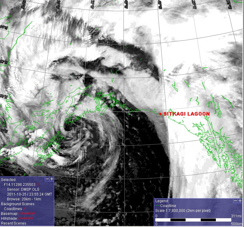
Here is the corrresponding infrared satellite image for this time, you can see the centre of the low just off the southern tip of the Kenai Peninsula, when the frontal band was moving through the Malaspina area. When extra-tropical low pressure systems have that distinct "eye" looking centre, it means that they are very deep and strong, and are not to be taken lightly!
The rain had been steady all the previous night, and the winds, moderate, perhaps 30-50 kph (18-30 mph), nothing our tents couldn't handle. There was a brief let-up, even, in the morning, whilst we had breakfast, between 0800-0900. But by 0930, the storm we had been waiting for/worrying about, came in full-on.
At this time, around 0930, the winds came up easily to 70-90 kph sustained (42-55 mph) with gusts easily as high as 120 kph (75 mph). We all, Carl, Sam, Hig, Erin, the kids, and I rotated duties over the next 7 hours, continually monitoring the tents, staking/tying them down more when some of the tie-outs would come loose with the stronger gusts, and checking the log/rock jam above us, to make sure no high seas were breaking over it, which could flood us. High tide that day was around 1400. If you've never spent a day in a storm, in tents, in strong winds, may you never have to! The sound was deafening. I spent much of the day helping Erin continually brace up the inside of their taller tepee-tent, as strong wind gusts were continually trying to bring it down. The kids were surprisingly calm, considering how worried we all were. Some of the most powerful gusts, that could have been 135 kph (80 mph) were like explosions, and it was all we could do to brace it up, inside. We had to keep that woodstove going too, everyone was getting soaked, coming in and out of the howling wind and heavy rain, bracing their tents. Picture-taking was impossible, in these conditions, we didn't even try, we had other things to worry about! At one point, after some particularly strong and worrisome gusts, Erin asked if I could call the NWS on their satellite phone. I called the NWS Anchorage Forecast Office, where I used to work, and my ex-colleague Bill L., told us to expect 2-3 more hours of the strong winds. We were somewhat relieved, as it was around 1300, and were all getting tired, hoping for the best, that all our tents would survive.
Sure enough, right around 1530, the winds suddenly dropped off, almost to calm! The front was passing, and as it did, in a period of just 10 min., a burst of very heavy rain, then hail, and then snow occurred. Once that ended, we all rushed out relieved. During the strong winds, my Mountain Hardwear 3-season tent, with an extra-heavy duty rain fly, would flatten in the strongest gusts. Yet, it held, one of the poles was bent, but it was in good form. And, only a small 15 cm or so diameter little puddle of water was on the tent floor, blown in from the upwind wall. My sleeping bag and pack were dry! That was a relief. We all had a relaxing evening recovering our energy and warming up by the little woodstove, after our dinner.
 We briefly checked out the beach. It was still raining/misting overall, it looked like the high tide came just up to the foot of the log/rock barrier, above us, but did not crash or flood through, another thing to be thankful for. I was fairly wet though from my times staking out my tent in the foul weather, bending over and working, the wind drove the rain right up inside my layers. All my other ones were damp from the exertion of the last several days. Hence, I went to bed with damp wool base-layers on, which I was not crazy about. But my -9C (15F) down bag, which was dry, kept me warm enough, and by morning, my body-heat had dried out my base layers.
That was also an interesting night, as when the low itself came through, all night long, heavy showers of rain and hail occurred, along with at least three thunderstorms! I slept very fitfully. When these lows, with very cold air aloft in them, are over warmer ocean waters, the airmass in their centres becomes very unstable, and these scattered, "post-frontal" heavy showers/thundershowers occur.

The next day, Wednesday, dawned cloudy and misty, and after all the heavy showers overnight, little drifts of hail and snow were on the ground, in wind-protected areas. The winds were much lighter overnight however, from the west, less than a third the strength of the strong east to southeast winds ahead of the front the afternoon before.
After breakfast and fire warm-up (it was probably only +1C or so, 34F, cold in that damp breezy weather), we all ventured out to see what changes the storm had wrought, in our local landscape. One very prominent thing, is that during rough weather, foam is generated by the higher seas crashing on the rocky shoreline, which marks the previous high tide level. This was in the late morning on Wednesday. Hig and Erin had studied the tides before coming out, and the highest, high tides of the year, were occurring this very week. In fact, the highest, high tide of the whole year, was to be on this afternoon, around 1530. After walking the beach and up to the lagoon entrance, checking out all the changes, logs thrown about, piles of debris, etc.. we came back to camp by 1400. One other thing we noticed, were large ice chunks from the glacier, which fell into the "lagoon", and then were carried out by the strong tidal surges, the previous day.

Carl then announced he was moving his tent, and quickly. He was worried we'd all be flooded out by that highest tide, by the lagoon rising. At first, the rest of us were a little dubious, but sure enough, we could see surges of water coming into the lagoon, and the level was rising quickly!

Carl is a wilderness guide with many years of experience, and his knowledge proved invaluable here. We quickly followed suit and rapidly packed up. Here Hig and Erin are packing up their large tent, and you can see water flooding in, right in front of it. We found some suitable dry clear areas in the spruce woods, just in from this picture, and were able to all get in there, just as the entire area we had been in, went under. Where Carl and I had our tents just flooded about 10-20 cm deep, but it was a little deeper where Hig and Erin's large tent had been. These new camp sites were much better than the old exposed ones, sheltered and wind-protected, we would have been much better off there the previous day, had we been in there! That took us the rest of that day, to re-settle camp. During a quick beach excursion though, as the high tide began going out, we were all thankful for the drier, calm weather, especially when we could watch the sunset!

We had a conference that evening, to come up with our plans for the rest of the trip. Sam and I were to be picked up at the 0930 low-tide that Saturday, the 29th, where we flew in, at the Alder Stream landing site, about 16 km back.
No big storms were expected, but due to the roughness of the beach, and the multiple stream crossings we would have to packraft across, Sam and I decided we should leave the next afternoon, after the high tide, Thursday, and at least get past the very rough 4 km or so boulder-beach section, and camp there. So we would then have a shorter 12 km hike friday to the Alder Stream site, where we could set up a nice camp, and have a relaxed final evening before departing the next day. Carl decided to accompany us back as well, for which we were grateful. He wanted to be flown out with us, and over to Icy Bay, where he would stay for several days, to try and get some good photos of Mt. St. Elias, and all around that amazing area.
That next day, Thursday, started dry, but it began to rain off and on. We all went down to the lagoon entrance in late morning, between showers, and before the high tide, to watch the waves break over the entrance.

This is how Sitkagi "Lagoon" is forming, high tides and surf break through these rocks, and push ever more water into it. This water helps to faster melt the dirt/vegetation-covered glacier ice behind it.
We couldn't stay all day though. We had to pack up, and then get moving by 1600, just after high tide, so we'd have a little more room to walk the boulder-covered beach section, but also arrive to an area to set up camp by 1800, so we'd have a little daylight left. We quickly packed, and were on our way, after saying goodbye to Hig, Erin, Katmai, and Lituya. They also offered to take any extra food we might not need. I jumped at that chance, and was able to offload at least 2 kg. Thus, my pack was much lighter, also from the food I'd eaten the past week. So now, instead of 34.1 kg (75 lbs.), my pack was down to about 27.3 kg (60 lbs.), which made a big difference in how comfortable I was, and how deftly I could manoeuver on the boulders.
As we began packing though, around 1500, steady rain set in, a real downer. Packing everything up in that, made all our gear wet. Then, as we left at 1600, the rain continued. The surf along the beach though was very beautiful.

Although the winds were relatively light, no more than 20-40 kph, large swells in the Gulf were kicking up these 2-3 metre pounders, which were incredibly loud as they boomed into the beach. The rain continued during our two hour march across the boulder beach. It took that long to just go 4 km because hopping across those wet rocks with a heavy pack is not something to do quickly, any accidents, and help will be a long time coming.
It was quite a relief to get through those by 1800, and find a nice wooded site to set up camp. However, it was raining even harder as we unpacked. What followed was my least favourite evening of the trip, setting up camp wet and sweaty (from the exertion of the walk with the heavy pack), then eating a quick meal without the heat of the woodstove from Hig and Erin' tent, got me chilled very quickly, and I had no dry layers to change into. My sleeping bag was still mostly dry, so right after dinner, in damp layers, I crawled into my tent and bag, very dispirited. It took me some time to get to sleep, being so cold/damp. But my down bag and body heat eventually dried me out at least partially, by morning.
The next day, Friday the 28th, dawned dry with just high clouds, and the forecast we'd gotten the day before was for it to stay dry the entire day and that night. What a relief! After a nice dry breakfast, we quickly were packed and on our way by 1030. And the day just kept getting nicer. By 1300, it was entirely sunny, as were all of our moods. We approached the area where the dead sea lion had been, in early afternoon, slowly, in case of bear activity. But, the sea lion had been washed away in the big storm Tuesday. For which we were relieved, one less thing to worry about. We had two quick pack-raft crossings to do, then a nice 4 km section through the woods, where our first camp had been after our arrival. We made good time through those areas.

One interesting thing we noticed, was that a small area of higher ground which separated the beach, from the small river behind, which flowed out from the glacier, had been breached during the Tuesday storm. Another few storms like that (there are always several every fall/winter), and it will become much bigger. Eventually eroding enough that the river mouth may then shift to this area, about 1.5 km upstream from the current one. Which will then allow high tides to enter into the river that much further in, hastening erosion there, etc... You can see how dynamic the terrain here is, and how quickly things can change.
After coming out of the spruce woods, the beach was so littered with debris, and it was high tide. So we had to go through Alder thickets just inland, and cross two streams on logs, which was quite dicey with our heavy packs on. Fortunately Carl helped both Sam and I across these, first by testing them out without his pack on, then by crossing first, and assisting us.

Our last major obstacle of the day was the river crossing just 1.5 km from the Alder Stream landing site. We hit it around 1700 in the waning light of the day. It was a nice gentle current, and fun to get across. But we were eager to deflate the rafts, and head down the beach to find a good camp site. That last part of the hike was quite nice, a real, wide, sandy beach, easy walking with our heavy packs, in the evening sun. We got to the edge of the woods by 1800 and found a nice camp site, had a good dinner in dry weather, and were able to hang out together without worrying about having to stay dry. Carl always had a lightweight portable shelter he'd set up, where we would store our food, well away from camp, and eat our meals in. Then after we ate, we'd join Hig and Erin in their heated tent, to warm up/dry out, and hang out.
It began raining though, after we got in our tents for our final night. I didn't mind, knowing we'd be picked up on the beach tomorrow, and then heading back to the comforts we all take for granted. Les, from Alsek Air was scheduled to fly in at 0930 Saturday morning, at low tide, to pick us up. So we were all up by 0730 and packed by 0900 and on the beach. It was raining, though the visibility was still at least 8-10 km, and the wind 20-40 kph, so we knew Les would make it. Sure enough, exactly at 0930 he buzzed by us, landed, and taxied right up to our feet! Great flying, and great service. It was raining harder as we packed up and got into the plane. Unfortunately, Carl had to stay behind, to be picked up the next day. Les's scheduling was too tight for him to take Carl to Icy Bay. During the short 30 min. flight back to Yakutat, the rain became much heavier, and it was obviously much windier. We got out just in time.
All in all, I had an amazing and interesting time on this trip. Getting to know Hig and Erin better, learning from them about all the different kinds of treks they do, and also talking about the changes we were seeing there, around the Malaspina Glacier. It was also a great pleasure spending time with Carl, and benefitting from his vast wilderness experience, as well as with Sam, who was very eager to learn all about Alaska, in this, his first trip to the state. When Hig and Erin return from their trip next week, and then begin writing it up on their web-site, and putting on videos, I encourage you to check them out, they will be very interesting, and enlightening. For now, they have done a few blog posts, which they've had to give to their visitors, to take out with them.
I'd love to return to this area some day, during a gentler time, with longer days, such as in May or June (April/May/June are the driest months there), and explore more, and see the continuing rapid changes there. And bring Mattie, and our new A.P.R. intern, Kluane. Perhaps you'd like to join us?