
Vast areas throughout western North America are experiencing large areas of various species mortality in coniferous forests. Due to drought-stress/bug kills, all caused by the warming climate. It's been shocking and very sad for your lead author to visit some areas I haven't been in for 10 or more years, when I lived in Montana and worked more throughout the western lower 48 on wildfires, seeing the drastic changes. In southern Utah, east of Cedar City, vast stands of lodgepole pine above 2750 metres elevation (9000 ft) are completely dead, and so far, no new growth has taken their place. Around Stanley, Idaho at 2000 metres elevation (6600 ft.), 1/3 to 1/2 of all the standing timber of the cooler species, subalpine fir, englemann spruce, and lodgepole pine, are also dead. I also observed this near Polebridge, Montana which is on the western edge of Glacier National Park, at elevations of 1000-1830 metres (3300-6000 ft). In addition, huge expanses of the higher-elevation stands of lodgepole pine in central and southern British Columbia have died off over the past 25 years and are standing dead timber/snags now. Further north, into the Yukon, and Kenai Peninsula of Alaska, large expanses of white spruce have also died off and are standing dead, waiting for our increasingly large wildfire seasons to bring them down.

This is because the warming climate has reduced mountain snowpacks overall, hastened their melting in spring, and brought drier summers. Causing drought stress, lowering the ability of many species of trees to resist diseases and fight off bug infestations. In addition, warmer winter temperatures overall, allow more bark-beetles and spruce budworms to survive each season, leading to greater numbers of them, and in longer warm seasons, to even have two breeding/infestation cycles in the trees. All this has taken it's toll, and given that the magnitude of warming will be greatly increasing in the coming decades, we "ain't seen nothin' yet", unfortunately.
In generally ever-moist Southeast Alaska though, it's not drought and bug-kill causing significant tree die-offs in a beautiful and important species, Alaska Yellow-Cedar (which also occurs in large areas on the western slopes of the Cascades of OR/WA and coast ranges of BC), but dwindling winter snowpacks, leading to increasing frost-penetration of the ground when cold spells occur. Give this interesting article a read, we learned quite a bit.
http://www.redorbit.com/news/science/1112467261/yellow-cedar-are-dying-in-alaska-scientists-now-know-why/Yellow-cedar Are Dying In Alaska: Scientists Now Know Why
February 2, 2012

“The cause of tree death, called yellow-cedar decline, is now known to be a form of root freezing that occurs during cold weather in late winter and early spring, but only when snow is not present on the ground,” explains Pacific Northwest Research Station scientist Paul Hennon, co-lead of a synthesis paper recently published in the February issue of the journal BioScience. “When present, snow protects the fine, shallow roots from extreme soil temperatures. The shallow rooting of yellow-cedar, early spring growth, and its unique vulnerability to freezing injury also contribute to this problem.”
Yellow-cedar decline affects about 60 to 70 percent of trees in forests covering 600,000 acres in Alaska and British Columbia. The paper, “Shifting Climate, Altered Niche, and a Dynamic Conservation Strategy for Yellow-Cedar in the North Pacific Coastal Rainforest,” summarizes 30 years of research and offers a framework for a conservation strategy for yellow-cedar in Alaska.
Some key findings include:
- The complex cause of yellow-cedar decline is related to reduced snow, site and stand characteristics, shallow rooting, and the unique vulnerability of the roots to freezing in low temperatures.
- Low snow levels and poor soil drainage lead to impact root injury and the eventual death of yellow-cedar trees. The tree thrives in wet soils, but its tendency to produce shallow roots to access nitrogen on these sites made it more vulnerable when spring snow levels were reduced by climate warming.
- Yellow-cedar health depends on changing snow patterns, thus locations for appropriate conservation and management activities need to follow the shifting snow patterns on the landscape.
- Some responses to shifting climate are expected to be complex and difficult to anticipate. Long-term multidisciplinary research was needed to determine the true role of climate in the health of yellow-cedar and untangle it from other processes and natural cycles in forests.
The yellow-cedar is a slow-growing tree; many are 700 to 1,200 years old. The tree has long been culturally significant to Native Alaskans who use it to make paddles, masks, dishes, and woven items. The wood is also very valuable commercially (for home and boat building) because of its straight grain, durability, and resistance to insects.
Attention is now directed toward a solution to protect and manage yellow-cedar, as coastal Alaska is expected to experience less snow but a persistence of periodic cold weather events in the future.
Scientists are working with partners in the Alaska Region of the Forest Service to use this new information as the framework for a comprehensive conservation strategy for yellow-cedar in Alaska in the context of a changing climate.
“We also have ongoing projects with colleagues in the Tongass National Forest in Alaska on planting and thinning to favor yellow-cedar on suitable habitat,” adds co-lead author and station scientist Dave D’Amore “especially on well-drained productive soils where most of the commercial forestry exits. Silvicultural techniques can be used to nudge the ecological niche of yellow-cedar, making it more competitive on these favorable sites.”
Other coauthors of the synthesis are Paul Schaberg, U.S. Forest Service, Northern Research Station; Dustin Wittwer, U.S. Forest Service, Alaska Region; and Colin Shanley, The Nature Conservancy.
Image Caption: Yellow-cedar in West Chichagof-Yakobi Wilderness Area, a pristine area of coastal Alaska, faces intensive mortality. Photo: Paul Hennon
Source: USDA Forest Service - Pacific Northwest Research Station
Winter snowpacks are dwindling at the lower elevations in Southeast Alaska because there are more frequent, persistent, and stronger high pressure ridging episodes throughout the year, but especially in winter, which move masses of warm air northward from the sub-tropics and mid-latitudes. Which we've described in several previous articles.
With the magnitude of warming expected to triple or quadruple over the next 40 years in Alaska, from that seen over the last 40, due to our increasing CO2 and Methane emissions, we therefore expect these patterns to become even stronger and more persistent. Thus, Yellow-Cedar forests will continue to die off at the lower elevations in Southeast Alaska. And for those of us living in South-Central Alaska, it means stronger and more frequent windstorms will occur throughout the year, with strong, damaging winds and dangerous turbulence for aviation. These will occur more often especially in the fall/winter/spring, along with more freezing rain episodes in winter.
We came across another article lately describing the increasing trends in wildfires expected, as climate warming continues apace. We thought it very worthwhile and worthy of sharing, and have some things to add to it. We've already written several articles here at the A.P.R., presenting our views of this important topic, of which our favourite is this:
Nevertheless, it's always refreshing when we come across research which reinforces our findings, and in this case, we have some real, first-hand experience to discuss. Give this a read, and then we'll provide some commentary.
There Will Be Fire: The 'Carbon Bomb' 'Waiting to Be Ignited'
Scientist: With climate change fires will become more frequent, more intense and harder to stop.
“We are going to see more fire in (the) future, that’s the bottom line.”
“A warmer world’s going to see more fire.”
") photo: John McColgan of the Alaskan
Type I Incident Management Team (Bureau of Land Management, Alaska Fire
Service)This eery warning comes from Mike Flannigan, a
senior research scientist with Natural Resources Canada and professor at the
University of Alberta, at the annual meeting of the American Association for the
Advancement of Science. He says that fires will become more frequent, more
intense and harder to stop.
Flannigan's "conservative estimate" states there would be two to three times
more fire activity in the northern hemisphere by the end of the century.
photo: John McColgan of the Alaskan
Type I Incident Management Team (Bureau of Land Management, Alaska Fire
Service)This eery warning comes from Mike Flannigan, a
senior research scientist with Natural Resources Canada and professor at the
University of Alberta, at the annual meeting of the American Association for the
Advancement of Science. He says that fires will become more frequent, more
intense and harder to stop.
Flannigan's "conservative estimate" states there would be two to three times
more fire activity in the northern hemisphere by the end of the century.
“If a fire is intense, aerial suppression is no longer effective, so even modern fire management agencies, like Canada, the United States and Australia — among the best in the world — will be extremely challenged,” he said.
“I would argue that the standard way of doing fire management will no longer be effective in the future. And that doesn’t even begin to address many parts of the globe where they have traditional fire-suppression approaches, which will be completely overwhelmed."
“So the risk to life and infrastructure is only going to increase under climate change.”
If more wildfires were not bad enough, Flannigan said the warming climate means peat lands, which contain vast stores of carbon, are also more likely to ignite and release greenhouse gas emissions. The emissions could in turn “feed” more warming and more fire.
 When the increased fire from global warming was first detected in 2006,
Johann Goldammer of the Global Fire Monitoring Center at Germany’s Freiburg
University called the northern forest a “carbon bomb”.
When the increased fire from global warming was first detected in 2006,
Johann Goldammer of the Global Fire Monitoring Center at Germany’s Freiburg
University called the northern forest a “carbon bomb”.
About half the world’s soil carbon is locked in northern permafrost and peatland soils, said Merritt Turetsky, an ecologist at Canada’s University of Guelph. This carbon has been accumulating for thousands of years, but fires can release much of this into the atmosphere rapidly, Turetsky said in a release.
photo: John McColgan of the Alaskan
Type I Incident Management Team (Bureau of Land Management, Alaska Fire
Service)This eery warning comes from Mike Flannigan, a
senior research scientist with Natural Resources Canada and professor at the
University of Alberta, at the annual meeting of the American Association for the
Advancement of Science. He says that fires will become more frequent, more
intense and harder to stop.“If a fire is intense, aerial suppression is no longer effective, so even modern fire management agencies, like Canada, the United States and Australia — among the best in the world — will be extremely challenged,” he said.
“I would argue that the standard way of doing fire management will no longer be effective in the future. And that doesn’t even begin to address many parts of the globe where they have traditional fire-suppression approaches, which will be completely overwhelmed."
“So the risk to life and infrastructure is only going to increase under climate change.”
Flannigan added that peat fires are also expected to
dramatically raise greenhouse gas emissions, Postmedia News reports:
If more wildfires were not bad enough, Flannigan said the warming climate means peat lands, which contain vast stores of carbon, are also more likely to ignite and release greenhouse gas emissions. The emissions could in turn “feed” more warming and more fire.
A 1997 fire in Indonesia ignited peat lands that smouldered for months. By the time it was over, Flannigan said the peat fire had released greenhouse gases equal to 20 to 40 per cent of the total worldwide emissions that year from fossil fuels.
Peat fires in the boreal could have the potential to release far more greenhouse gases. “Our peat reserves in Canada, Russia and Alaska dwarf anything in Indonesia,” he said in an interview.
Inter Press Service reports that one researcher referred to the northern forest as
a “carbon bomb” "waiting to be ignited:"

“It’s sitting there waiting to be ignited, and there is already ignition going on,” Goldammer said according to media reports in 2006.
About half the world’s soil carbon is locked in northern permafrost and peatland soils, said Merritt Turetsky, an ecologist at Canada’s University of Guelph. This carbon has been accumulating for thousands of years, but fires can release much of this into the atmosphere rapidly, Turetsky said in a release.
Over the past 10 years, fires are burning far more boreal forest than ever before. Longer snow-free seasons, melting permafrost and rising temperatures are large-scale changes underway in the north, Turetsky and colleagues have found.
Other researchers have shown that the average size of forest fires in the boreal zone of western Canada has tripled since the 1980s. Much of Canada’s vast forest region is approaching a tipping point, warned researchers at the Helmholtz Centre for Environmental Research, Germany’s largest research organisation.
This “drastic change” in normal fire pattern has occurred with a only a small increase in temperatures relative to future temperatures, the German researchers concluded in a study published in the December 2011
We think this last paragraph is the most important. Which is to say, the warming that has already occurred due to our releases of CO2 and Methane over the last 40 years will be 3-4 times greater over the next 4-6 decades, since there isn't, and will not likely be any, concerted global effort to reign emissions in within the next 10 to 20 years (hopefully not any longer than that!).
Your lead author found the preceding article very interesting as well, because I was a witness to the actual site and time that the photo in it was taken. This famous picture of elk seeking refuge in the West Fork of the Bitterroot River whilst fire burns on the slopes behind occurred on the Valley Complex wildfire, near Darby, Montana, in the summer of 2000. I served as an "Incident Meteorologist" from 8/06 to 8/20 that year on that fire, which eventually burned nearly 121,500 hectares (300,000 acres), providing forecasting support for the suppression team. In fact, the very day (and moment) I arrived at the Valley Complex incident base, the fire "blew up", and 29,600 hectares (73,000 acres) burned in 4 hours, which turned out to be the fourth biggest ever "blow up" fire in the Northern Rockies history.

This happened because the fire moved into a large area of dead and downed trees from bug-kills and wind damage, and took off. The sound of the 60 kph inflow winds feeding the monstrous plume, which we could not see the top of from our vantage a few km away (and which we later estimated reached at least 20 km height), sounded like the roar of a freight train as it whipped through camp and into the fire. Truly frightening. This plume spread smoke into the upper troposphere and lower stratosphere, and tracked across the entirety of North America, and out into the Atlantic.
My fourteen days of duty there, working 15-18 hours daily, with poor sleep due to the often thick smoke and noisy, chaotic conditions, left me sick for a month afterward, with a low-grade, nagging bronchitis. The smoke accumulations in the valleys of the region, during this wildfire were often extremely hazardous to health. Visibilities were sometimes as limited to as little as 100-200 metres, and every inhalation felt like a cigarette draw. At one point, after a few exceptionally bad days, I nearly had a panic attack at night, feeling as though I were suffocating or drowning. What calmed me was realising that the other 3000 people working there, and the several thousand residents in the nearby area, were also undergoing the same thing.
I also first noticed something new in the daily weather, that summer of 2000. Which were very low relative humidity minimums by day and recoveries at night on the mid-slopes, which are warmer and drier at night due to drainage flows. They were only recovering to 20%, or even a little less, on many nights after being in the singled digits during the day. I had never seen air-masses that dry in Montana before, when I lived and worked there from 1990-94. So all the dead fuels on the forest floors, and live fuels, were exceedingly dry, and in the right conditions, led to firestorm severity where running crown fires consumed everything, and even fused the soil to hard, glassy surfaces in some areas. Which became very dangerous for flash flooding later. It was at this time I actually realised the climate was changing, and mentioned this to one of the Fire Behaviour Analysts I was working with, who was in agreement. With high pressure ridging episodes becoming stronger overall, as climate warming continues, the subsident, or sinking air in them, has become drier, and this was the first year I realised this.

I also first noticed something new in the daily weather, that summer of 2000. Which were very low relative humidity minimums by day and recoveries at night on the mid-slopes, which are warmer and drier at night due to drainage flows. They were only recovering to 20%, or even a little less, on many nights after being in the singled digits during the day. I had never seen air-masses that dry in Montana before, when I lived and worked there from 1990-94. So all the dead fuels on the forest floors, and live fuels, were exceedingly dry, and in the right conditions, led to firestorm severity where running crown fires consumed everything, and even fused the soil to hard, glassy surfaces in some areas. Which became very dangerous for flash flooding later. It was at this time I actually realised the climate was changing, and mentioned this to one of the Fire Behaviour Analysts I was working with, who was in agreement. With high pressure ridging episodes becoming stronger overall, as climate warming continues, the subsident, or sinking air in them, has become drier, and this was the first year I realised this.

This satellite image from one of those days, 14 August, 2000, shows smoke filling all the valleys in Central Idaho and Western Montana. The Valley Complex was under the very large area of smoke covering the Bitterroot Valley. These conditions, where visibilities in trapped smoke can at times be only a 100 or 200 metres, are exceedingly hazardous. Medical research has established that the finest particulates in heavy smoke, 2.5 micrometers or less in size, and which are the most prevalent, become lodged in the bronchial tubes of the lungs for quite some time, as long as many months. During this time, the heart has to work harder, to pump more oxygen, since the lungs are rendered less efficient, like a dirty air filter. Thus, those with pre-existing respiratory and/or cardiac conditions have an enhanced risk of serious complications. Likewise infants under the age of two, whose lungs are still newly developing, are more sensitive than average, healthy adults.
During my 14 day stretch, there were about 8 of these exceptionally unhealthy days, where the thick smoke from the Valley Complex, and others in the area, was trapped by the diurnal cooling/inversions in the large valleys. Everyone working there, and living there was under great strain. I mention this, because these kind of conditions will be occurring more frequently in fire/smoke-prone areas, in the coming decades. Eastern Washington/Eastern Oregon, Idaho/Western Montana, Southern Oregon/all of California, and the higher elevations of the four-corners states have already been seeing more of this over the past 15 years, with the magnitude of warming that has occurred. Interior Alaska and the Yukon are also highly susceptible to this unfortunate pattern.

In large fire years there over the past decade, such as 2002, 2004-5, and 2009, heavy smoke accumulations plagued the most heavily-populated areas like the Tanana Valley (above, 2004-Fairbanks and environs) and Upper Yukon drainage (Whitehorse area) for days to weeks at a time from June through August.
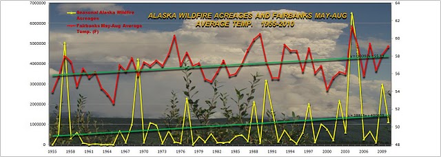
As our plot of Fairbanks summer average temperatures (representing the Alaska Interior) versus annual wildfire acreages show, there is a high correlation between the two, and both show increasing trends. I haven't plotted 2011, it was very low, 117,450 hectares (292,000 acres), much less than the seasonal mean of 368,550 hectares (910,000 acres). What will 2012 bring? Cheers.