IN A TIME OF UNIVERSAL DECEIT...TELLING THE TRUTH BECOMES A REVOLUTIONARY ACT

"Capitalism is the astounding belief that the most wicked of men will do the most wicked of things for the greatest good of everyone." John Maynard Keynes

" Labor is prior to, and independent of, capital; that, in fact, capital is the fruit of labor, and could never have existed if labor had not first existed. Labor is the superior of capital and deserves much the higher consideration" Abraham Lincoln

Wednesday, December 25, 2013

SOLSTICIAL GREETINGS [and] PROMISE KEPT?

            SOLSTICIAL/CHRISTMAS GREETINGS

Winter Solstice in Alaska. A time definitely worth celebrating, meaning 5-6 minutes more sunlight daily within a few weeks, though the coldest temperatures stay with us through February, most years.

Although the sun is low in the sky at our latitude of 61N, just five degrees above the horizon, when it is out, we get beautiful, gentle lighting, when combined with the snow lacing our boreal forest trees.

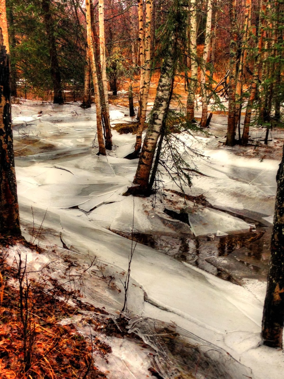
The ice in the creeks builds up from the bottom during our colder spells, and makes for interesting colouring.

Our snowpack by this time is at depths perfect for all our winter recreational needs.

Yet we know with certainty that these conditions are changing rapidly, as we have frequently documented for you before.

We sometimes even fall into a funk, thinking about how potentially dire the future of humanity's place on the Earth really is, in light of the changes that are occurring in the atmospheric/oceanic systems (not just global warming, but ocean acidification is/will prove just as harmful to the global web of life), due to the continuing, and escalating emissions of CO2 and methane, from fossil fuel extraction/combustion, and industrial activity. And the lack of any real attempts to stop them, and transition to sustainable and clean sources of energy.

We are certainly not alone in our assessment. We particularly liked Dahr Jamail's article, summing up the latest scientific assessment, of where we are at globally speaking, with respect to global warming, and its impacts. Because he is of a similar age to your lead editor, and seems to have similar interests/outlooks, this article really resonated with us. Here is a highly alarming excerpt, but the whole article is well worth reading, please do.
http://www.truth-out.org/news/item/20686-are-we-falling-off-the-climate-precipice-scientists-consider-extinction

"Professor Peter Wadhams, a leading Arctic expert at Cambridge University, has been measuring Arctic ice for 40 years, and his findings underscore McPherson’s fears. “The fall-off in ice volume is so fast it is going to bring us to zero very quickly,” Wadhams told a reporter. According to current data, he estimates “with 95% confidence” that the Arctic will have completely ice-free summers by 2018. (U.S. Navy researchers have predicted an ice-free Arctic even earlier -- by 2016.)

British scientist John Nissen, chairman of the Arctic Methane Emergency Group (of which Wadhams is a member), suggests that if the summer sea ice loss passes “the point of no return,” and “catastrophic Arctic methane feedbacks” kick in, we’ll be in an “instant planetary emergency.”

McPherson, Wadham, and Nissen represent just the tip of a melting iceberg of scientists who are now warning us about looming disaster, especially involving Arctic methane releases. In the atmosphere, methane is a greenhouse gas that, on a relatively short-term time scale, is far more destructive than carbon dioxide (CO2). It is 23 times as powerful as CO2 per molecule on a 100-year timescale, 105 times more potent when it comes to heating the planet on a 20-year timescale -- and the Arctic permafrost, onshore and off, is packed with the stuff. “The seabed,” says Wadham, “is offshore permafrost, but is now warming and melting. We are now seeing great plumes of methane bubbling up in the Siberian Sea… millions of square miles where methane cover is being released.”

According to a study just published in Nature Geoscience, twice as much methane as previously thought is being released from the East Siberian Arctic Shelf, a two million square kilometer area off the coast of Northern Siberia. Its researchers found that at least 17 teragrams (one million tons) of methane are being released into the atmosphere each year, whereas a 2010 study had found only seven teragrams heading into the atmosphere.
The day after Nature Geoscience released its study, a group of scientists from Harvard and other leading academic institutions published a report in the Proceedings of the National Academy of Sciences showing that the amount of methane being emitted in the U.S. both from oil and agricultural operations could be 50% greater than previous estimates and 1.5 times higher than estimates of the Environmental Protection Agency.

How serious is the potential global methane build-up? Not all scientists think it’s an immediate threat or even the major threat we face, but Ira Leifer, an atmospheric and marine scientist at the University of California, Santa Barbara, and one of the authors of the recent Arctic Methane study pointed out to me that “the Permian mass extinction that occurred 250 million years ago is related to methane and thought to be the key to what caused the extinction of most species on the planet.” In that extinction episode, it is estimated that 95% of all species were wiped out.

Also known as “The Great Dying,” it was triggered by a massive lava flow in an area of Siberia that led to an increase in global temperatures of six degrees Celsius. That, in turn, caused the melting of frozen methane deposits under the seas. Released into the atmosphere, it caused temperatures to skyrocket further. All of this occurred over a period of approximately 80,000 years.

We are currently in the midst of what scientists consider the sixth mass extinction in planetary history, with between 150 and 200 species going extinct daily, a pace 1,000 times greater than the “natural” or “background” extinction rate. This event may already be comparable to, or even exceed, both the speed and intensity of the Permian mass extinction. The difference being that ours is human caused, isn’t going to take 80,000 years, has so far lasted just a few centuries, and is now gaining speed in a non-linear fashion.

It is possible that, on top of the vast quantities of carbon dioxide from fossil fuels that continue to enter the atmosphere in record amounts yearly, an increased release of methane could signal the beginning of the sort of process that led to the Great Dying. Some scientists fear that the situation is already so serious and so many self-reinforcing feedback loops are already in play that we are in the process of causing our own extinction. Worse yet, some are convinced that it could happen far more quickly than generally believed possible -- even in the course of just the next few decades."

It doesn't have to be this way though. As we have documented before, and in articles like these, researchers world-wide are developing renewable, "carbon-neutral" methods of producing fuels that could be used in existing road and aerial transportation systems, as well as for power generation, in addition to solar and wind power.
"Algae to Crude Oil: Million-Year Natural Process Takes Minutes in the Lab
Dec. 18, 2013Engineers have created a continuous chemical process that produces useful crude oil minutes after they pour in harvested algae -- a verdant green paste with the consistency of pea soup.


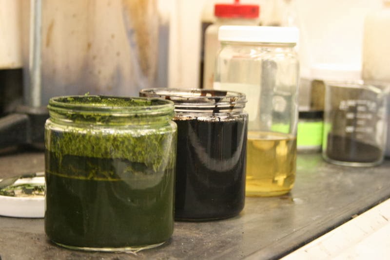
The research by engineers at the Department of Energy's Pacific Northwest National Laboratory was reported recently in the journal Algal Research. A biofuels company, Utah-based Genifuel Corp., has licensed the technology and is working with an industrial partner to build a pilot plant using the technology.

In the PNNL process, a slurry of wet algae is pumped into the front end of a chemical reactor. Once the system is up and running, out comes crude oil in less than an hour, along with water and a byproduct stream of material containing phosphorus that can be recycled to grow more algae.

With additional conventional refining, the crude algae oil is converted into aviation fuel, gasoline or diesel fuel. And the waste water is processed further, yielding burnable gas and substances like potassium and nitrogen, which, along with the cleansed water, can also be recycled to grow more algae.

While algae has long been considered a potential source of biofuel, and several companies have produced algae-based fuels on a research scale, the fuel is projected to be expensive. The PNNL technology harnesses algae's energy potential efficiently and incorporates a number of methods to reduce the cost of producing algae fuel.

"Cost is the big roadblock for algae-based fuel," said Douglas Elliott, the laboratory fellow who led the PNNL team's research. "We believe that the process we've created will help make algae biofuels much more economical."
In addition, there are also methods under development to actually extract CO2 from the atmosphere using various chemical means, which if implemented on a large scale, could actually reduce levels from the dangerous one of 400 ppm now (or the 550 ppm it will be in 2050 if nothing is done!), to 300-320 ppm, where it was around 1900-1920 in a few decades, if done in concert with renewable/clean energy source development. 
http://www.bbc.com/future/story/20121004-fake-trees-to-clean-the-skies/all

All of this could be done on a scale massive enough to prevent catastrophic warming effects, just by the US, if a .025 or .050 FTT (Financial Transaction Tax-a small surcharge on stock trades, etc..) were enacted, combined with a massive reduction in the bloated, immoral defense budget, which is 8 times higher than the next highest country's, China's. In addition, in shifting funding to large scale projects such as these, surplus military personnel, defense companies, etc.. could/would all play a part. And large-scale jobs programmes would provide meaningful, gainful employment to all those in need, in this country.

So there is hope, if we can change our socio-political/economic system(s) in this and other countries, to ones that put the needs of people and the maintenance/protection of the environment, for this and future generations, ahead of short-term corporate profit. It's that simple.

                                              PROMISE KEPT?

Your lead editor has lived and worked in Alaska for over 15 years now. And greatly enjoyed the bulk of the time spent here, first in Juneau, then Fairbanks, and now, near Anchorage. Yet, in all these years, in the back of my mind, I never lost sight of where I left before arriving in Alaska, which was Missoula, Montana. This is where your lead editor lived, for the most part, in 1990-98, at a time of great change in that area, and in me personally. It was then, and still is, an oasis of vibrant, progressive culture, in the "Northern Rockies" of the USA, as it contains the University of Montana, nestled in a mountain setting that provides outstanding outdoor and wilderness recreational possibilities. In a gentler, much drier climate, than here in South-Central Alaska.
http://en.wikipedia.org/wiki/Missoula,_Montana

[view from "Mt. Jumbo", 200m above the valley floor and "Rattlesnake" neighbourhood, where I used to, and will live, again]

With it's interesting history (Ernest Hemingway lived there for a time in the 1930s), and beautiful older (by western USA standards) buildings and neighbourhoods, combined with its relatively pristine mountainous setting, it is a place I instantly fell in love with as soon as I arrived there in 1990, to work in fire weather forecasting. In fact, a very prominent memory of mine is gazing at the fresh October snow in 1992 on 2440m Stuart Peak, and thinking that I'd like to spend the rest of my life there.

After unsuccessfully trying to make a living in the private sector, developing a weather forecast/consulting business (the market just wasn't/isn't big enough there) in 1995-98, I returned to government service by taking a position in Juneau, Alaska.  But an opportunity recently arose to apply for a fire-weather forecasting position in Missoula, and I ended up getting offered the position. Thanks in part to the fact that I had worked there before in the 1990s, and took forestry courses at the University of Montana then.

So the entire staff of the Alaska Progressive Review will be re-locating to Missoula in early March. Assistant editor Mattie, and Research Assistant Kluane, being Alaska born and bred and used to the colder, wetter climate here will need some adjustment. But we will have good trail access for our runs, as we do now. For our nordic skiing needs, we will have to drive a little further. But we will have access to good trail systems. And most importantly, we will be able to access wilderness areas within 30 min. to 3 hrs. driving, in all directions, where we will all be able to enjoy skiing, hiking, running, and backpacking at altitudes of 1800-3000m, in the presence of clear, cold streams that rejuvenate us, and will help keep Kluane and Mattie cool.
[Avalanche Crk. in Glacier NP, Montana USA]
http://www.wilderness.net/NWPS/wildView?WID=360

Just as an example of the kind of culture and forward thinking that exists there, and that we feel to be missing, here in Alaska (other than in isolated instances, due to it's domination by the oil industry and large military installations), is this presentation.
http://missoulian.com/presentation-on-city-ownership-of-mountain-water-co/pdf_f8eea62e-3ad3-11e3-b9f5-001a4bcf887a.html#.UrjdVZmPDT8.email

The mayor and city council of Missoula, with the support of the bulk of the population, has come up with a plan to buy back the privately-owned water company that supplies the city with it's water. To make it a municipal utility, and hence, a non-profit source of clean, affordable water for the population. Because they know in the years/decades ahead, with global warming, the climate of the region is becoming much warmer and drier, especially in summer. And that a privately-owned, profit-driven water company would take advantage of this, and not be willing/able to commit to keeping up with necessary upgrades to maintain adequate supplies. Which is going well against the prevailing policies across much of the rest of the country, where governmental functions and property are often facing privitisation (theft) due to corporate pressure. It appears this project by the city of Missoula is well on it's way to succeeding, in no small part due to its more progressive, educated populace supporting policies like these (Missoula also has been a hotbed of environmental activism over the past 40 years). 

We will continue to offer our unique blend of wilderness advocacy and environmental/progressive reporting, but from our Montana setting. Hence, we'll have to change our name, and a few ideas so far, are "Montana Progressive Standard" or "Rattlesnake Progressive Record". Any other ideas will be happily entertained. Cheers.  

Tuesday, December 3, 2013

A FAIR GO [and] UNCHARTED TERRITORY

                                A FAIR GO

Some years ago, near on to five now, your lead editor was able to live and work in Sydney Australia for a month, and spend some extra time afterward in this beautiful and interesting country.
 

I spent all my spare time touring what I could of the country, whilst meeting wonderful people. In all my time there, I had nothing but good experiences, relating to people from many different backgrounds. Sydney is incredibly diverse culturally, and I met Fijian-Indian Australians, Polish-Australians, Lebanese-Australians, and Indigenous/Aboriginal Australians, in addition to the most prevalent people, descended from the prisoners and settlers from the UK and Ireland.
[Jervis Bay NP, New South Wales, Australia. The clarity of the water here was astounding. eds.]
All citizens of that nation, with a fascinating history. I learned from all of them about that and their way of life and government, becoming very impressed and in admiration of what they have achieved. Not that it is a utopia in a real sense, there still is racism, crime, and all the other problems any "developed" nation has. Yet they have created and are sustaining a more just and fair society than we have in the USA, as we wrote about at the time. With things like a minimum wage, at that time, of 15.38 AUSD (about the same in USD), mandated paid leave for all citizens of four weeks minimum, unemployment insurance that does not expire (and fraud is not a problem there), and of course, universal health care. Thus, we never saw any homeless people in our travels, and crime rates were much lower than what we were used to, living in the USA.

This is all part of their history, as described here:


[Giant 100m tall Blue Gum trees in the Australian Alps at 1300m (4270 ft), near Thredbo, NSW]
http://en.wikipedia.org/wiki/Culture_of_Australia#A_.22fair_go22

A "fair go"[edit]

The belief in a "fair go" is a key part of Australian culture and Australian society.[140] One accepted definition of a "fair go" in this Australian sense is "a chance, an adequate opportunity. Often used to describe a fair and reasonable course of action".[141] The right to "a fair go" has been found to be the most highly rated value on a recent published survey of the opinion of Australian citizens.[142]
This belief sustains bipartisan political support for strong public health and education systems in Australia, as well as legislation such as equal opportunity legislation to ensure people are not excluded from jobs or positions by their race, gender or sexual orientation.[143] This value is frequently cited by politicians who wish to associate themselves or their party with the positive connotations of this notion.[144][145]

There has been ongoing public and political discussion of the place and future of "the fair go" in Australian society. This is especially frequent with reference to economics issues and policies.[146][147][148]

So it was interesting to see this article a few days ago. What a citizen of Australia sees of the USA, and their reaction and analysis. It shows what could be possible here, if enough people would be able to educate themselves. Give it a read, it's well worth the time. If every citizen of the USA who cares about their fellow brothers/sisters in their country did, some great energy and ideas would result!  
http://www.truth-out.org/opinion/item/20248-labor-as-seen-from-down-under-fair-wages-and-decent-benefits-profit-everyone

UNCHARTED TERRITORY

Here in South-Central Alaska, the environment is still reflecting signs of our unusually wet and mild Aug-Oct period, which we discussed earlier.

Even though, and partially because, we returned to more "average" conditions for the month of November. Which we were thankful for, as it allowed us to return to our favourite means of exertion, nordic skiing, by the middle of the month. Two spells of colder than average conditions, with temperatures on the eastern edge of Anchorage reaching -20C to -29C occurred during the month, which caused rapid buildups of ice along the streams emanating from the Chugach Mountains.


PRELIMINARY LOCAL CLIMATOLOGICAL DATA (WS FORM: F-6) , PAGE 2

                                          STATION:  ANCHORAGE AK
                                          MONTH:    NOVEMBER
                                          YEAR:     2013

                                          LATITUDE:   61 10 N
                                          LONGITUDE: 150  2 W

[TEMPERATURE DATA]      [PRECIPITATION DATA]       SYMBOLS USED IN COLUMN 16

AVERAGE MONTHLY: 21.9   TOTAL FOR MONTH:   1.94    1 = FOG OR MIST
DPTR FM NORMAL:  -0.4   DPTR FM NORMAL:    0.78    2 = FOG REDUCING VISIBILITY
HIGHEST:    43 ON  1    GRTST 24HR  1.27 ON 10-10      TO 1/4 MILE OR LESS
LOWEST:     -9 ON 30    
                                            [Source, NOAA/NWS Anchorage, AK, http://pafc.arh.noaa.gov/]
 
But the sheer volume of excessive rainfall that we experienced last August-October, is still "working its way" through the groundwater and streams, causing interesting, and potentially damaging effects. The water-table depth is becoming shallower, and in some areas, surfacing. If this trend continues, some residences in already swampy areas at the base of the Chugach Mtns. will have to be raised, or abandoned, as new spring-fed streams are forming, and expanding.  

In addition, the larger of our streams emanating from the Chugach mountains maintained much higher than average flows through the month of November, which when mixed with the near-average temperatures, and the cold spells, have created interesting effects.

Much greater volumes of ice building up on the larger streams, in some cases forcing vast areas of "overflow" hundreds of meters from their banks. Which freezes solid, in a few areas, to a depth of a metre!
This was our South Fork of Campbell Creek, at the base of the Chugach Mountains, a few days ago. It drains the canyons and mountains of the lower Chugach behind Anchorage, the ones you see from town, which only rise to about 1370-1650m (4500-5400'). But this is a much moister area than Anchorage, receiving at least  double the precipitation amounts than the city.

The ice has built-up around the banks 1-2m, and up from the bottom (anchor ice), while raised up in the middle, a deep 1-2m channel of fast water races through. In early November, before the sudden freeze-up after 11/10, the water here was just 0.5 metre deep.

In an area just downstream from this, in a level spot where the banks were shallower, the water has over-spilled, and created a 200+ metre wide plain of overflow ice, which is 0.3-1.0m thick, as of this writing.  
 
There is a natural gas line which serves as the source for all of the east/northeast sections of Anchorage's heating, including here at the Chugach Front Research Centre. It is being overtaken by the rising water/ice levels.
This is how at looked on 11/30, just five days ago.

Here it is four days later, the ice/water level has risen substantially in this short period!
Needless to say, we are a little nervous. We hope this gasline is engineered to withstand these conditions of becoming encased in solid ice. It does cross the creek under water, so hopefully this is the case. Should repair be required on it, they'd have to cut the fence down, as it may eventually be encased in 1m of solid ice (it's probably about 50-60cm currently).

Everyone we've talked with here has never seen this kind of ice build-up and overflow flooding from these streams before. It has completely buried under solid ice the first portion of a vital connecting trail in our Far North Bicentennial Park, the notorious (for brown bear encounters/maulings) Mellen's Way. Rendering it useless, and unusable, unless you are in hip-waders with crampons on your boots. On our outing there 11/30, your lead editor wore knee-high boots with ice-spikes on, and still nearly got drenched feet. We won't be going back in that area for some time, even though we were fortunate to see an eagle perched out, another thing we've never seen here before in the middle of winter. 

All this icing is creating incredibly beautiful scenery though, in spite of its potential hazard.

Unfortunately, some homes in town are now starting to see the effects of the stream ice build-up, as documented in this article from our local Anchorage Daily News.
http://www.adn.com/2013/12/03/3210815/unusual-winter-floodwater-overflows.html

This description from the article, from a hydrologist describes the problem, and what we have been seeing:

"Chester Creek overflowed its banks Tuesday, sending cold water into the basements and crawl spaces of a handful of homes near Valley of the Moon Park.

The recent cold snap caused water to freeze from the bottom of the creek to the surface, said Jeff Urbanus, a city hydrologist.

With the bottom of the creek bed solid ice, water flowed over the banks in places, he said.

The phenomenon is caused by an uncommon confluence of weather events, he said. Cold air plus warm-season rains -- this is the second-wettest year for Anchorage on record -- made conditions ripe for the phenomenon called "anchor ice," Urbanus said."

Read more here: http://www.adn.com/2013/12/03/3210815/unusual-winter-floodwater-overflows.html#storylink=cpy
 
Combined with our lavish and colourful slow sunrises/sets at the higher latitudes, it is amazing. Since we've never seen this before, we are very curious as to what the rest of the winter, and spring will bring in our area. This is global warming at work, real-time. Cheers.


Wednesday, November 20, 2013

CATEGORY 6

                                                               CATEGORY 6
 
Although  it has been over two weeks now since Super Typhoon Haiyan, possibly the strongest hurricane ever recorded to make landfall, ravaged the central Philippines, recovery is only slowly occurring. The true death toll is still climbing, and may never be fully known.

Many articles have since been written about Haiyan, how unusual it's rapid deepening was, the long duration of it's Super-Typhoon (Category 5 on the Saffir-Simpson hurricane wind scale) status, and it's unusual path. In fact, there are even calls now to revise the Saffir-Simpson scale, in the expectation that as global warming of the oceans and atmosphere continues, tropical storms as strong as Haiyan will become more frequent.
 
The best, most detailed one we've seen was written by Dr. Jeff Masters, an atmospheric scientist who writes informative articles on nationally/globally significant weather/climate events.

http://www.wunderground.com/blog/JeffMasters/comment.html?entrynum=2579

By: Dr. Jeff Masters, 6:25 PM GMT on November 13, 2013
A remarkable warming of the sub-surface Pacific waters east of the Philippines in recent decades, due to a shift in atmospheric circulation patterns and ocean currents that began in the early 1990s, could be responsible for the rapid intensification of Super Typhoon Haiyan. Hurricanes are heat engines, which means they take heat energy out of the ocean, and convert it to kinetic energy in the form of wind. It's well-known that tropical cyclones need surface water temperatures of at least 26.5°C (80°F) to maintain themselves, and that the warmer the water, and the deeper the warm water is, the stronger the storm can get. Deep warm water is important, since as a tropical cyclone tracks over the ocean, it stirs up cooler water from the depths, potentially reducing the intensity of the storm.
 
When both Hurricane Katrina and Hurricane Rita exploded into Category 5 hurricanes as they crossed over a warm eddy in the Gulf of Mexico with a lot of deep, warm water, the concept of the total heat energy available to fuel a hurricane--the Tropical Cyclone Heat Potential (TCHP)--became one that gained wide recognition.
 
The Pacific Ocean east of the Philippines has the largest area of deep, warm water of anywhere on Earth, and these waters have historically fueled the highest incidence of Category 5 storms of anywhere on the planet. Super Typhoon Haiyan tracked over surface waters that were of near-average warmth, 29.5 - 30.5°C (85 - 87°F.) However, the waters at a depth of 100 meters (328 feet) beneath Haiyan during its rapid intensification phase were a huge 3°C above average, according to Professor I-I Lin of the Department of Atmospheric Science at the National Taiwan University.

An analysis by the Japan Meteorological Agency for October showed ocean temperatures 4 - 5°C (7 - 9°F) above average during October (Figure 1). This analysis was from a model. When looking at actual measurements made by the Argo float data in early November, the temperatures in the layer 100 meters below the surface under Haiyan were about 3°C above average, not 4 - 5°C, according to Dr. Lin. As the typhoon stirred this unusually warm water to the surface, the storm was likely able to feed off the heat, allowing Haiyan to intensify into one of the strongest tropical cyclones ever observed.

Figure 1. Modeled departure of temperature from average at a depth of 100 meters in the West Pacific Ocean during October 2013, compared to a 1986 - 2008 average. The track and intensity of Super Typhoon Haiyan are overlaid. Haiyan passed directly over large areas of sub-surface water that were much above average in temperature, which likely contributed to the storm's explosive deepening. While this model showed 4 - 5°C departures from average in October, the actual values were closer to 3°C in early November, according to Argo float data. Image credit: Japan Meteorological Agency.

Why was there such unusually warm sub-surface water?
The sub-surface waters east of the Philippines have warmed dramatically over the past twenty years. According to Pun et al. (2013),
"Recent increase in high tropical cyclone heat potential area in the Western North Pacific Ocean", the depth to where ocean temperatures of at least 26°C (79°F) penetrates has increased by 17% since the early 1990s, and the Tropical Cyclone Heat Potential has increased by 13%. The warm-up is due to an increase in the surface winds blowing across the region--the trade winds--which have caused a southward migration and strengthening of the North Equatorial Current (NEC) and the North Equatorial Counter Current (NECC). The strong trade winds have pushed a large amount of water up against the east coast of the Philippines in the past twenty years, resulting in a rate of sea level rise of 10 mm per year--more than triple the global average of 3.1 mm/yr (Figure 2.) This extra sea level rise contributed to the storm surge damage from Super Typhoon Haiyan. Sea level rise data from Legaspi in the Eastern Philippines shows a rise of about 305 mm (12 inches) since 1949. For comparison, global average sea level rose 7.5" (190 mm) since 1901. Part of the rise along the eastern Philippine coast is from tectonic processes--the subsidence of the Philippine plate under the Eurasian plate--but most of it is due to the stronger trade winds piling up warm water along the coast, and the fact that warmer waters expand, raising sea level.

Figure 2. Trend in sea level from satellite altimeter measurements in 1993 - 2010. Black lines are the Sea Surface Height (SSH) in cm from Rio et al. (2009.) Image credit: Qiu, B., and S. Chen, 2012, "Multidecadal sea level and gyre circulation variability in the northwestern tropical Pacific Ocean", Journal of Physical Oceanography 42.1 (2012): 193-206.

Why have the trade winds sped up?
The surface trade winds in the equatorial Pacific are part of the Walker Circulation--a pattern of rising and sinking air along the Equator that the El Nino/La Nina cycle influences. A strong Walker circulation means there is lower pressure over Indonesia, which pulls in more air at the surface along the Equator from the east, increasing the easterly trade winds. As these trade winds strengthen, they pull surface ocean waters away from South America, allowing cold water to upwell to the surface. This is a La Niña-like situation, which takes heat energy out of the atmosphere, putting it into the ocean, keeping global surface temperatures cooler than they would otherwise be. A weakened Walker circulation is the reverse, resulting in weaker trade winds, and a more El Niño-like situation with higher global surface temperatures. As long as the stronger Walker circulation that has been in place since the early 1990s holds, global surface temperatures should stay cooler than they otherwise would be, prolonging the slow-down in global surface warming that has received much attention this year.


There may also be a greater chance of super typhoons and higher storm surges affecting the Philippines, due to the warmer sub-surface waters and re-arranged ocean currents. A 2013 paper by L’Heureux et al. notes that the climate models predict that the Walker circulation should weaken (a more El Niño-like situation)--the reverse of what has been observed the past twenty years. The researchers took the observed pressure patterns over the Pacific in recent decades and removed the atmospheric response to the El Niño/La Niña cycle. The resulting pattern they found showed a steady strengthening of the Walker circulation, in concert with global rising temperatures. So, are we seeing a failure of the climate models? Or is the recent speed-up of the Walker circulation a decades-long temporary "speed bump" in the climate system? Time will tell. It is worth pointing out that a just-released paper by British and Canadian researchers shows that the global surface temperature rise of the past 15 years has been greatly underestimated. As discussed at realclimate.org, "The reason is the data gaps in the weather station network, especially in the Arctic. If you fill these data gaps using satellite measurements, the warming trend is more than doubled in the widely-used HadCRUT4 data, and the much-discussed “warming pause” has virtually disappeared."I appeared on PBS Newshour last night to discuss the linkages between stronger tropical cyclones and climate change, video here.

References
L’Heureux, Michelle L., Sukyoung Lee, and Bradfield Lyon, 2013,
"Recent multidecadal strengthening of the Walker circulation across the tropical Pacific", Nature Climate Change 3.6 (2013): 571-576.

Pun, Iam‐Fei, I‐I. Lin, and Min‐Hui Lo, 2013,
"Recent increase in high tropical cyclone heat potential area in the Western North Pacific Ocean", Geophysical Research Letters (2013).

Qiu, B., and S. Chen, 2012,
"Multidecadal sea level and gyre circulation variability in the northwestern tropical Pacific Ocean", Journal of Physical Oceanography 42.1 (2012): 193-206.

Jeff Masters

It's clear to us here at the Alaska Progressive Review that all areas of the globe will continue to see stronger, more extreme, and unusual weather patterns and storms. As the excess heat from continually escalating levels of atmospheric CO2 and methane from fossil fuel extraction/combustion affects oceanic-atmospheric system. Things like this, strong, unusually late-season severe weather in the central US.
 
And for us here in mainland Alaska, more chaotic winter weather patterns with greater frequencies of strong wind-storms, and sudden warm-ups accompanied by freezing rain and rain, sometimes followed by heavy snowfalls.  
[source - NOAA/National Weather Service Alaska, 12NOV 2013]
 
This fall over mainland Alaska especially was interesting, as our previous article attested, due to the unprecedented October warmth, which persisted until around the 10th of this month. In fact, on 01 NOV, the APR staff was shocked at what we saw when we ran from the base of the Chugach mountains at 150m elevation, to near 1000m, then back down.  
Heading up past 500m (1640'), it was clear our bears were still active, the trails were completely unfrozen (most years the ground freezes here by early/mid-October), and stream flows much higher than usual, due to the very wet, mild weather S-Central Alaska endured since mid-August.   
 

Even at 762m (2500') there was no snow, and not a trace of frost or ice on the ground. When we finally turned round near 1000m (3280') and headed back down, there was just a few cm of fresh snow from the night before. But what was most shocking to us, was that the ground was completely unfrozen at this elevation, underneath the scant snow. In fact, this area of trail, the one toward Williwaw Lakes, while notoriously swampy and muddy all summer, was often under 10-30 cm of standing water. And was completely un-negotiable in running shoes (albeit with fleece-lined neoprene socks, so my feet were relatively comfortable). This is what forced us to turn back. Every year we've been in these areas above 700m, the ground often begins to freeze even by the fall equinox (9/21). This trail in fact will have to be re-routed, as the last two years of much heavier than normal precipitation have taken it's toll.  
[source - NOAA/National Weather Service Alaska 02NOV 2013]

In fact, in our estimation, the trend of increasing precipitation in South-Central Alaska will continue apace with global warming. As the jet stream continues to shift further north and persist longer over higher latitudes throughout the year. Here at the base of the Chugach mtns., where the Chugach Front Research Centre resides, the water table is very low, and many of the neighbourhoods were built in former swamps/muskegs. We are now seeing the water table rising to the ground here, producing more streams and ponds.

Unfortunately, it looks like some homes in this area will eventually have to be either raised, or abandoned. Cheers.
 

Friday, November 1, 2013

CHANGE YOU CAN BELIEVE IN

                CHANGE YOU CAN BELIEVE IN


The pace and magnitude of Global Warming/Climate Change is faster and greater here in the Arctic than most other areas of the World (as well as in the Antarctic Peninsula, on Antartica, at similar latitudes south of the Equator as Alaska/Scandinavia are north). This is due to our relatively small surface area, combined with the facts that small changes in snow cover extent/duration, and sea ice extent/thickness with resulting milder sea-water temperatures, add great amounts of heat to the Arctic atmosphere. And now, this article estimates it is at it's warmest levels, in some parts, than in the last 120,000 years.
 
 
This has been manifesting itself in many ways, here in Alaska. Two of them are stronger and more frequent fall/winter windstorms, and longer cycles of wet/dry weather, when the jet stream slows. Leaving Alaska under a persistent wet flow, for 4-6 weeks, or a drought, of similar duration when a persistent upper ridge lies over it.
 
Much to our dismay here at the Alaska Progressive review, most of Alaska, including all of South-Central, where Anchorage resides, has been under a wet, mild south-southwest flow aloft, since late August. Giving us 2-3 times our normal rainfall for this period, and this month, making it the warmest October on record. With only a trace of snowfall (when 25-30cm is average for the month) and infrequent frosts. Leaving the ground thawed and muddy, with green grass still present. I don't think anyone has ever seen green grass in Anchorage like this on Halloween!


[credit, NOAA/NWS Alaska]

Alaska has even made national news, as this informative article from Climate Central illustrates:

 
Alaska Roasts During October, Reigniting Wildfire
Now is the time of year when Alaska’s snowpack starts to build and temperatures plunge as the days become shorter and shorter. But this year, October has turned out to be more like September, with rainstorms instead of snowstorms, and some of the mildest temperatures on record for the month, particularly across interior Alaska.
Temperature departures from average during October 2013, showing the relative warmth in Alaska.
Click image to enlarge. Credit: WeatherBell Analytics.

While the warm weather pattern, which has been dominated by a high pressure area in the upper atmosphere, is beginning to change with colder and snowier conditions arriving just in time for Halloween, the above-average temperatures have already carved October 2013’s place in the record books.

According to the National Weather Service in Fairbanks, rain aid in a note on its Facebook page. Temperatures in the 50s at Eielson Air Force Base and Fort Greely were the warmest on record for so late in the fall.
 
The warm weather led to an even more unusual sight for the fall: smoke from an active wildfire. The Mississippi wildfire, which started in May about 70 miles southeast of Fairbanks, flared up again on Oct. 28, when strong winds were blowing and there were record warm temperatures in the lower 60s.
 
According to the Alaska News-Miner newspaper, this is “the latest anyone at the Alaska Fire Service can remember fighting an active Interior fire.” [sadly, unprecedented wildfire behaviour is now becoming the norm over the most vulnerable areas  of the the globe, such as Australia and western North America, as warming/climate shifts accelerate, eds.]
 
In Fairbanks, the monthly average temperature was 36.5°F through Oct. 30, which was nearly 12°F above average for the month, and according to weather.com, ranks among the warmest Octobers on record in the city.
 
The NWS said that in Anchorage, the state’s largest city, the temperature set or tied the mark for the warmest overnight low temperature during 6 of 7 days in the period from October 14-20. It was also the warmest mid-October (11-20) on record there, with an average temperature of 47.9°F, which is close to average for mid-September.
Smoke from the Mississippi wildfire visible in Alaska in late October.
Credit: NWS via Facebook.
 
Studies have shown that sea ice loss can speed warming of parts of the Far North, thereby helping to melt permafrost and unlock the greenhouse gases currently locked in such frozen lands. The Arctic is warming faster than any other area in the Northern Hemisphere, and as the country's only Arctic state, Alaska has been warming rapidly in recent years as well. That has had wide-ranging impacts, including coastal flooding that threatens the viability of some coastal communities, as well as melting permafrost that has wreaked havoc with home foundations in interior Alaska.
 
The coastline of northern Alaska continues to see a trend toward warmer-than-average fall seasons due to the late formation of the sea ice pack. As Arctic sea ice has declined in recent years, it has been slower to build back up close to the shoreline during the fall. That has resulted in above-average temperatures in places like Barrow — the northernmost town in the U.S. — and other locations on the North Slope, since open water allows more heat to escape into the atmosphere than sea ice would have.
 
The NWS said that it was the warmest mid-October on record in Barrow, with an average temperature of 28.4°F from Oct. 11-20 and has been 10°F or more above the 1981-2010 normal every day since October 13th. Through Oct. 30, the monthly temperature was about 8°F above average for the month.
 
However, it appears that Barrow will not break the record for the warmest October, a benchmark that was set just last year.
 

So what has that does that look like here, in South-Central Alaska? Allow us to illustrate, from our daily activities in the beautiful, interesting, and potentially dangerous landscapes here. 

There have been very few clear days here since August. The fall colours in the deciduous birch/aspen/balsam poplar came on later, and were more muted, with the lingering wet mild weather through September. All the creeks and rivers were swollen with continued high runoff from the various mountain ranges.
 
Many of our local running/hiking/biking/ski trails were completely swamped by mid-September from the excess rainfall. Especially here at the base of the Chugach, where groundwater under pressure from the mountains just behind, seeps to the surface in many areas.  
 
The mild wet weather with just a few frosts continued all through October, so that, amazingly, even at 300-400m elevation (1000-1400'), the landscape was snow-free, and the trails only half-frozen. The snow line on the mountains was still only near 900-1000m (3000-3400').   
 
We have been relatively lucky this fall so far, to have only experienced one fairly strong windstorm in the Anchorage area, as opposed to September of 2012, but many weaker ones.  
 
This moderately strong windstorm earlier this week swept through the Anchorage "Bowl", bringing wind gusts as high as 170 kph (106mph) on the slopes of the Chugach (the "Hillside" it is called here, and this part of Anchorage has the most expensive real estate, due to the beautiful views and wilderness proximity). Here at the Chugach Front Research Centre, we estimated our peak wind gusts to be in the 130-150 kph range, based on how our building shook, and the windows rattled. We've been able to calibrate this fairly well, unfortunately. Although we are at the Chugach Base, and not on the slopes, strong wind gusts funnel/whip out of the N. Fk. Campbell Creek Canyon behind us whenever a windstorm has strong winds aligned with it.  A few neighbourhoods nearby were without power from blown-down trees taking down power lines, for 24 hours or so, but better than the 4-5 days for some that happened 9/2012!


These trees came down in our latest storm, across one of our favourite daily-access trails, which all the staff here at the Alaska Progressive Review greatly enjoy running/hiking on.
 
In spite of the often gloomy, dreary weather, there were some sunny breaks where the gentle waning sub-Arctic winter sun would illuminate the landscape in a nice glow. On one of these, we were highly fortunate to run into a relatively rare lynx. She bounded right in front us on one of our favourite trails, and leapt into a birch tree, where she placidly observed us for 5 min., whilst we in our excitement kept circling, angling for the best photo/viewing opportunities. 


We always feel blessed when we can see and appreciate the other large animals that live alongside us in our sub-Arctic environment. In which the ecosystems are complete, unlike in much of the rest of the US, where brown bears and wolves have been exterminated.


With the pace and magnitude of changes occurring here, we are constantly wondering what will be next! Overall though, it has already been shown that when atmospheric CO2 levels were last the same (400ppm) as they are today (from naturally occurring increased volcanism it is thought), the climates in the Arctic were more similar to what we find over the Northwestern US and SErn BC Canada. Meaning that even in winter, the Arctic Ocean was mostly ice-free, the climate of Fairbanks would have been something like that found currently in SErn BC Canada (say Kelowna or Kamloops), and Anchorage would have probably been similar to a place like Port Townsend, Washington, USA.
 
Yet, atmospheric CO2 concentrations by the year 2050 will likely be up to 550 ppm! So not only does the Earth's climate system have to catch up to the much warmer climates that occurred 3 million years ago, but to levels that will be even much warmer! Cheers.