IN A TIME OF UNIVERSAL DECEIT...TELLING THE TRUTH BECOMES A REVOLUTIONARY ACT

"Capitalism is the astounding belief that the most wicked of men will do the most wicked of things for the greatest good of everyone." John Maynard Keynes

" Labor is prior to, and independent of, capital; that, in fact, capital is the fruit of labor, and could never have existed if labor had not first existed. Labor is the superior of capital and deserves much the higher consideration" Abraham Lincoln

Saturday, November 8, 2008

Evo, Si?


While touring around La Paz or other cities on the altiplano, by bus, train, or taxi, I couldn't help but see many billboards like those below, along with painted slogans, or posters, supporting in some way, Evo Morales, the president, and the ruling party, M.A.S., Moviemento as Socialisem (Movement Towards Socialism). This first billboard translates as "Bolivia, United, Grand, and for Everyone", and was for their referendum on his/their policies last summer. Which passed, with 68 percent of the vote, nation-wide.

This sign, below, translates as "Evo of the People", "Because they never abandoned us, the people will never abandon you". Typical political propaganda, you might say, and certainly there is an element of truth to that. No different than political campaigns in any country. But Evo Morales ascedence to the presidency of Bolivia in December, 2005 represented something historic to the 60 percent of that nation who are fully indigenous, since he is also, of the Aymara group, from the town of Oruro, south of La Paz. Much like the election of Barack Obama is seen by the African-American community in this country, but even more so, considering the longer period of repression and powerlessness of Bolivia's indigenous majority. This link gives a good basic biography of him, and his political career. http://en.wikipedia.org/wiki/Evo_Morales


I first became aware of his interesting rise and outlooks when he was elected, and read articles like this: http://www.counterpunch.org/morales09222006.html This was a speech he gave to the U.N. in 2006, in which he provided a clear and understandable outline of what he and his supporters are working for. For me, it made perfect sense, and was greatly admirable. And it was partially for this reason that I wanted to visit Bolivia, because I believe(d) their (MAS) movement had great promise and potential for alleviating long-standing poverty and injustice in that country. And for inspiring movements in other countries of a similar vein, perhaps even in Mexico and the U.S.

Following is the complete text of a letter Pres. Morales wrote to the U.N. on environmental issues, and I couldn't agree more with him.

26 September, 2007 -- Letter from President Evo Morales to the member representatives of the United Nations on the issue of the environment.

"Sister and brother Presidents and Heads of States of the United Nations: The world is suffering from a fever due to climate change, and the disease is the capitalist development model. Whilst over 10,000 years the variation in carbon dioxide (CO2) levels on the planet was approximately 10%, during the last 200 years of industrial development, carbon emissions have increased by 30%. Since 1860, Europe and North America have contributed 70% of the emissions of CO2. 2005 was the hottest year in the last one thousand years on this planet.

Different investigations have demonstrated that out of the 40,170 living species that have been studied, 16,119 are in danger of extinction. One out of eight birds could disappear forever. One out of four mammals is under threat. One out of every three reptiles could cease to exist. Eight out of ten crustaceans and three out of four insects are at risk of extinction. We are living through the sixth crisis of the extinction of living species in the history of the planet and, on this occasion, the rate of extinction is 100 times more accelerated than in geological times.

Faced with this bleak future, transnational interests are proposing to continue as before, and paint the machine green, which is to say, continue with growth and irrational consumerism and inequality, generating more and more profits, without realising that we are currently consuming in one year what the planet produces in one year and three months. Faced with this reality, the solution can not be an environmental make over.

I read in the World Bank report that in order to mitigate the impacts of climate change we need to end subsidies on hydrocarbons, put a price on water and promote private investment in the clean energy sector. Once again they want to apply market recipes and privatisation in order to carry out business as usual, and with it, the same illnesses that these policies produce. The same occurs in the case of biofuels, given that to produce one litre of ethanol you require 12 litres of water. In the same way, to process one ton of agrifuels you need, on average, one hectare of land.

Faced with this situation, we - the indigenous peoples and humble and honest inhabitants of this planet - believe that the time has come to put a stop to this, in order to rediscover our roots, with respect for Mother Earth; with the Pachamama as we call it in the Andes. Today, the indigenous peoples of Latin America and the world have been called upon by history to convert ourselves into the vanguard of the struggle to defend nature and life.

I am convinced that the United Nations Declaration on the Rights of Indigenous Peoples, recently approved after so many years of struggle, needs to pass from paper to reality so that our knowledge and our participation can help to construct a new future of hope for all. Who else but the indigenous people, can point out the path for humanity in order to preserve nature, natural resources and the territories that we have inhabited from ancient times.

We need a profound change of direction, at the world wide level, so as to stop being the condemned of the earth. The countries of the north need to reduce their carbon emissions by between 60% and 80% if we want to avoid a temperature rise of more than 2ยบ in what is left of this century, which would provoke global warming of catastrophic proportions for life and nature.

We need to create a World Environment Organisation which is binding, and which can discipline the World Trade Organisation, which is propelling as towards barbarism. We can no longer continue to talk of growth in Gross National Product without taking into consideration the destruction and wastage of natural resources. We need to adopt an indicator that allows us to consider, in a combined way, the Human Development Index and the Ecological Footprint in order to measure our environmental situation.

We need to apply harsh taxes on the super concentration of wealth, and adopt effective mechanisms for its equitable redistribution. It is not possible that three families can have an income superior to the combined GDP of the 48 poorest countries. We can not talk of equity and social justice whilst this situation continues.

The United States and Europe consume, on average, 8.4 times more that the world average. It is necessary for them to reduce their level of consumption and recognise that all of us are guests on this same land; of the same Pachamama.

I know that change is not easy when an extremely powerful sector has to renounce their extraordinary profits for the planet to survive. In my own country I suffer, with my head held high, this permanent sabotage because we are ending privileges so that everyone can "Live Well" and not better than our counterparts. I know that change in the world is much more difficult than in my country, but I have absolute confidence in human beings, in their capacity to reason, to learn from mistakes, to recuperate their roots, and to change in order to forge a just, diverse, inclusive, equilibrated world in harmony with nature."

Evo Morales Ayma President of the Republic de Bolivia


Unfortunately, his and his government's viewpoints like this are completely at odds with the majority of developed-nations, and our neo-fascist current administration began to actively work against the new Bolivian government in a variety of ways. Which led to the expulsion of the American ambassador, last September. He was accused of funding the separatist groups in the breakaway provinces, groups who were responsible for riots and many fatalities and injuries last Aug. and Sept.
http://shininglight.us/archives/2008/09/bolivia_at_the_abyss.php
Given America's horrible history of funding and supporting murderous right-wing governments over the past century in Latin America, it's hard not to believe at least some of the charges listed by the MAS government. And because the Bush regime has an especially active dislike of Evo M. and Hugo Chavez, (http://en.wikipedia.org/wiki/Hugo_Ch%C3%A1vez) in Venezuela, because they are outspoken about changing their societies unjust and grossly unequal political and economic systems using their nationalized-hydrocarbon wealth, and fighting against U.S. imperialist influence in Latin America (nationalized oil/gas industries set a dangerous precedent, although many developed countries have them, Norway, for example.) All that said though, I never had any problem when I divulged that I was from the U.S. A few people did ask me "what's wrong with your country?", about why Bush was elected twice. I told them our corporate media only shows things favorable to the current government, because they get tax breaks and other benefits. And that most Americans only read and see that information.

Before I did my Illimani climb, the owner of an outdoor store called Tattoo, in Calle Illampu, right down the street my first hotel, Rosario, said there was going to be a huge march/rally on the 20th/21st. He was not happy about it because the streets would be clogged, and it would be bad for business. I forgot about it though, but on the 20th, when I got back early from Illimani, I saw the thousands of people streaming into La Paz for this event. Then, the next day, after I visited at the office of the SNMH, I walked back through downtown, toward my hotel, Hotel Gloria, and came upon this scene.


This is just two blocks down the street from Plaza Murrillo, which I had first visited the day of my arrival in La Paz, and where the Presidential Offices and National Assembly Buildings are. What is all this? Bolivian voters are going to decide in January upon a new constitution that will attempt to meet some of the demands of the hydrocarbon-rich, oligarchical western provinces (the so-called Media Luna, middle crescent), while still trying to move forward with MAS initiatives to re-distribute unused land and allocate some income from natural gas exports toward social spending projects. Evo Morales and members of the MAS initiated and led this march across the entire country, to drum up support for the new constitution. On sunday the 20th of October, with Evo and the MAS officials leading, the hundreds of thousands of marchers streamed into La Paz. Groups of miners, farmers (including coca growers), and indigenous groups from all over the country, and even other countries in South America were part of it. On monday, the 21st, a rally was held in Plaza Murrillo, below, with Evo and other functionaries giving speeches, along with some of the different groups' representatives.


All the streets around Plaza Murrillo were clogged with several hundred thousand people. It was quite an effort getting around, but I managed to go through all the different areas around the plaza, including, at very bottom, right behind the stage where Evo and his people were sitting. At all times, people were courteous and nice to me, even though I stuck out like a sore thumb, being much taller and lighter in color. I have to say, it was very inspiring to see all these people, who had marched for many days, at great effort and expense, all in support of their government. Has that ever happened in the U.S.? After the nightmare of these last 8 GWB years especially, I was feeling very cynical about the political process in general, and seeing this helped reinvigorate me, and my desire to help create a more sane and just government in the U.S.


I wasn't able to understand all the speeches, native spanish speakers tend to be fairly fast, so I was only able to pick up scattered phrases. But most of the speeches seemed to be about the new constitution, working for all of Bolivia, etc.. I did catch a few anti-U.S. references, which I'm sure made sense to them, I wish had been able to understand all of them.

I noticed this man early on, above, in Plaza Murrillo, he seemed to have that energy, or air about him, of leadership and authority. I'm sure you can all remember when you've met someone like that. He actually came up to me and inquired where I was from, since obviously, I was a tourist. With my broken spanish and his few phrases of English, I managed to learn he was from Chapare, on the east side of the altiplano, where it starts to slope down to the rain forest. He was indeed the equivalent of a mayor, in his village, and was with a large group of farmers from there. I gave him my "Yo soy en parti verde Alaska Estados Unidos, Evo, Si!, Hugo, Si!" line, of course which I really mean, and he liked that. We talked for about ten minutes, before his group headed up toward the stage where Evo and the other politicians were. Unfortunately with the strong high-elevation tropical sun, I closed my eyes at the wrong time. Oh well...
During the rally, people were lighting firecrackers and skyrockets, and I have to admit, when these were going off, I got nervous, given the turbulent history in Bolivia, and indeed, in that very plaza.

So what does the future hold for Bolivia's fragile experiment with transforming their country? Every indigenous person I talked with was very much in favor of the MAS government and Evo. One Mestizo man, my guide Alejandro, at Tiwanaku, expressed concern about undue Venezuelan and Cuban influence, as thousands of advisors and medical personnel from both countries have been in Bolivia the last few years. The most pessimistic conversation I had was on the train to Uyuni, with a European woman who's husband worked for a European Union aid agency. She said the expulsion of the American ambassador led to other American interests leaving, and cost the country thousands of jobs. And that the differences between the oligarchical provinces and the MAS government were so great, that a civil war was practically inevitable. That was very depressing to hear, and I certainly hope that will not come to pass. I can only hope that the new Democratic administration in this country will take a more realistic and open-minded stance toward the countries in South America as well. As for me, Evo, Si! I really enjoyed my visit to Bolivia, and all the people I met and talked with were nice, most were hopeful for the future, and many thanked me for visiting. I just wish more of them could visit here!

Friday, November 7, 2008

Illimani


This is Illimani, the beautiful 3-peaked extinct volcano, rising to 21,230 feet, that graces La Paz with her presence, along with a diagram of the route we followed. I had decided when I was planning this trip that I wanted to summit one of the Andean mountains of at least 20,000 feet elevation, and chose Illimani because of its proximity to La Paz, and the interesting descriptions I had read from climbers who had been on it. I went with Bolivian Journeys, a guiding company headed by Marco Souria, who has many years of climbing experience, and has helped glaciologists and climate change researchers in their treks in the high Andes. He told me beforehand this would not be an easy climb. I didn’t doubt him.
My guide was to be Eulogio, who has summited Illimani more than 20 times. He spoke very little English, but with my broken Spanish, I was able to communicate effectively. Although Illimani is only about 25-30 miles from La Paz straight-line distance, it took us 4 hours to get there. We had to wind around an incredibly steep canyon behind La Paz, that had to easily have been at least 7000 feet deep. The road descended to the bottom of it, where it was very warm, then ascended the other side, in steep hairpin curves through three small villages. One of the hazards of the trip is below right, herders with their sheep and llamas, sometimes it took them several minutes to get their flocks off the road.


We arrived at the base village around noon, and had to wait for our porters, to help us haul most of our gear up to the low camp. The base village lies at about 13,000 feet on Illimani’s lower slopes, and women from it hire out to all the guiding companies as porters. The first day, these two teenage sisters, Jimena and Clarita, tied the two 60 lb. bags with our food, tents, and climbing gear to a burro, and led it up to our low camp at 14,500 feet, where they are standing by the tent.


It took us about three hours to hike up to the low camp, it was only about 4 miles from the village, and not too steep of a trail. I had just 35 lb. on my back, extra clothing, some food, a down sleeping bag, and water. So I didn’t feel too bad from the altitude. The low camp was in a large open meadow, right at the base of the mountain. It was a cold and gloomy place during our stay, with occasional showers of snow and sleet, and thunder at times. Amazing to me were the herds of horses, sheep, and llamas that people from the village tended in this inhospitable location. My only negative experience in Bolivia occurred that night. Eulogio warned me to bring everything in the tent at night, but I forgot to bring in my very nice collapsible trekking poles. They were gone in the morning. A little eerie to think of strangers wandering around overnight there around my tent in that gloomy place, stealing things.

The next morning started out cold and gloomy, but as we had breakast, began to turn sunny and inviting. We packed up and were ready to hit the trail at 0900. Our porters this day, to lift our supplies to Campo Alto, the high camp at 18,000 feet, were Jimena, who’s about 16, and her older sister Juanita, who is in her early 20s. They tied up the two 60 lb. bags in blankets, wrapped them around their necks, and followed us behind. The trail initially was not very steep, and I thought, great, if it just slowly winds up the mountain, I’ll be in fine shape. Unfortunately, this was not to be. The trail quickly started ascending a sharp knife-like rock outcropping between glaciers. It was like climbing stairs the whole time, on sharp, sometimes loose rocks, with fatal drop-offs on either side of hundreds of feet.

These pictures, above, are about halfway up to Campo Alto, around 16,000 feet. I quickly realized the effect of the altitude, combined with the weight of my pack and steepness of the trail. At home, hiking or skiing with 35 lbs. on does require additional effort, and slows me down some, but at these altitudes, the effect was magnified. We stopped every hundred feet or so, so I could catch my breath, and took very short, slow steps. Of course even Eulogio couldn’t just run up this, so it took us about five hours to ascend from where the trail steepened at 15,000 feet, to Campo Alto, a map distance of probably only about two or three miles. The views were incredible, the thick, steep glaciers on our sides, and the rocky precipitous slope below tumbling down into the canyon, dotted with distant villages and terraced farms. In the far distance, the skyscrapers of La Paz were visible.

We reached Campo Alto around four in the afternoon, and immediately threw down our packs and rested. 18,000 feet, my new altitude record. But unfortunately, I was so winded from our ascent, I just was not able to fully recover my breath. My breathing continued fast, with my heart racing, and within an hour, I began to come down with the symptoms of the dreaded Soroche, altitude sickness. For those who have never experienced it, it is truly miserable. For me, it was a mind-numbing headache that seemed to press out from my skull through my eyes, and a low-grade nausea, not incapacitating, but enough to prevent me from eating anything, though I was able to drink some hot tea and water. The last time I had felt like that was from a bad case of the flu when I was 21, many years before. The plan had been to set up camp, get to sleep early, then rise at 0200 and summit, so we could get back to camp by early afternoon, in case the daily afternoon convection got too bad. I wasn’t going to descend yet, I thought, maybe with some time and rest, I’d improve. Meanwhile our porters came up with their loads. They ascended the rough, steep, rocky route in their dresses, shawls, and sandals with no socks! And it was about 25F up there at 18,000 feet! Talk about tough, I was highly impressed. They were slower, carrying their heavy loads, but were laughing and joking the whole time.
The views from Campo Alto were incredible, like nothing I had ever seen before. It was worth the money spent, effort, and current misery, just to have seen this incredible place. I did eat a few bites for dinner, which stayed down, then enjoyed the sunset and the views.


You can really see the thick layers of snow/ice accumulation that occur every year during the wet season, which is their summer. In this latitude of the tropics, snow levels are usually around 17-18 thousand feet in summer, 14-15 thousand in winter. But winter is the dry season, so not much falls then. But it did look like to me that there was significant recession on the bottom ends of all the glaciers. When I lived in Juneau, from 1998-2001, the Mendenhall glacier there was in fast recession (and still is), and the freshly exposed rocks on Illimani at the lower edge of the glaciers reminded me of that. And, on older pictures of Illimani, you can see the difference. On this picture, from La Paz, in 1997, the glacial tongues extending down in elevation are much wider, and extend significantly lower. As I mentioned before, the Andean countries of Ecuador,
Peru, and Bolivia are very concerned because climate change modeling suggests that all their glaciers could be gone in 40 to 50 years, which they now rely on for water supply and power generation.
The sunset there has to have been the most beautiful I have ever seen. As the daylight lessened, the lights of La Paz became visible in the far distance, and even further, 100 miles away, the perfect cone of Sajama, the highest peak in Bolivia, at 21,500 feet, was in view. The glaciers above camp and the summit of Illimani were bathed in the orange sunset alpenglow.


These crosses, below, just up the slope from Campo Alto, memorialize three Bolivian guides who died over the past ten years. They died because they were guiding tourists like me who came down with Soroche, who then pressed their guides to continue. The tourists either blacked out or slipped, and took the guides with them on their fatal journey. Eulogio said if I didn’t feel better later than night, there would be no climb. I was not going to argue with that! What followed was very likely the most miserable night I can remember. Bundled in my down bag (the temperature out was probably about 15F, with a stiff breeze), with the headache and nausea, sleep was impossible. When Eulogio awoke at 0200 and asked me how I felt, I said no change, and we decided, there was going to be no summit attempt. So, he went back to sleep, and I tried to, but was not very successful. While lying there in misery, it seemed like every 10 to 15 minutes or so, I heard what at first I thought was thunder. There had been some earlier that day, but after awhile, as these sounds continued, I realized, they were avalanches on the higher slopes of the glacier cap. So, perhaps it was for the best we didn’t summit.

Finally when morning light arrived (not soon enough for me!), we slowly roused ourselves, I had some water and tea, but no food, and we packed camp. We began our descent around 0800, this time Eulogio had me rappel down the steep rocky face, just in case I was too tired and slipped. But I was actually feeling fairly well, just knowing we were descending, I think, gave me a boost. It only took about two hours to get down to 15,000 feet, and by then I felt much better. By the time we got to the low camp site at 14,500 feet, I was able to eat. Another couple hours brought us back to the base village, at 13,000 feet, and by then I was ravenously hungry, and ate a full meal of potatoes the villagers gave us, with canned tuna. I passed out all my chocolates and candy to several small children who materialized from the village. Amazing how just the four thousand foot descent was enough to clear my symptoms and return me to normalcy. Since we didn’t summit, we returned to La Paz a day early, and I visited with the Bolivian Servicio Nacionale de Meteorologia y Hydrologica (Bolivian National Meteorological and Hydrologic Service) the next day, after a good night's sleep in my plush 30.00 hotel.
I met with their Meteorologist in Charge, Senor Felix Trujillo. Their office is in a five-floor building shared with an Air Force branch office and their FAA. Although his English was similar to my Spanish, good for the basics, but difficult to maintain in-depth conversations, we still managed to exchange some useful information.
They have a staff of five meteorologists and are only open Monday-Friday, during the day, since they don’t prepare aviation forecasts (I wasn’t able to ascertain who does them for Bolivia). They do have a doppler radar in La Paz, the only one in the country, and issue severe weather warnings based on it. They also issue flood warnings for the whole country, and prepare water supply forecasts, because they have several large dams producing electricity. I was slowly able to demonstrate our graphical forecast editing procedures, using NWS web-sites. They still write their forecasts manually like we in the NWS used to do before the introduction of the graphical forecasting editing process. Their data displays are very nice and large, very much like our AWIPS system, with panes for satellite, radar, and forecast model images. Since none of the universities in Bolivia have a meteorology program, Sr. Trujillo received his degree in Argentina, and others on their staff from Brazil. A few of their meteorologists have even been to NCEP (National Center For Environmental Prediction), in Washington D.C., for training. The lead forecaster on duty ran through the current weather picture with me, their satellite, radar, and forecast model displays were just as good as any we have in our NWS offices. Sr. Trujillo asked me about climate change issues in Alaska, and I mentioned our melting permafrost and the shrinking summer Arctic Ocean ice. He said their main concern is glacial recession on the high peaks. Bolivia and Peru rely on these for much of their drinking water, and power generation. Modeling suggests that in 40-50 years most, if not all, the glaciers will be gone in these countries. It did look like there was significant shrinkage of glaciers on Illimani, as you can see above, and from what I saw, and of course, the demise of their ski area serves as a stark example. Even though we were handicapped by the language barriers, I felt we had a productive visit, and when my Spanish improves, and I return for another one, I look forward to even better communication.

Thursday, November 6, 2008

Salar de Uyuni/SW Bolivia/chile/Potosi


After my first three days in La Paz spent acclimating to the altitude and getting a feel for how things worked in Bolivia, it was time to move on and see more of the country. I decided well before my arrival to see the Uyuni Salt Flats, the biggest salt lake in the World, and the SW corner of Bolivia, as I had seen amazing and bizarre pictures from there. I was not disappointed. Seemingly, everywhere you look in central La Paz, tour agencies advertise tours of the Salar de Uyuni and SW Bolivia, along with mountain climbs and mountain bike tours. What you will get for your $200.00 for a 3 day 2 night tour will always be the same, unless you really check closely, and pay more money. Which is this, a ride with five other tourists, a guide/driver, and a cook, for eight total, in a 10 to 25 year old Toyota Land Cruiser. Three long driving days spent jammed in the back and center seats was hard on my knees, but well worth it. There were three young Irish tourists, a German woman, and another American and I, along for the ride. First though, I had to hop a jammed local bus from La Paz to Oruro, in central Bolivia, then catch a train from there to Uyuni, the small city on the edge of the salt flat. The bus ride was crowded and long, as to be expected in Latin America. But the train ride was something else entirely. It was clean and modern, with comfortable reclining seats and good food; for the 12 hour ride to Uyuni, the fare was only $20.00!


Setting out from Uyuni in the Land Cruiser, we just took right off over the salt flat at 60 mph. As you can see, it looks like crusty spring “corn” snow, but the surface is as hard-packed as an asphalt road. In the tropical sun at this high altitude, eye protection is essential! It is the biggest salt flat/lake in the World, three times bigger than our Great Salt Lake, and at an elevation of 12,500 feet. There are several small volcanic islands sprinkled around the flat, and after about two hours driving, we came to the most famous, Incahuasi, the cactus-studded rocks. Looking very Arizona-like, with those large cacti, the only clue we had of the high altitude, besides the relatively cool 60 degree day, was the extra effort required to ascend several hundred feet to the top of the island.

What is also amazing about this area is the climate. Although it is still in the tropics, at 20 degrees south latitude, that is far enough from the Equator for decided seasonal differences in temperature to occur. This combined with the altitude produces a climate like no other on Earth. Average high and low temperatures in winter on the salt flats are 45-50, and 8-15, degrees Fahrenheit, respectively! And it can get as cold as -5 to -10F! Summer temperatures are comfortable, 60s by day, around 40 at night. Winter brings the dry season, so snowfall there is rare, the little moisture that comes in summer occurs when convection from the lower elevations to the north and west is forced over the region by the northeasterly trade winds. In the even higher elevations of southwest Bolivia, which we visited on our second and third days, temperatures are even colder, and conditions drier!
Strange and amazing scenes are to be found in SW Bolivia, especially in Eduardo Avaroa National Park, which we toured the second day. Our first night on the salt flat tour was spent in the little village of San Juan de Lipez, near the park, where the accommodations were less than rustic, bordering on extreme. Tiny beds in a tiny, crowded room up dangerous narrow stairs, with the only bathroom (clean though!) at the bottom and around the courtyard. But the food was good, our Bolivian cook provided us with three home-cooked authentic meals daily. I even had Vicuna (the smallest relative of the llama) steak for lunch our first day, which was similar to beef in taste and texture. While we were eating dinner in San Juan de Lipez, about 8 children from the town, between the ages of about 7 and 14 serenaded us with local music using the small flamenco guitar and pipe flutes. They were a little raw, but we appreciated it nonetheless, and of course gave them more than the expected tips. They were very nice kids, and it was great to see them performing for us like that. Before dinner we walked around town, and checked out their local livestock, llamas and alpacas. We also were encouraged to take a tour of mummified remains in a weird open-air rock graveyard. Said to be from the indigenous people there 800 years ago. I didn't take pictures, thinking it not appropriate. But there were about 20 little rock crypts, many of which did indeed have small mummies in them, mostly bones, some skin, clad in disintegrating wool clothing. For these views, we paid 5 Bolivianos (80 cents). Interesting, but strange.


The next day we took off early and headed in to the park. These are some of the things we saw.


The flamingoes in the picture on the top, left, were found in several lakes around the region. They live year-round there, eating algae, even though the lakes partially freeze every night. The strange rock, below this, was formed by eolian processes, i.e., by the strong prevailing winds in the region blowing sand, which eroded the softer rock. This rock was on a plain at 15,500 feet, and on our day, a strong northeast wind of 35-45 mph was blowing, and it was about 45 degrees. The red lake, upper left, is Laguna Colorado, our destination on day two. The amazing red color of the lake is from algae, and there were thousands of flamingoes on it, truly a strange site, the more so because the wind was even stronger, than up the road where the eolian rock was. All the salt flat tours spend the night at the Laguna Colorado camp, which is a collection of cabins with 8 beds, one cabin per land cruiser. The accommodations were just as rustic as the night before, but comfortable. As it got down to about 15F that night, and the cabins are unheated, we had all been warned to bring warm clothing and down sleeping bags, and were glad we did.


We were awoken early the morning of the third day, at 0430, that we could leave at 0500 so as to arrive at the geyser area of the park by sunrise, around 0600. This unusual steam geyser was only lukewarm to the touch! There were several others in the vicinity as well. After breakfast at a lodge there with a nice hot spring to soak in (it was still just 20F outside), we headed south and west toward the Chilean border, over a 16,500 foot pass. On the other side of that pass, we came to Laguna Verde, above right, the green lake. It has an otherworldy appearance, as you can see, and there were flamingoes in it. This lake lies at about 14,500 feet.


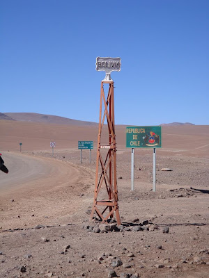
We made a brief foray to the Chilean border, to drop off one our riders, so she could catch a bus into that country. I ran briefly across the border, there being no guards, just so I can say I set foot in it. I have a strong attraction to that country, and it is next on my list to visit. Partially because I remember the terrible history there from the 1970s, on. When I was 9, in 4th grade, we all once a week, had to bring a newspaper article in and talk about it in front of the class. I'll never forget what mine was. It was a very small two paragraph story on the corner of the front page of the San Diego Union, "Coup in Chile", dated September 12, 1973. It just gave a brief description of the previous day's events there, which you can read about in my "Is it 9/11 already?" post. My Mom knew more of the story, since she was an activist in a very left-wing party then. But she didn't explain it all to me, I was only 9, and wouldn't fully have fully understood. I want to talk to people in Chile and see what their experiences were then, and see the changes that have occurred since, which are great. Their current "center-left" President, http://en.wikipedia.org/wiki/Michelle_Bachelet, actually lost her father in the 1973 coup, and she and her mother were tortured by the fascists. Our support of that coup marks one of the darkest events/actions in modern American history.

After our stop at the Chilean border, we made the long, 8 hour ride back to Uyuni, over more windy, narrow, mountain gravel/sand roads. By the time we got back to Uyuni, we were all sore of knees, tired, dusty, and parched, but still stunned by the amazing scenery, something none of us will ever forget.
Next up on the itinerary was a side trip over to Potosi, the old mining city, which at 14,000 feet, is listed in the guidebooks as the highest city in the World. With a population of 200,000, I didn’t doubt it. The bus ride from Uyuni to Potosi was a classic Bolivian journey, 9 hours over a mix of paved and dirt road winding up and down passes as high as 16,000 feet, with two stops in small villages, to give us a chance to stretch our legs, get a snack, and most important, find a restroom. Potosi is dominated by Cerro Rico, an innocuous looking 16,500 foot “hill”. But this hill has a terrible and amazing history. Out of it came untold billions of dollars in silver, which financed the Spanish empire from 1550 until Bolivia’s independence in 1821. It is estimated that 500,000 to one million indigenous people died in the mines during those years, when they were forced by the Spaniards to work in them. Thousands of miners continue to work the shafts in Cerro Rico, though it is not an easy living.


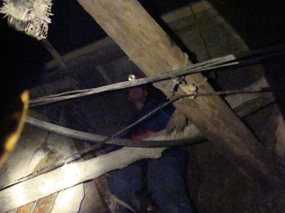
Before reaching the mine, we had to suit up in protective gear, and buy some supplies to give to the miners, dynamite (anyone in Potosi can just buy it in a store!), snacks, and a bag of coca leaves. The mine entrance, as you can see, is fairly small, and after disbursing our gifts to the miners, we headed in. We walked for almost a kilometer in, it was cool, and damp, with standing water in many areas. Strange stalactites of salts and minerals were hanging off the ceilings as well, some of the reddish ones we saw were composed of sulfuric acid! Sometimes the shafts were only 4-5 feet high, so this is definitely not something for the claustrophobic. It gave me a good idea of what those miners have to go through every day, and our guide said most of them can only end up working in there for 10-15 years, before health problems force them to find other work.


I left Potosi that night, the only bus back to La Paz is a 10 hour overnight trip. This went fairly well, I was able to sleep most of the way, and got back to La Paz in good shape. Because the next day, the centerpiece of my entire trip was to begin.