IN A TIME OF UNIVERSAL DECEIT...TELLING THE TRUTH BECOMES A REVOLUTIONARY ACT

"Capitalism is the astounding belief that the most wicked of men will do the most wicked of things for the greatest good of everyone." John Maynard Keynes

" Labor is prior to, and independent of, capital; that, in fact, capital is the fruit of labor, and could never have existed if labor had not first existed. Labor is the superior of capital and deserves much the higher consideration" Abraham Lincoln

Thursday, June 28, 2012

DAYS OF FUKUSHIMA PAST? [and] HEAT IS ON + KLUANE UPDATE

                       DAYS OF FUKUSHIMA PAST?

The tragedy of the earthquake/tsunami in Japan 15 months ago, followed quickly by the meltdown of no less than three nuclear reactors in the Fukushima Dai-ichi complex has fallen completely off the radar of the global corporate media. However, there are still significant hazards occurring there, which could affect everyone in the Northern Hemisphere, not just those in Japan, or along the west coast of North America, including Alaska.
This is because there is one particular building in the Fukushima reactor 4 complex that is of great concern. It is a building containing spent nuclear fuel rods that are still "hot" and must be kept from overheating, or they will catch fire and create a monstrous plume of lethal radioactivity, which scientists now say, if it were to occur, and spread to the other pools in the Fukushima reactor complex, could be 85 times worse than the radionuclide/radiation releases that occurred from Chernobyl, in the Ukraine in 1986. But you are not hearing about it in the corporate media. And the earthquake hazard there is just as great now as before the monstrous magnitude 9.0 quake last year, which would lead to this worst-case scenario.

http://www.alternet.org/story/155283/the_worst_yet_to_come_why_nuclear_experts_are_calling_fukushima_a_ticking_time-bomb?page=entire

The Worst Yet to Come? Why Nuclear Experts Are Calling Fukushima a Ticking Time-Bomb
Experts say acknowledging the threat would call into question the safety of dozens of identically designed nuclear power plants in the U.S.

Photo Credit: Shutterstock/ Sergey150770
More than a year after the triple meltdown at the Fukushima Daiichi power plant, the Japanese government, Tokyo Electric Power Company (Tepco) and the U.S. Nuclear Regulatory Commission (NRC) present similar assurances of the site's current state: challenges remain but everything is under control. The worst is over.
But nuclear waste experts say the Japanese are literally playing with fire in the way nuclear spent fuel continues to be stored onsite, especially in reactor 4, which contains the most irradiated fuel -- 10 times the deadly cesium-137 released during the 1986 Chernobyl nuclear accident. These experts also charge that the NRC is letting this threat fester because acknowledging it would call into question safety at dozens of identically designed nuclear power plants around the U.S., which contain exceedingly higher volumes of spent fuel in similar elevated pools outside of reinforced containment.

Reactor 4: The Most Imminent Threat
The spent fuel in the hobbled unit 4 at Fukushima Daiichi not only sits in an elevated pool outside the reactor core's reinforced containment, in a high-consequence earthquake zone adjacent to the ocean -- just as nearly all the spent fuel at the nuclear site is stored -- but it's also open to the elements because a hydrogen explosion blew off the roof during the early days of the accident and sent the building into a list.
Alarmed by the precarious nature of spent fuel storage during his recent tour of the Fukushima Daiichi site, Sen. Ron Wyden, D-Oregon, subsequently fired off letters to Secretary of State Hillary Clinton, Secretary of Energy Steven Chu, NRC Chairman Gregory Jaczko and Japanese ambassador to the U.S. Ichiro Fujisaki. He implored all parties to work together and with the international community to address this situation as swiftly as possible.

A press release issued after his visit said that Wyden, a senior member of the U.S. Senate Committee on Energy and Natural Resources who is highly experienced with nuclear waste storage issues, believes the situation is "worse than reported," with "spent fuel rods currently being stored in unsound structures immediately adjacent to the ocean." The press release also noted the structures' high susceptibility to earthquakes and that "the only protection from a future tsunami, Wyden observed, is a small, makeshift sea wall erected out of bags of rock."

As opposed to units 1-3 at Fukushima Daiichi, where the meltdowns occurred, unit 4's reactor core, like units 5 and 6, was not in operation when the earthquake struck last year. But unlike units 5 and 6, it had recently uploaded highly radioactive spent fuel into its storage pool before the disaster struck.
Robert Alvarez, a nuclear waste expert and former senior adviser to the Secretary of Energy during the Clinton administration, has crunched the numbers pertaining to the spent fuel pool threat based on information he obtained from sources such as Tepco, the U.S. Department of Energy, Japanese academic presentations and the Institute of Nuclear Power Operations (INPO), the U.S. organization created by the nuclear power industry in the wake of the 1979 Three Mile Island accident.

What he found, which has been corroborated by other experts interviewed by AlterNet, is an astounding amount of vulnerably stored spent fuel, also known as irradiated fuel, at the Fukushima Daiichi site. His immediate focus is on the fuel stored in the damaged unit 4's pool, which contains the single largest inventory of highly radioactive spent fuel of any of the pools in the damaged reactors.

Alvarez warns that if there is another large earthquake or event that causes this pool to drain of water, which keeps the fuel rods from overheating and igniting, it could cause a catastrophic fire releasing 10 times more cesium-137 than was released at Chernobyl.

That scenario alone would cause an unprecedented spread of radioactivity, far greater than what occurred last year, depositing enormous amounts of radioactive materials over thousands of miles and causing the evacuation of Tokyo.

Nuclear experts noted that other lethal radioactive isotopes would also be released in such a fire, but that the focus is on cesium-137 because it easily volatilizes and spreads pervasively, as it did during the Chernobyl accident and again after the disaster at Fukushima Daiichi last year.

With a half-life of 30 years, it gives off penetrating radiation as it decays and can remain dangerous for hundreds of years. Once in the environment, it mimics potassium as it accumulates in the food chain; when it enters the human body, about 75 percent lodges in muscle tissue, including the heart.

The Threat Not Just to Japan But to the U.S. and the World

An even more catastrophic worst-case scenario follows that a fire in the pool at unit 4 could then spread, igniting the irradiated fuel throughout the nuclear site and releasing an amount of cesium-137 equaling a doomsday-like load, roughly 85 times more than the release at Chernobyl.

It's a scenario that would literally threaten Japan's annihilation and civilization at large, with widespread worldwide environmental radioactive contamination.

"Japan would suffer the worst, but it would be a global catastrophe," said Kevin Kamps, nuclear waste expert at the watchdog group Beyond Nuclear. "It already is, it already has been, but it would dwarf what's already happened."

Kamps noted that these pool fires were the beginning of the worst-case analysis envisioned by the Japanese government in the early days of the disaster, as reported by the New York Times in February.

"Not only three reactor meltdowns but seven pool fires at Fukushima Daiichi," Kamps said. "If the site had to be abandoned by all workers, then everything would come loose. The end result of that was the evacuation of Tokyo."

In an interview with AlterNet, Alvarez, who is a senior scholar at the Institute for Policy Studies, said that the Japanese government, Tepco and the U.S. NRC are reluctant to say anything publicly about the spent fuel threat because "there is a tendency to want to provide reassurance that everything is fine."

He was quick to note, "The cores are still a problem, make no mistake, and there will be some very bad things happening if they don't maintain their temperatures at some sort of stable level and make sure this stuff doesn't eat down through the concrete mats."

But he said that privately "they're probably more scared shitless about the pools than they are about the cores. They know they're really risky and dangerous."

AlterNet asked the NRC if it is concerned about the vulnerability of the spent fuel at Fukushima Daiichi and what, if anything, it had expressed to the Japanese government and Tepco on the matter.
"All the available information continues to show the situation at Fukushima Dai-ichi is stable, both for the reactors and the spent fuel pools," NRC spokesman Scott Burnell replied via email. "The available information indicates that Spent Fuel Pool #4 has been reinforced."

But nuclear experts, including Arnie Gundersen, a former nuclear industry senior vice president who coordinated projects at 70 U.S. nuclear power plants, and warned days after the disaster at Fukushima last year of a "Chernobyl on steroids" if the spent fuel pools were to ignite, strongly disagreed with this assessment.

"It is true that in May and June the floor of the U4 SFP [spent fuel pool] was 'reinforced,' but not as strong as it was originally," Gundersen noted in an email to AlterNet. "The entire building however has not been reinforced and is damaged by the explosion in both 4 and 3. So structurally U4 is not as strong as its original design required."

Gundersen, who is chief engineer at the consulting firm Fairewinds Associates, added that the spent fuel pool at unit 4 "remains the single biggest concern since about the second week of the accident. It can still create 'Chernobyl on steroids.'"

Alvarez said that even if the unit 4 structure has been tentatively stabilized, it doesn't change the fact "it sits in a structurally damaged building, is about 100 feet above the ground and is exposed to the atmosphere, in a high-consequence earthquake zone."

He also said that the urgency of the situation is underscored by the ongoing seismic activity around northeast Japan, in which 13 earthquakes of magnitude 4.0 to 5.7 have occurred off the northeast coast of Honshu between April 14 and April 17.

"This has been the norm since 3/11/11 and larger quakes are expected closer to the power plant," Alvarez added.

A recent study published in the journal Solid Earth, which used data from over 6,000 earthquakes, confirms the expectation of larger quakes in closer proximity to the Fukushima Daiichi site. In part, this conclusion is predicated on the discovery that the earthquake that initiated last year's disaster caused a seismic fault close to the nuclear plant to reactivate.

"There are a few active faults in the nuclear power plant area, and our results show the existence of similar structural anomalies under both the Iwaki and the Fukushima Daiichi areas," lead researcher Dapeng Zhao, a geophysics professor at Japan's Tohoku University, said in a press release. "Given that a large earthquake occurred in Iwaki not long ago, we think it is possible for a similarly strong earthquake to happen in Fukushima."

AlterNet asked Sen. Wyden if he considers the spent fuel at Fukushima Daiichi a national security threat.

In a statement released by his office, Wyden replied, "The radiation caused by the failure of the spent fuel pools in the event of another earthquake could reach the West Coast within days. That absolutely makes the safe containment and protection of this spent fuel a security issue for the United States."
Alvarez agrees, saying, "My major concern is that this effort to get that spent fuel out of there is not something you should be doing casually and taking your time on."

Yet Tepco's current plans are to hold the majority of this spent fuel onsite for years in the same elevated, uncontained storage pools, only transferring some of the fuel into more secure, hardened dry casks when the common pool reaches capacity.

For the moment, though, and for the foreseeable future -- unless the international community substantively comes to Japan's aid -- Tepco couldn't transfer the irradiated fuel from the damaged reactor units into dry cask storage even if it wanted to because the equipment to do so, such as the crane support infrastructure, was destroyed during the initial disaster.

"That's kind of shocking," said Paul Gunter of Beyond Nuclear. "But that's why we're still sitting on this gamble that there won't be another earthquake that could topple a very precarious unit 4."
Gunter is concerned that even a minor earthquake or a subsidence in the earth under unit 4 could cause its collapse.

"I think we're all on pins and needles every day with regard to unit 4," he said. "I mean there's any number of things that could happen. Nobody really knows."

Gunter added, "Right now its seismic rating should be zero."

Alvarez echoed Wyden's letters to the Japanese ambassador and U.S. officials.

"It really requires a major effort," he said. "The United States and other countries should begin to get involved and try to help the Japanese government to expedite the removal of that spent fuel and to put it into dry, hardened storage as soon as possible."

Same Spent Fuel Pool Designs at Dozens of U.S. Nuclear Sites

So why isn't the NRC and the Obama administration doing more to shed light on the extreme vulnerability of these irradiated fuel pools at Fukushima Daiichi, which threaten not only Japan but the U.S. and the world?

Nuclear waste experts say it would expose the fact that the same design flaw lies in wait -- and has been for decades -- at dozens of U.S. nuclear facilities. And that's not something the NRC, which is routinely accused of promoting the nuclear industry rather than adequately regulating it, nor the pro-nuclear Obama administration, want to broadcast to the American public.

"The U.S. government right now is engaged in its own kabuki theatre to protect the U.S. industry from the real costs of the lessons at Fukushima," Gunter said. "The NRC and its champions in the White House and on Capitol Hill are looking to obfuscate the real threats and the necessary policy changes to address the risk."

There are 31 G.E. Mark I and Mark II boiling water reactors (BRWs) in the U.S., the type used at Fukushima. All of these reactors, which comprise just under a third of all nuclear reactors in the U.S., store their spent fuel in elevated pools located outside the primary, or reinforced, containment that protects the reactor core. Thus, the outside structure, the building ostensibly protecting the storage pools, is much weaker, in most cases about as sturdy, experts describe in interviews with AlterNet, as a structure one would find housing a car dealership or a Wal-Mart.

Not what Americans might expect to find safeguarding nuclear material that is more highly radioactive than what resides in the reactor core.

The outer containments surrounding these spent fuel pools in these U.S. reactors patently fail to meet the NRC's own "defense in-depth" nuclear safety requirements.

But these reactors don't merely suffer from the same storage design flaw as those at Fukushima Daiichi.

In the U.S., the nuclear industry has been allowed to store incredible volumes of spent fuel for decades in high-density pools that were not only originally designed to retain about one-fourth or one-fifth of what they now hold but were intended to be temporary storage facilities. No more than five years. That was before the idea of reprocessing irradiated fuel in this country failed to gain a foothold over 30 years ago. Once that happened, starting in the early 1980s, the NRC allowed high-density storage in fuel pools on the false assumption that a high-level waste repository would be opened by 1998. But subsequent efforts to gain support for storing nuclear waste at Yucca Mountain in Nevada have also been scrapped.

More recently, the NRC arbitrarily concluded these pools could store this spent fuel safely for 120 years.
"Our pools are more crammed to the gills than the unit 4 pool at Fukushima Daiichi, much more so," noted Kamps of Beyond Nuclear. "It's kind of like a very thick forest that's waiting for a wildfire. It would take extraordinary measures to prevent nuclear chain reactions in our pools because the waste is so closely packed in there."

Experts say the only near-term answer to better protect our nation's existing spent nuclear fuel is dry cask storage. But there's one catch: the nuclear industry doesn't want to incur the expense, which is about $1 million per cask.

"So now they're stuck," said Alvarez, "The NRC has made this policy decision, which the industry is very violently opposed to changing because it saves them a ton of money. And if they have to go to dry hardened storage onsite, they're going to have to fork over several hundred million dollars per reactor to do this."

He also pointed out that the contents of the nine dry casks at the Fukushima Daiichi site were undamaged by the disaster.

"Nobody paid much attention to that fact," Alvarez said. "I've never seen anybody at Tepco or anyone [at the NRC or in the nuclear industry] saying, 'Well, thank god for the dry casks. They were untouched.' They don't say a word about it."

The NRC declined to comment directly to accusations it's reluctant to draw attention to the spent fuel vulnerability at Fukushima Daiichi because it would bring more awareness to the dangers of irradiated storage here in the U.S. But the agency did respond to a question about what it has done to address the vulnerability of spent nuclear fuel storage at U.S. nuclear sites with the Mark I and II designs.

"All U.S. spent nuclear fuel is stored safely and securely, regardless of reactor type," NRC spokesman Burnell replied in an email. "Every spent fuel pool is an inherently robust combination of reinforced concrete and steel, capable of safely withstanding the same type and variety of severe events that reactors are designed for."

He continued, "After 9/11, the NRC required U.S. nuclear power plants to obtain additional equipment for maintaining reactor and spent fuel pool safety in the event of any situation that could disable large areas of the plant. This 'B5b' equipment and related procedures include ensuring spent fuel pools have adequate water levels. The B5b measures are in place at every U.S. plant and have been inspected multiple times, including shortly after the accident at Fukushima.

"The NRC continues to conclude the combination of installed safety equipment and B5b measures can protect the public if extreme events impact a U.S. nuclear power plant."

But nuclear experts told AlterNet that the majority of Burnell's response could've been made prior to the disaster at Fukushima. In fact, Ed Lyman, senior staff scientist at the Union of Concerned Scientists, investigated these so-called "B5b" safety measures the NRC ordered post-9/11 and published his findings in a May 2011 Bulletin of the Atomic Scientists article.

Directly reflecting Burnell's response to AlterNet, Lyman wrote that after the Fukushima disaster, "the NRC and the industry invoked the mysterious requirements known as 'B5b' as a cure-all for the kinds of problems that led to the Fukushima crisis.

"Even though the B5b strategies were specifically developed to cope with fires and explosions, the NRC now argues that they could be used for any event that causes severe damage to equipment and infrastructure, including Fukushima-scale earthquakes and floods."

But contrary to these NRC assurances, then and now, Lyman's report found B5b requirements inadequate, containing flaws in safety assumptions that suggest the NRC has not applied the major lessons learned from the Fukushima disaster. Additionally, he revealed emails showing that the NRC's own staff members questioned the plausibility of these procedures to effectively respond to extreme weather events like floods, earthquakes and concomitant blackouts.

Burnell sent a follow-up email, noting, "I also should have mentioned the NRC issued an order in March to all U.S. plants to install enhanced spent fuel pool instrumentation, so that plant operators will have a clearer understanding of SFP status during a severe event."

This is a curiously roundabout way of saying that spent fuel pools at U.S. reactors currently have no built-in instrumentation to gauge radiation, temperature or pressure levels.

Kamps also pointed out that the NRC commissioners voted 4 to 1, with Chairman Gregory Jaczko in dissent, to not require such requested safety upgrades to U.S. reactors until the end of 2016.
He added, "Burnell's flippant, false assurances prove that pool risks, despite being potentially catastrophic, are largely ignored by not only industry, but even NRC itself, even in the aftermath of Fukushima."

So there you have it. Greed and corporate profits once again, putting the global environment and population at risk, supported by the U.S. and Japanese governments, though in truth, most of the "developed" countries that have nuclear power stations, don't want information like this to be widely known, as support for nuclear power will continue to plummet, as it should.

There is a whole website with Fukushima-related information and articles available here:

We encourage you to peruse it and see what you think. As for us here at the A.P.R., we finally were able to secure a geiger counter a few months ago, a Mazur Instruments PRM-8000, capable of logging all the measurements of gamma/beta/alpha radiation it receives, in a number of different units.  http://www.mazurinstruments.com/
We took it out in our local Chugach mountains a few weeks ago, to the Williwaw Lakes, where we spent the night after a short 4 1/2  hour  22KM trek from the Chugach Front Research Centre.
Here in this beautiful pristine sub-arctic environment, we took readings throughout the snowpack, vegetation, and lake waters. Generally speaking, natural background radiation levels should be around 10-30 CPM (counts per minute), and that is what we were picking up, as Mattie can attest.
I surely wish I'd had the Mazur PRM-8000 last year though, on my Malaspina Glacier trip that I took, to meet with our GroundTruth Trekking friends Hig Higman and Erin McKittrick, as they documented the changes taking place there during the fall storm season.
In particular, I wish we could have measured this dead sea lion we found on the beach last October there, in front of the Malaspina Glacier, seven months after the Fukushima meltdowns/explosions, to see if any excess radioactivity were present in it's tissues. If that could have played a role in it's death, and if radioactive elements like Cesium-137 and Strontium-90 were making it into the Gulf of Alaska waters/food chain. 
As well as to have taken measurements of the sea foam after the strong storm with 130 KPH winds we endured on 10/26 of last year.

According to this article, detectable radiation from the Fukushima fires was reaching the California coast last Dec/Jan.

We have taken measurements of the halibut we caught last August off the waters of Homer, some of which still sits in our freezer, waiting to be eaten. No anomalous readings were detected. Our friend Erik Skye also brought back some fresh-caught red salmon from Valdez a few weeks ago, and the readings from it were also at background levels, thank goodness. But now we are prepared, in case there is a strong earthquake or typhoon at the Fukushima complex, that could cause a new tragedy, we will at least be able to monitor radiation levels in our food, water, and air, and keep you posted.

                                                    HEAT IS ON

Although it's been relatively cool and moist here in South-Central Alaska this spring/early summer, persistent upper-level ridging over the Arctic ocean to our north has helped lead to this, the lowest-ever measured Arctic sea ice extent, for this date.

Arctic Sea Ice at Lowest June Level Ever


Recent ice loss rates have been more than double the climatological rate, reports the NSIDC
- Common Dreams staff


The sea ice extent in the Arctic is at its lowest level ever for this time of year, according to the latest information from the National Snow and Ice Data Center (NSIDC).
(photo: NASA/Kathryn Hansen) The NSIDC reports that the recent ice loss rates have been 38,600 to 57,900 square miles -- more than double the climatological rate.

"The main contributors to the unusually rapid ice loss to this point in June are the disappearance of most of the winter sea ice in the Bering Sea, rapid ice loss in the Barents and Kara Seas, and early development of open water areas in the Beaufort and Laptev Seas north of Alaska and Siberia," the NSIDC explains.

The NSIDC further notes that the far north's snow cover is "nearly gone, earlier than normal, allowing the coastal land to warm faster."


In its most recent Arctic Report Card, the NOAA reported that changes to the Arctic had been "profound," and that with global warming projected to increase, "it is very likely that major Arctic changes will continue in years to come, with increasing climatic, biological and social impacts."

* * *

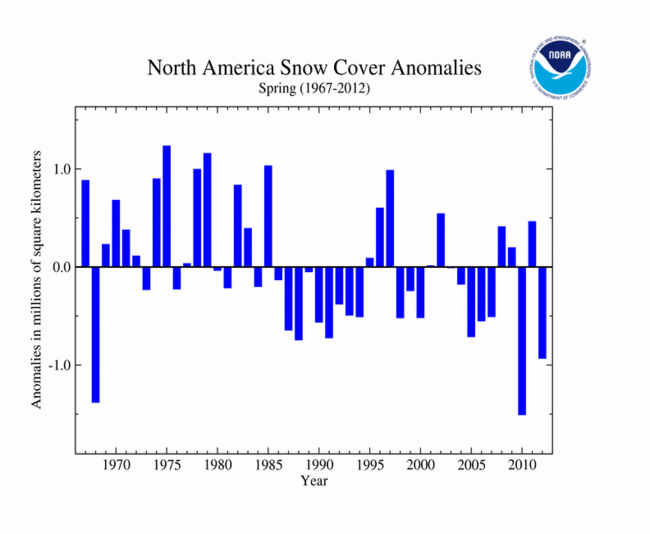
In addition, there is this, snow-cover extent in the Northern Hemisphere this past spring has been well-below average, and in the case of Eurasia, the lowest ever measured.http://www.ncdc.noaa.gov/sotc/global-snow/2012/5


NH Snow Cover Extent

Data were provided by the Global Snow Laboratory, Rutgers University. Period of record is 1967-2012 (46 years).


The Northern Hemisphere snow cover extent (SCE) during May 2012 was much below average and ranked as the second smallest May SCE in the 46-year satellite period of record. The monthly SCE was 3.47 million square km below the long-term average of 19.4 million square km (7.5 million square miles). This marks the eighth consecutive May with below-average May snow cover for the Northern Hemisphere. Both the Eurasian and North American land areas had below-average snow coverage for the month. For the spring period (March-May), the Northern Hemisphere SCE was 1.9 million square km (735,000 square miles) below average, ranking as the sixth smallest spring snow extent on record. This is the ninth consecutive spring with below-average spring snow cover for the hemisphere.
During May 2012, the North American SCE was nearly 0.8 million square km (310,000 square miles) below average, ranking as the eighth smallest May SCE on record. According to analysis by Rutgers Global Snow Lab, the mountainous West of the U.S. had below-average snow cover during May, as well as most of eastern and central Canada. Above-average snow cover was observed across the Canadian Rockies and southern Alaska. For spring (March-May), the North American SCE was the third smallest on record, 0.9 million square km (0.35 million square miles) below average.
Eurasian SCE during May 2012 was 2.67 million square km (1.0 million square miles) below average, the smallest May snow extent on record for the continent. This is in sharp contrast to February 2012, when the Eurasian SCE was the third largest for the month. A warm spring led to rapid snow melt across much of the continent. According to analysis by Rutgers Global Snow Lab, below-average snow cover was observed across the Alps, most of Russia, the Himalayas, and northwestern China. Above-average snow cover was present for Scandinavia and parts of the Tibetan Plateau. For the spring season (March-May), the Eurasian SCE was nearly 1.0 million square km (386,000 square miles) below average, the 12th smallest spring SCE on record for the continent.

As we've mentioned in previous articles, the loss of Arctic sea ice cover is a climatic "tipping point" that is leading to irreversible positive feedbacks, accelerating warming, and leading to increasing climatic chaos.

Which, if no action is taken to quickly reign in CO2 and Methane emissions from fossil-fuel combustion and oil/gas industrial activity, will leave us with a future like this:


I'm sure the people living in Colorado and the western Great Plains are wondering now what is happening, in spite of the deliberate suppression of any real information like this by the corporate media. Now that Denver has had six days of temperatures of 100F+ (including reaching it's all-time high of 105F two days ago) and wildfires are knocking on the door of several cities there. Fire activity in Siberia has also been the worst ever recorded so far this year, and it started early, in mid-April, in it's southern sections.

Temperatures in some towns in western Kansas, Nebraska, Oklahoma, and Colorado, as well as eastern Montana and Wyoming have been between 105-115F (41-45C) over the past week! This after their warmest March and early April ever. Can you imagine what it will be like there in 20-30 years!?

                                                  KLUANE UPDATE

We just thought we'd bring you up to date on the activities and progress of the junior member of our staff, Kluane. Our two-year old husky/bernese mountain dog mix who never ceases to amaze us with his rapid learning, enthusiasm, and energy, as he aides in our research, and accompanies us on all our back-country outings.

Kluane bonded with us quickly and well over this past winter, and most of the time stayed close to Mattie and I on our various trips, on skis or foot, as on this hike behind the C.F.R.C. last May, to the top of 1433 metre Konoya pt. He does have a disturbing tendency to chase after and try and herd moose, even cows with calves, but by last January, was at least listening to us, and returning back, when he wanted to do that.

His hardest lesson though was about five weeks ago, in our beloved Eagle River canyon. The river here flows fast and cold from glacial and regular snowmelt. On a day when we planned to do about a 35 KM run on the Iditarod trail from the Eagle R. nature centre, about 10 KM in, he plunged into the cold fast river at Rapids Camp, and was swept to the other side.
He ended up on the opposite shore, unable to swim back to us. The water here is flowing faster than we can run, and is about 2-3C in temperature. After some coaxing from Mattie and I, he walked upstream to a slightly wider, slower section and attempted to swim back to us. The flow was too strong though, and he got caught on a rock near us, but about a metre down from the rocks we were standing on. Fortunately a compassionate bystander saw his plight, and came to our aid. He stepped slightly over the edge whilst I anchored myself down on the rock and grabbed his outstretched arm and pack. He was then able to grab Kluane while I then pulled with all I had to get them up. Which worked, thank goodness. Because if we couldn't have pulled him out, Kluane would have been swept downstream, to meet an uncertain fate.

He learned well though, and in all our river/stream crossings since in different areas, he has been much more careful.

On a beautiful late afternoon/evening hike several weeks ago, up the very steep Bird Ridge trail, which rises precipitously 1100 metres in 7 km from Turnagain Arm, he was allowed to be completely free. He usually is great on hikes with us, never straying more than a few minutes away, and returning when we call.
Here he is on top of Bird Ridge, making the most of this beautiful and amazing scenery, with it's precipitous slopes. He twice ran down a few hundred metres on these very steep snow-covered slopes chasing ptarmigan, but never lost his footing.

We finally decided he was ready for and worthy of his promotion from intern, to Homer's old position, research assistant, just a few weeks ago, on our foggy Bold Ridge trail hike, which takes you above beautiful clear, blue, Eklutna Lake, source of much Anchorage's power, and water supply.
This hike requires biking in though 9 KM from the Eklutna Lake parking area to the Bold Ridge Trail. He stayed with Mattie and I during this, the hike up Bold Ridge, and for the return, never staying out of our site more than a minute or two. And of course, having to cool off in the snow near the top of our hike at 1400 metres elevation.
Just a week before this, we were greatly impressed with his behaviour on our short overnight 44KM round-trip trek from the CFRC to the sub-Arctic beauty of the Williwaw Lakes area, to the southeast and 1000 metres higher in elevation.
He again stayed near us at all times, never straying for a moment or two, on the trip up, and back down. While we were camped that night, in that beautiful canyon, with Dall Sheep high up on the south-facing slope, he kept outer-perimeter guard. He also visited and greeted a couple camped about 500 metres away, but not begging or stealing, they really enjoyed meeting him.

Congratulations on your promotion Kluane, and thank you for help, protection, and companionship! Cheers.

Tuesday, June 5, 2012

ARCTIC AMPLIFICATION

Arctic Amplification refers to the fact the Arctic as a whole, over the last 40 years has warmed twice as much as the rest of the World, due to changes in sea ice extent and duration, as well as land-based snow cover because of warming caused by CO2 emissions from fossil fuels combustion.  

If that weren't bad enough, it now turns out that there are two "positive" feedback mechanisms kicking into gear, as the Arctic continues to warm due to Anthropogenic Global Warming. Melting/thawing permafrost, which releases methane, CH4, a greenhouse gas at least 22x more potent than carbon dioxide, CO2, and now, a new one, the increasingly smaller and thinner Arctic sea ice cover:
http://www.treehugger.com/climate-change/nasa-discovers-brand-new-global-warming-feedback-loop.html

http://www.bbc.co.uk/news/science-environment-18120093


"As if the melting methane-packed permafrost and shrinking Arctic ice sheets weren't enough, NASA scientists have gone and uncovered a brand new feedback loop that could hasten climate catastrophe. Climate feedback loops, to the uninitiated, are phenomena that worsen the warming effect when triggered—which further worsens said phenomena, and around we go.

The permafrost is probably the gnarliest: there's a truly stupendous amount of greenhouse gases trapped in the frozen tundras across Siberia, Alaska, Canada, etc. As the permafrost melts, it releases those gases into the atmosphere, which warms it up, and melts more permafrost. If warming keeps apace, permafrost could soon contribute 35% of worldwide greenhouse gas emissions. That's terrifying.

So is this: "Researchers have known for years that large amounts of methane are frozen in Arctic tundra soils and in marine sediments ... But now a multi-institutional study led by Eric Kort of NASA’s Jet Propulsion Laboratory [ science! eds... ] has uncovered a surprising and potentially important new source of methane: the Arctic Ocean itself."

That emphasis is mine, and a correct reading of the quote will include a dramatic and cartoony 'duhn-duhn-duhn' sound effect registered immediately after. And believe you me, it's justified. NASA scientists say that when they flew research flights over areas in the Arctic Sea where the ice was breaking up, they encountered higher than usual levels of methane. They then set out trying to determine where it came from:
By comparing the locations of the enhanced methane levels with airborne measurements of carbon monoxide, water vapor, and ozone, the researchers from six institutions pinpointed a source: the ocean surface, in places where there were cracks and openings in the sea ice cover. The cracks were allowing methane in the top layers of the sea to escape into the atmosphere. The team did not detect enhanced methane levels over areas of solid ice.
Kort noted that previous studies had detected high concentrations of methane in Arctic surface waters, but no one had predicted that this dissolved methane would find its way into the overlying atmosphere ... “It’s possible that as large areas of sea ice melt and expose more ocean water, methane production may increase, leading to larger methane emissions,” he said. “While the methane levels we detected weren’t particularly large, the potential source region, the Arctic Ocean, is vast."
In other words, cracks in sea ice are allowing methane trapped in surface ocean to escape into the atmosphere. More warming means more cracks, which means more methane (and remember methane is a much more potent heat-trapping gas than carbon), which means more cracks.

Further investigation certainly must be done to uncover the true scope of this threat, but it certainly doesn't sound good..."

Researchers over the past several years have established that the last time global the atmospheric concentration of CO2 was 390 ppm (250,000 years ago),  sea levels were 5-7 metres (18-25 ft.) higher than they are currently. Just 50 years ago the CO2 concentration was 300 ppm.

And now, at several places across the Earth, measurements of 400 ppm are being recorded:

It is unknown, at this time, how long it will take the planetary global atmospheric/oceanic/climate system to respond, and sea levels to rise the inevitable 8 or more metres, from what they are now. It could take a few decades, or a few centuries. That will make a big difference, in how developed "civilisation" as we know it, will be able to respond, and continue, without massive disruptions.
Given all that, and the fact that globally, droughts, flooding, severe weather, and increasing climate chaos will continue to escalate as we continue to increase atmospheric CO2 concentrations of 4-5 ppm yearly with no concerted global effort to decrease them, what are we seeing in this country, any signs of concern or effort to address this increasingly dire situation?

Well, no, what we get is this:
http://www.commondreams.org/view/2012/05/24-4
How Obama Helped Authorize Shell's Drilling the Arctic

by Pratap Chatterjee

President Barack Obama personally helped Shell obtain authorization to drill for oil in Alaska, according to a 4,678 word front page article in the New York Times. This is a startling break from decades long U.S. policy which regarded the environment in the Arctic region too fragile to tamper with.

“(T)he president concluded that the reward was worth the risk, and created an unusual interagency group, overseen by a midlevel White House aide, to clear Shell’s path through the often fractious federal regulatory bureaucracy,” write John Broder and Clifford Krauss.

In November 2010, almost two years after he was elected, Obama told William K. Reilly and Carol M. Browner, two former heads of the Environmental Protection Agency, what he wanted them to do. “Where are you coming out on the offshore Arctic?” he asked. “What that told me,” Reilly told the New York Times, “was that the president had already gotten deeply into this issue and was prepared to go forward.”

The article describes the clash between two powerful men, Edward Itta, the former mayor of Inupiat North Slope Borough, and Pete Slaiby, Shell Alaska vice president. The story is already the basis of a new book, “The Eskimo and the Oil Man: The Battle at the Top of the World for America’s Future,” by Bob Reiss.

Shell spent over $35 million lobbying for the permission during the Obama adminstration. Marvin Odum, president of Shell North America, and Sara B. Glenn, a lobbyist, visited the White House 19 times to meet with Obama’s staff.“We never would have expected a Democratic president — let alone one seeking to be ‘transformative’ — to open up the Arctic Ocean for drilling.” --Michael Brune, executive director of the Sierra Club

Some environmental groups are astonished at Obama’s role. “We never would have expected a Democratic president — let alone one seeking to be ‘transformative’ — to open up the Arctic Ocean for drilling,” Michael Brune, executive director of the Sierra Club told the New York Times.

Protests against Shell’s plan have been ongoing for years. On Wednesday, activists launched two reports at the company’s annual meeting in the Hague. “Risking Ruin : Shell’s dangerous developments in the Tar Sands, Arctic, and Nigeria report” by the Indigenous Environmental Network (IEN) and “Out in the Cold – Investor Risk in Shell’s Arctic Exploration” from Platform, Greenpeace and FairPensions.

“Our village has been there 4000 years. Our biggest concern is spilled oil getting into the ocean and affecting the marine mammals that we depend upon. Your clean-up ability is not adequate,” Robert Thompson, a village of Kaktovik on the edge of the Arctic Ocean in Alaska, told shareholders.

Others indigenous activists spoke out also about Shell’s impact in other countries. “Shell has failed to address our concerns in Canada’s tar sands, by not meeting environmental standards and past agreements, and refusing to address their impacts on our constitutionally-protected treaty rights, leaving us with no option but to sue them,” said Eriel Deranger from Athabasca Chipewyan First Nation (ACFN). “Our Chief has said ‘Enough is enough!’ We fully intend to challenge all Shell’s future projects until they can demonstrate a true willingness to implement our rights.”

According to a report from the UK Tar Sand Network, five protestors wearing masks that combined Shell’s logo with a skull stood silently throughout the meeting reminding the shareholders of the grave human rights and environmental injustices Shell has brought to communities in Nigeria, Rossport (Ireland), the Arctic and Canada.

Friday, April 13, 2012

DRIVEN OUT [and] BREAK-UP FLIGHT

http://www.myspace.com/video/vid/36228074
Driven out by thieves
I watch them pillage the planet
Fueled by a fattening breeze
Trees fall to the hatchet

We're chopping against the grain
Our spirits in a vacuum
Sadly ignore the pain
The end arrives, we all lose
We all lose
I hope it comes, it comes, it comes around

Driven out
Holding out
Day by day survival
Castaways have silent lives
With a strength to rival you

So now I'm driving in my car
I used to be able to walk this far
Now I turn on the light
I used to be able to sleep at night

I'm cooking with microwaves
To warm up food that's not seen the soil
Plugged into my TV
Yeah, I'm used to the lies they're telling me
They're telling me
I hope it comes, it comes, it comes around

Driven out
Holding out
Day by day survival
All castaways have silent lives
With a strength to rival
Driven out
Holding out
Driven out
Holding out
With a strength to rival you

So now I'm hoping that we'll find
More to life than meets the eye
Can we escape the grind?
Live a life that's more worthwhile?
Get rid of this empty pride
Let's pull our foolishness inside
Debate in a turning tide
Until then, we all hide
We all hide
I hope it comes, it comes, it comes around

Driven out
Holding out
Day by day survival oh
Castaways have silent lives
With a strength to rival
Driven out
Holding out
Yeah, it could take up your best time
Driven out
Holding out
With a strength to rival you
Rival you, oohoo

This was one of your lead editor's favourite songs back in the day, "Driven Out", by THE FIXX, from their "Calm Animals", 1989 CD release. Even then this band was onto our greed-based society and it's pathologies, that is destroying the Natural World, and which will end up destroying civilisation as we know it, if it is not changed in the next few decades.

It's not just the U.S. that has always been this way, and is becoming even increasingly more so, but the global corporatocracy/financial sector/military-industrial complex, is now bent on forcing many of the countries in Europe to forego most, or all, of their social benefits, in "Austerity" drives, in order that obscene profits can continue, at the expense of working people. No one knows this better, and can deliver a penetrating analysis of this situation, than Paul Craig Roberts, former Assistant Secretary of the Treasury during the Reagan administration. He has since changed his viewpoints on national and global political issues, and is now quite outspoken. This article lays out his latest assessment on the dismal state of the national and global economic/financial system.
http://www.counterpunch.org/2012/05/21/bet-on-collapse/

Recovery or Collapse?

Bet on Collapse

by PAUL CRAIG ROBERTS
The US financial system and, probably, the financial system of Europe, like the police, no longer serves a useful social purpose.

In the US the police have proven themselves to be a greater threat to public safety than private sector criminals. I just googled “police brutality” and up came 183,000,000 results.

The cost to society of the private financial system is even higher. Writing in CounterPunch (May 18), Rob Urie reports that two years ago Andrew Haldane, executive Director for Financial Stability at the Bank of England (the UK’s version of the Federal Reserve) said that the financial crisis, now four years old, will in the end cost the world economy between $60 trillion and $200 trillion in lost GDP. If Urie’s report is correct, this is an astonishing admission from a member of the ruling elite. Try to get your mind around these figures. The US GDP, the largest in the world, is about 15 trillion. What Haldane is telling us is that the financial crisis will end up costing the world lost real income between 4 and 13 times the size of the current Gross Domestic Product of the United States. This could turn out to be an optimistic forecast.

In the end, the financial crisis could destroy Western civilization.

Even if Urie’s report, or Haldane’s calculation, is incorrect, the obvious large economic loss from the financial crisis is still unprecedented. The enormous cost of the financial crisis has one single source–financial deregulation. Financial deregulation is likely to prove to be the mistake that destroys Western civilization. While we quake in our boots from fear of “Muslim terrorists,” it is financial deregulation that is destroying us, with help from jobs offshoring. Keep in mind that Haldane is a member of the ruling elite, not a critic of the system like myself, Michael Hudson, or Pam Martens, to menion some CounterPunch contributors.)

Financial deregulation has had dangerous and adverse consequences. Deregulation permitted financial concentration that produced “banks too big to fail,” thus requiring the general public to absorb the costs of the banks’ mistakes and reckless gambling.

Deregulation permitted banks to leverage a small amount of capital with enormous debt in order to maximize return on equity, thereby maximizing the instability of the financial system and the cost to society of the banks’ bad bets.

Deregulation allowed financial institutions to sweep aside the position limits on speculators and to dominate commodity markets, turning them into a gambling casino and driving up the prices of energy and food. [this is why gasoline in Anchorage, AK has now risen to $4.44 per gallon, in spite of the price of crude oil having fallen, eds..]

Deregulation permits financial institutions to sell naked shorts, which means to sell a company’s stock or gold and silver bullion that the seller does not possess into the market in order to drive down the price.

The informed reader can add more items to this list.

The dollar in its role as world reserve currency is the source of Washington’s power. It allows Washington to control the international payments system and to exclude from the financial system those countries that do not do Washington’s bidding. It allows Washington to print money with which to pay its bills and to purchase the cooperation of foreign governments or to fund opposition within those countries whose governments Washington is unable to purchase, such as Iran, Russia, and China. If the dollar was not the world reserve currency and actually reflected its true depreciated value from the mounting US debt and running of the printing press, Washington’s power would be dramatically curtailed.

The US dollar has come close to its demise several times recently. In 2011 the dollar’s value fall as low as 72 Swiss cents. Investors seeking safety for the value of their money flooded into Swiss francs, pushing the value of the franc so high that Switzerland’s exports began to suffer. The Swiss government responded to the inflow of dollars and euros seeking refuge in the franc by declaring that it would in the future print new francs to offset the inflows of foreign currency in order to prevent the rise in the value of the franc. In other words, currency flight from the US and Europe forced the Swiss to inflate in order to prevent the continuous rise in the exchange value of the Swiss currency.
Prior to the sovereign debt crisis in Europe, the dollar was also faced with a run-up in the value of the euro as foreign central banks and OPEC members shifted their reserves into euros from dollars. The euro was on its way to becoming an alternative reserve currency. However, Goldman Sachs, whose former employees dominate the US Treasury and financial regulatory agencies and also the European Central Bank and governments of Italy and, indirectly, Greece, helped the Greek government to disguise its true deficit, thus deceiving the private European banks who were purchasing the bonds of the Greek government. Once the European sovereign debt crisis was launched, Washington had an interest in keeping it going, as it sends holders of euros fleeing into “safe” dollars, thus boosting the exchange value of the dollar, despite the enormous rise in Washington’s own debt and the doubling of the US money supply.

Last year gold and silver were rapidly rising in price (measured in US dollars), with gold hitting $1,900 an ounce and on its way to $2,000 when suddenly short sales began dominating the bullion markets. The naked shorts of gold and silver bullion succeeded in driving the price of gold down $350 per ounce from its peak. Many informed observers believe that the reason Washington has not prosecuted the banksters for their known financial crimes is that the banksters serve as an auxiliary to Washington by protecting the value of the dollar by shorting bullion and rival currencies.

What happens if Greece exits the EU on its own or by the German boot? What happens if the other EU members reject German Chancellor Merkel’s austerity, as the new president of France promised to do? If Europe breaks apart, do more investors flee to the doomed US dollar?

Will a dollar bubble become the largest bubble in economic history?

When the dollar goes, interest rates will escalate, and bond prices will collapse. Everyone who sought safety in US Treasuries will be wiped out.

We should all be aware that such outcomes are not part of the public debate.

Recently Bill Moyers interviewed Simon Johnson, formerly chief economist of the International Monetary Fund and currently professor at MIT. It turns out that deregulation, which abolished the separation of investment banks from commercial banks, permitted Jamie Dimon’s JPMorganChase to gamble with federally insured deposits. Despite this, Moyers reports that Republicans remain determined to kill the weak Dodd-Frank law and restore full deregulation.

Simon Johnson says: “I think it [deregulation] is a recipe for disaster.” The problem is, Johnson says, that correct economic policy is blocked by the enormous donations banks make to political campaigns. This means Wall Street’s attitudes and faulty risk models will result in an even bigger financial crisis than the one from which we are still suffering. And it will happen prior to recovery from the current crisis.

Johnson warns that the Republicans will distract everyone from the real crisis by concocting another “crisis” over the debt ceiling.

Johnson says that “a few people, particularly in and around the financial system, have become too powerful. They were allowed to take a lot of risk, and they did massive damage to the economy — more than eight million jobs lost. We’re still struggling to get back anywhere close to employment levels where we were before 2008. And they’ve done massive damage to the budget. This damage to the budget is long lasting; it undermines the budget when we need it to be stronger because the society is aging. We need to support Social Security and support Medicare on a fair basis. We need to restore and rebuild revenue, revenue that was absolutely devastated by the financial crisis. People need to understand the link between what the banks did and the budget. And too many people fail to do that.”

Consequently, Johnson says, the banksters continue to receive mega-benefits while imposing enormous social costs on society.

Few Americans and no Washington policymakers understand the dire situation. They are too busy hyping a non-existent recovery and the next war. Statistician John Williams reports that when correctly measured as a cost of living indicator, which the CPI  [consumer price index, eds..] no longer is, the current inflation rate in the US is 5 to 7 percentage points higher than the officially reported rate, as every consumer knows. The unemployment rate falls because, and only because, people unable to find jobs drop out of the labor force and are no longer counted as unemployed. Every informed person knows that the official inflation and unemployment rates are fictions; yet, the presstitute media continue to report the rates with a straight face as fact.

The way the government has rigged the measure of unemployment, it is possible for the US to have a zero rate of unemployment and not a single person employed or in the work force.

The way the government has the measure of inflation rigged, it is possible for your living standing to fall while the government reports that you are better off.

Financial deregulation raises the returns from speculative schemes above the returns from productive activity. The highly leveraged debt and derivatives that gave us the financial crisis have nothing to do with financing businesses. The banks are not only risking their customers’ deposits on gambling bets but also jeopardizing the country’s financial stability and economic future.

With an eye on the approaching dollar crisis, which will wreck the international financial system, the presidents of China, Russia, Brazil, South Africa, and the prime minister of India met last month to discuss forming a new bank that would shield their economies and commerce from mistakes made by Washington and the European Union. The five countries, known as the BRICS, intend to settle their trade with one another in their own currencies and cease relying on the dollar. The fact that Russia, the two Asian giants, and the largest economies in Africa and South America are leaving the dollar’s orbit sends a powerful message of lack of confidence in Washington’s handling of financial matters.

It is ironic that the outcome of financial deregulation in the US is the opposite of what its free market advocates promised. In place of highly competitive financial firms that live or die by their wits alone without government intervention, we have unprecedented financial concentration. Massive banks, “too big to fail,” now send their multi-trillion dollar losses to Washington to be paid by heavily indebted US taxpayers whose real incomes have not risen in 20 years. The banksters take home fortunes in annual bonuses for their success in socializing the “free market” banks’ losses and privatizing profits to the point of not even paying income taxes.

In the US free market economists unleashed avarice and permitted it to run amuck. Will the disastrous consequences discredit capitalism to the extent that the Soviet collapse discredited socialism?  [we think it already has, eds...]

Will Western civilization itself survive the financial tsunami that deregulated Wall Street has produced?

Ironic, isn’t it, that the United States, the home of the “indispensable people,” stands before us as the likely candidate whose government will be responsible for the collapse of the West.

PAUL CRAIG ROBERTS was an editor of the Wall Street Journal and an Assistant Secretary of the U.S. Treasury. His latest book, HOW THE ECONOMY WAS LOST, has just been published by CounterPunch/AK Press. He can be reached through his website

We see nothing to disagree with in Mr. Robert's assessment. This is the kind of society we now have, one in which corporate profits are the driving force behind all policy decisions, no matter the cost to the environment, and people's health and livelihoods. All wars waged by the U.S., with help from other "allied" nations, have been, since World War 2, fundamentally driven by this, and will continue to be so.
That is why it is so important to support movements like Occupy, and others that work for sane, just, and sustainable policies, so we can reform societies into ones in which the health and protection of people, and the environment is the driving force and main priority. For us at the Alaska Progressive Review, we will no longer ever vote for any Democratic (and it goes without saying, Republican) politicians. The Democrats, as witnessed by the Obama Administration, are completely dominated and driven by Wall Street and the global financial elite. Have you ever heard from this administration, any pledges to eradicate poverty, enact massive jobs programmes, and provide support to private enterprise to increase employment? Of course not, and you won't. It will only take massive direct action through demonstrations and strikes, along with gradual replacement of politicians from other parties, to accomplish positive changes.

One thing though at we can't strongly emphasize enough is to move all your financial interests away from the big banks if you can, and into credit unions. PLEASE, PLEASE do this as much as you can, you will be doing yourself, your community, your state, nation, and the World, a world of good by doing so. We certainly understand, for example, with mortgages, it takes thousands of dollars to shift out of one, to another, but if everyone would shift their banking and credit cards and smaller loans out of the greedy, sociopathic large financial institutions, much will be gained.

Almost everyone in Alaska uses an Alaska Airlines credit card for purchases, to gain airline miles, and eventually, first-class upgrades, or free/reduced tickets. But we here at the A.P.R. just couldn't stomach that these are run by one of the worst, greediest, financial institutions in the U.S., Bank of America. We cut ours up in 2009, and shifted over to a credit union credit card (Alaska USA Federal Credit Union, www.alaskausa.org,) which still does offer travel benefits, and sleep much better at night now, knowing we are not supporting that destructive enterprise/system (and the interest rate is much lower).
                              BREAK UP FLIGHT

The Alaska Progressive Review has been on hiatus for the last several weeks, for a few different reasons. Mainly though, your lead editor needed to do an extended family and friends tour in the lower 48. With the added benefit of missing out on the worst of this year's especially messy, slushy, muddy spring break-up/melt out, due to our record-breaking snowpack.

Mattie and Kluane continued their presence here at the Chugach Front Research Centre, whilst I flew to Portland, OR, rented a car, then drove south to San Diego, CA, then north back to Portland, OR, via Missoula, MT, a place I lived in from 1990-98, and really grew to love. Missoula to me epitomises the best in "latte towns", progressively-oriented small cities with public universities. A place where wilderness is always close at hand, yet progressive views and people are in the majority. A place we feel the need to be in occasionally, to get refreshed in a community of like-minded people. Since Alaska, is, as you know, much more conservative overall than say, western Oregon and Washington. Because it has had such a great influence from the military and oil industry from the late 1960s onward. But we're not giving up on Alaska, the beauty and ease of access to true wilderness, makes up for diminished level of progressive culture here. And it is changing, more and more people who appreciate, respect, and feel the necessity of protecting the environment move here every year. Please keep coming, Alaska needs you!

Even though the goal of this trip was to visit family and friends, I always seek and am usually able to to find some little relatively wild place, wherever I am, to run, hike, or bike in. After flying to Portland, OR last month, and spending a week with my mother, we drove down to San Diego via my favourite route, US-395, down the east side of the Sierra Nevada mountains. First we stopped though in Ashland, OR to see our good friend Rebecca Chandler, Homer's mother! She is doing very well there, and Ashland is another refreshing "latte town", home to Southern Oregon State Univ., and the World-famous Shakespeare Festival, which goes on half the year. It is like Missoula, but half-sized. After leaving Ashland, our first evening on the road found us in the little town of Bridgeport, CA, at an elevation of 1951 metres (6400 ft.), on the east slopes of the Sierra. It is a beautiful area, and I had to get out for a good run here.
In the evening, I just ran up US-395 for about 6 KM, then found some dirt tracks up the hills on the east side of the highway. Ascending a few hundred metres through the fragrant pinyon-pine and juniper woodlands here gave me views like this, of the majestic higher Sierra peaks, peeking through the clouds of a late-season winter storm.

The next morning I went for another run, but this time up a dirt road right behind town, as I'd been told by our motel manager that there was a hot spring in the area. Running up just about 6 km from town, I found these gems. Travertine Hot Springs.
There were a few people camping off the road, but when I ran in to the springs in the morning, no one was in them. And they were perfect, probably right around 36-40C, just right for soaking. But I didn't have time for that, so just had to admire them for a few minutes. I'd like to get back here though, hot springs like this, with so few people, are a treasure. And there are vast networks of trails into the eastern Sierra here that we could run, hike, or ski in, for days and days. This area of the Sierra Nevada, being further north from LA, and 2+ hours south of Reno, NV, is much more lightly traveled in, than further north, or south. Which is also why Bridgeport is so small, about 500 souls, and not really growing. It's also a very interesting area physically, the ecosystems rapidly shift from moist high-Sierra coniferous forests at their bases, to the drier Pinyon Pine/Juniper/Sagebrush, heading east and down in elevation, and then to the complete high-desert sagebrush. All in very rocky, steep settings.
Heading further south the next day, we passed through one of my favourite areas anywhere, the eastern slopes of the Sierra from Bridgeport, south through the Owens Valley. In which, the highest Sierra peaks form an amazing sheer 3200 metre (10,500') vertical wall on it's western side. Which never ceases to amaze me and leaves me wanting to also spend more time in, never having had the chance when I was younger, growing up in San Diego. Here from Lone Pine, Mt. Whitney at 4217 metres (14,495'), the highest point in the lower 48, would occasionally peak through the storm clouds, but I couldn't quite catch it. The geology of this area is equally as interesting, full of volcanic fields, some fairly recent and potentially active, east of that sheer eastern spine of the highest Sierra peaks.

Once in San Diego, our great friend Erik Skye came down to join us there, and then drive up to Missoula, MT. In San Diego, Erik and I made sure to run in our favourite wild places there, Mission Trails Regional Park.
Which has many KM of rocky, steep trails in actual wild, undeveloped land about 10-15 miles inland from the coast.
Although this picture had some haze, due to the camera being in my short's pocket for our 2 hr. run, you can see that this century plant was in bloom, here at the end of April, and although the winter's precipitation in San Diego was about 6 cm below average, a good wetting rain had occurred just about 5 days before we arrived. So all the vegetation, even the grasses, were still green and vibrant. And some wildflowers were also still in bloom, very pretty.

Our other favourite area to be in, and especially run in, is the area between Del Mar and La Jolla Shores beach. This encompasses the incredibly beautiful, but small, Torrey Pines State Park. A little gem of preserved southern California wilderness. In which, remnants of a larger ice-age pine forest, remain, able to survive just along these remnants of cool, foggy coast in southern California. Incredibly beautiful views and trails in it. One of our favourite runs is from Torrey Pines S.P., south on the beach, around the cliff corner, then down world-famous clothing-optional and exceptional surfing spot, Blacks Beach. From there, up a steep cliff road to the Univ. of Calif. San Diego (UCSD), down La Jolla Shores Road to the beach, then back. About 23 KM (14 mi.), usually cool with nice breezes, and amazing views.
After which, the cool 15C (60F) waters at Torrey Pines beach beckon, though we don't stay in very long. But it sure does make us feel good after a nice run like that.
One of our favourite times while we were in San Diego was our little excursion east over the coastal range, to the desert, in Anza Borrego State Park, a place which I hadn't visited since I was a teenager.

With my mother, and sister Mischelle, we made it down from the cool 1280 metre (4200') heights of Julian, to the lower desert floor of Borrego Springs, where temperatures were around 35C (95F). But most of the desert cacti were in bloom, so it was a great time to be there. All the more so when Erik and I went for a walk up the Palm Canyon trail, in the blazing early afternoon sun. After only walking up about 15-20 minutes, we came upon what in our view, was an amazing, and rare occurrence.
A herd of about 8 desert bighorn sheep were perched on the rocks just 50 metres in front of us. These sheep are very elusive, and rarely seen by most people. That we had this close of access to them was an incredible gift.
This mother and calf were our favourite of the flock, they really are beautiful, and so at home in these surroundings. Which considering how harsh, hot and dry it is for half the year here is quite a feat. It looks like the mother has some kind of tracking device on it. I'm sure this herd is studied and managed to some degree, to make sure they continue. Long may they.
Look at how well this young male blends in with his surroundings. So that from a distance, when he is still, is undistinguishable from the rocks. Great protection from the mountain lions and coyote here! Their habitat of course, over the last 150 years has been fragmented and developed, so only small areas of true wilderness like this remain. It still amazes us though how fortunate we were to see them, it was very inspiring, and something we'll never forget.

After our time in San Diego came to an end, we decided to head north toward Missoula, MT, but with a detour to Joshua Tree N.P., which Erik had never seen. And which is very interesting, and accessible.
The high desert here at 1000-1500 metres (3280-4900 ft) in Joshua Tree N.P. is very rocky, with huge boulders that offer world-class rock climbing, but that also supports the strange yucca-related Joshua Trees, as well as a Pinyon Pine-Juniper woodland accompanied by a diverse cactus flora in clear areas. Very interesting, and in full bloom during our visit. It was a warm 28-30C (82-86F) day when we arrived, but in the dry conditions there, was quite pleasant. The sun though was quite strong, so our extended hike was late in the afternoon and evening.
In the evening light, the rocks and yellow-flowered "bearded cacti" were quite beautiful. As were these purple-flowered cacti, which were quite plentiful. Even the juniper bushes were full of ripening berries. These are what are "capers" in mediterranean food, as well as the source of flavor for everyone's favourite gins.
The next day we hit the road north, toward Montana. We made it as far north as Filmore, UT on I-15, about halfway up the state, by 9pm. But before that, we had to stop for a run, heading southeast up a small road into the mountains from Parowan, just north of Cedar City. We went for a beatiful 80 min. run from 2000 metres (6460') to 2440 metres (8000') on a Dixie National Forest road, up through pinyon-juniper, eventually to wetter pine/spruce/fir stands which still had some patchy snow in them. Unfortunately, I forgot to bring my camera, but the landscapes here were every bit as beautiful as these around Bryce Canyon, UT, at similar elevations, which I visited in 9/2009. With the amazing orange/red martian-like rocks and contrasting greenery. We also saw two herds of deer on this run, and we both decided, this is a place we could easily live in! Having a colder climate for it's southerly latitude of 38N with winter snow, and even nordic skiing possible in the higher elevations, combined with abundant sun, and summer warmth.
The second day after Joshua Tree N.P. brought us up to Dillon, MT, where we spent the night, before the last push the next day, north and west, to Missoula.

Just before reaching Missoula, we had to pull in to one of my favourite places in that area to run, hike, and ski in. Kootenai Creek Trail, one of several east-west oriented canyons in the Bitterroot Mtns., the north-south oriented mountain range just to the south. All these canyons are 1000-1500 metres deep with steep, rocky slopes at the highest elevations, and large creeks in the canyon bottoms. And thickly forested in the most diverse and beautiful northern Rocky Mountain forest stands of Ponderosa and Lodgepole Pines, Englemann Spruce, Western Larch, Western Red-Cedar, and Grand and Subalpine Firs.
Kootenai Creek was in it's full spring snowmelt high-water flow. Deafening close-up, and with it's extreme drops, probably un-kayakable, except by only the most foolhardy. In my years in Missoula, 1990-98, I never heard of or saw anyone attempt that here.
Another run we had to do, while visiting Missoula, was up the Rattlesnake Creek trail, in the Rattlesnake Wilderness, north of town. An old railbed from mining days gradually rises over 15+ KM in the 1000+ metre deep canyon of Rattlesnake Creek.
Where up to 80 metre tall (262') Western Larch, just coming in to their spring green (the only deciduous conifers in the World) thrive. These trees, where they occur in the Alaska Interior, are known as Tamaracks, only reach about 10 metres height, and are spindly and twisted, growing in the coldest, swampiest areas.

We also decided Erik needed to see Glacier National Park USA, as he'd never been there (we did visit and hike in Glacier NP, BC, in 10/2010). So we did a quick 2-day drive north from Missoula. The Going to the Sun Highway was not opened yet for the season, plows were still breaking open 2100 metre Logan Pass, so we had to stop at the Avalanche Creek parking area, 20 KM west of the pass. But the map showed a beautiful 8 KM trail up to Avalanche Lake, at 1400 metres elevation. So we headed in on that, and were sure glad. This area of northwest Montana gets enhanced upslope precipitation along the spine of the Rockies, and so the forests are almost as moist as the Cascade ones in western Oregon/Washington, with large old-growth Western Red-Cedars, Hemlocks, and Englemann Spruce. From the heavy snowpacks received in these mountains, roaring pure streams cascade steeply down into the valleys below.
Avalanche creek tumbled down in a series of falls, the entire 8 KM along this trail, draining Avalanche Lake.
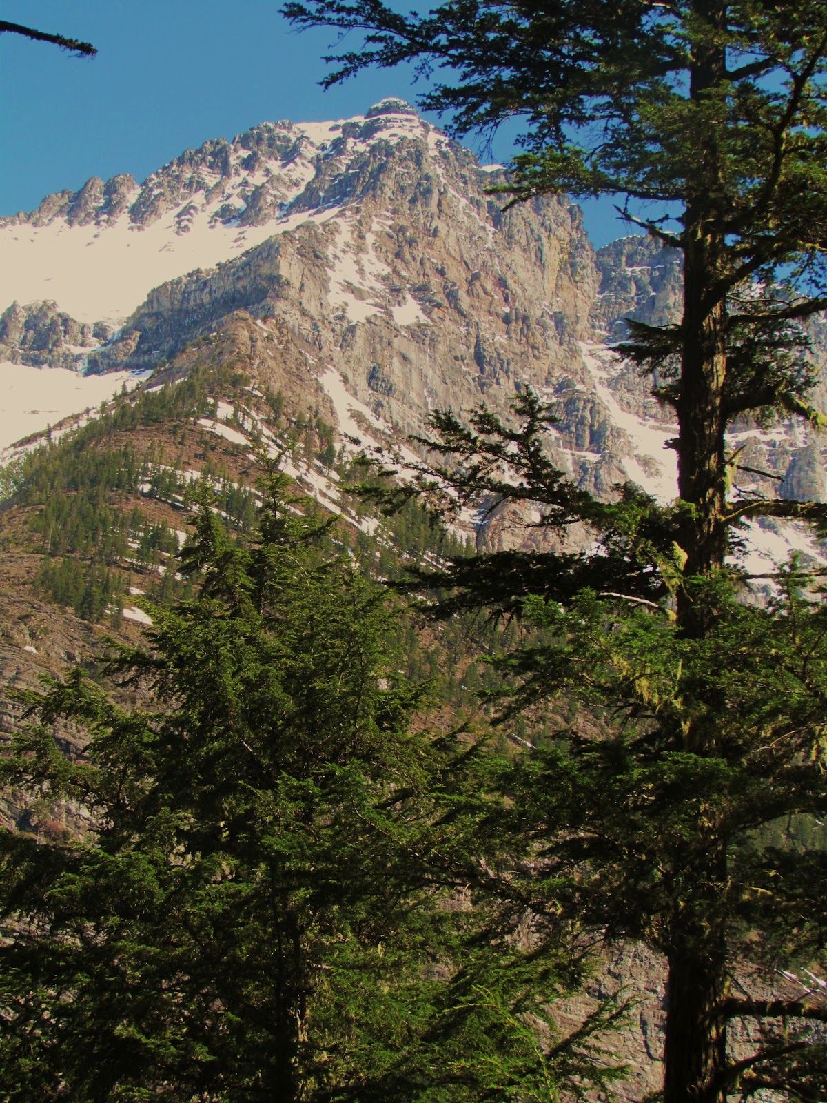
The higher 2500-3000 metre peaks were still covered in plentiful snow, in the bright, early May sun. When we reached Avalanche Lake, we walked up to the head of it, at which was a large avalanche, probably deposited a few weeks previously. From there, we could see the steep, craggy peaks, still with almost a full winter's accumulation of snow on their upper slopes, such as this one, 2810 metre Little Matterhorn Peak.
After spending five refreshing days in Missoula and western Montana, it was time to head west to Portland, so we could drop off our rental car, and fly back to Anchorage. But first, we had to stop in the Columbia Gorge, for one of my favourite running trails in the lower 48, Eagle Creek. I did a 43 KM (27 mi.) run here in 2007, but Erik and I only had time for about half that much. Eagle Creek is a fast, clear-flowing creek dropping from the Cascade Crest of northern Oregon, 1400 metres down to the Columbia River, much of it a very steep canyon, with dozens of waterfalls (Cascades!). Like this one, part of Punchbowl Falls, which is about 8 km up from the trailhead, in the Gorge. If you are ever in Portland, it is only 65 KM east on I-84, and it has it's own freeway exit. Well worth the time to run or hike in, this trail has rocky sections that have dropoffs of 100-200 metres down sheer cliffs to the roaring creek below. Definitely best when not wet or icy!
Our 2 hour run up this beautiful canyon on the warm May day (it was about 23C, 74F at the bottom) was greatly refreshing, after the long drive from Missoula. We made it back to the Portland area by 6pm, even with this nice run. So worth it. All in all, along with visiting family and friends, the natural areas we were able to be in, made this trip very enjoyable and relaxing. No matter where you go, there is always some peaceful natural setting within reach, which we are always quick to seek out. It always helps us to maintain our balance and bring solace from the pressures of the "civilised" world. Cheers.