

What is fast-packing? Simply put, it is just backpacking with lighter loads than typical for multi-day outings, allowing you to cover 25 to 35 miles or more in a day. Average speeds are typically just 2 to 3 mph, unless you plan on running parts of the route. Twenty pounds or less are the ideal for the fast-packer, as this smaller amount of weight affords you more mobility, less fatigue in the shoulders, and less stress on the knees and feet. A brisk 25 to 35 mile fast-pack on a steep, rocky route will give you a good workout, comparable to running a marathon, but without as much pounding on the joints, along with some inspiring and refreshing wilderness access. For those of us who enjoy endurance athletic activities, such as long-distance running, skiing, or biking, it is a great tool for maintaining our fitness as well as getting away from the daily routine. And given the vagaries and uncertainties of Alaskan environmental conditions, it can also provide you with unexpected and significant challenges.
I decided to do the Pinnell Mountain trail, as I had fast-packed the only other nearby similar trail, Chena Dome, back in May and had a great time. Pinnell is 27.3 miles, whereas Chena Dome was 31. Located on the Steese Highway, it has two trailheads, one at milepost 86 (12 Mile Summit) and milepost 10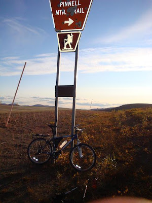 6 (Eagle Summit). This one I did alone in late August. I couldn’t bring intrepid little Mattie because I had to stash my bicycle at one end of the trail (12-Mile Summit), and bike the 20 miles back along the highway, to my car, where I started the hike, at Eagle Summit.
 6 (Eagle Summit). This one I did alone in late August. I couldn’t bring intrepid little Mattie because I had to stash my bicycle at one end of the trail (12-Mile Summit), and bike the 20 miles back along the highway, to my car, where I started the hike, at Eagle Summit.
The Pinnell Mountain and Chena Dome trails are classic interior Alaska tundra hikes, very rocky with occasional marshy or tussocky sections in saddles and low points, but expansive views in all directions on the summits. One thing to keep in mind with both of these is wind. It is almost always windy in these exposed areas, and if even what would seem to be a minor weather disturbance to us in the lowlands near Fairbanks moves in, fog and cold windy rain or snow will occur at these higher exposed elevations. Which is why extra layers, hat, gloves, maps, and a GPS are essential for your safety. I always check the weather forecasts before I undertake these fast-packs. The best place for accurate weather information and forecasts can be found on the National Weather Service’s web-site at http://pafg.arh.noaa.gov/, or by calling the Alaska Weather Information Line, 800-472-0391 (458-3745 in Fairbanks). You can also look at satellite and radar loops on the NWS web-site to help make your decisions.
 low points, but expansive views in all directions on the summits. One thing to keep in mind with both of these is wind. It is almost always windy in these exposed areas, and if even what would seem to be a minor weather disturbance to us in the lowlands near Fairbanks moves in, fog and cold windy rain or snow will occur at these higher exposed elevations. Which is why extra layers, hat, gloves, maps, and a GPS are essential for your safety. I always check the weather forecasts before I undertake these fast-packs. The best place for accurate weather information and forecasts can be found on the National Weather Service’s web-site at http://pafg.arh.noaa.gov/, or by calling the Alaska Weather Information Line, 800-472-0391 (458-3745 in Fairbanks). You can also look at satellite and radar loops on the NWS web-site to help make your decisions.
 The Pinnell Mountain trail, for me at least, was easier than the Chena Dome outing, because the elevation gains are less overall (the start at Eagle Summit is at 3600 feet, and the highest point, Mt. Pinnell is 4934 ft), and the ascents and descents on the steeper slopes are all switchbacked. Thus, I was able to complete the 27.3 miles of it in nine and a half hours, under beautiful sunny skies, in a stiff 15-25 mph cool (40-45 degrees) northeast wind. I kept to a brisk hiking pace the whole route, and just took four short breaks for food/water, and energy drinks, of 5 to 15 minutes each. I did slow down and take pictures at times too. One highlight of the trail was when I descended into the “Swamp Saddle” between miles 14 and 15. There in that marshy saddle were a herd of caribou. I stopped and s
The fall colors of the tundra were in full view, and this combined with the clear blue skies and craggy rocks, was stunning. Views north across the Yukon Flats and south through the seemingly endless uplands were a patchwork of brown tundra and fall color dropping down to the spruce and yellowing birch/aspen in the lower elevations.
The 20 mile return bike-ride from trails-end at 12-Mile Summit to my vehicle at Eagle Summit took just under two hours. It proved to be quite fun the first 10 miles downhill, slightly invigorating on the next five mile flat section, and highly challenging the last five uphill miles. A stiff headwind and falling temperatures in the 30s, combined with my overall fatigue from the long day of movement, made that quite memorable as I longed for Eagle Summit to come into view in the fading daylight while my feet began freezing (I had extra layers, but just didn’t want to stop). I had started the day at Eagle Summit at around 10 a.m., and it was near 10 p.m. when I returned to the sanctuary of my vehicle, heat, and warm, dry clothing. Like Chena Dome, Pinnell Mountain Trail is not very heavily used, especially well in from either trailhead. Hence, on the Friday before Labor Day, during my outing, I did not see a single person at any time. And, there are a few sections where the thin, rocky trail disappears and you just navigate to the next cairn or pylon in sight.
All in all, the day's outing went very well, no injuries, blisters, good weather, what more could I ask for? Now back to reality. While driving home at midnight, tired, but satisfied with my trip, I kept thinking about the craziness of this election season, and likely how little things will really change next year, even if the neo-fascist Republicans don't maintain their grip.
This is a good speech by Tom Hayden, given to activists at the Democratic Convention in Denver. While I feel his basic points are valid, he fails to go far enough. I can't vote for Obama, because neither he nor the Democratic party will acknowledge what has happened in the past 8 years as leading to the destruction of this country and its descent toward fascism, and indeed, have voted for and supported most of the worst events. The erosion of civil liberties (Patriot Act, Military Commissions Act), and the illegal, immoral, criminal invasion of Iraq. A country that was known by the administration to pose no threat to this or any other country, and which so far has cost the lives of upwards of a million innocent Iraqi civilians. All impeachable offenses, yet impeachment remains "off the table", thanks to Nancy Pelosi. http://www.downingstreetmemo.com/
So, I'm supporting Cindy Sheehan in her maverick run for Nancy Pelosi's congressional seat, and voting for Green party candidates this fall. Sure, we all know third parties in this country haven't a chance, given the corporate media's deliberate exclusion and ridicule of them, but we have to start somewhere. http://www.cindyforcongress.org/


